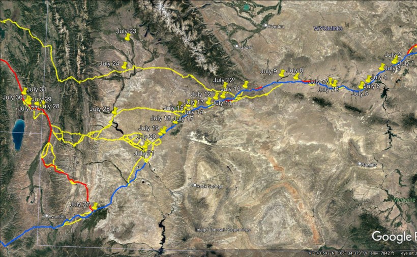
July 22 – A 5-month virtual road trip along the California Trail
Just north of where the Lander Road crossed Green River is the site of the Green River Rendezvous. You can visit the interpretive markers at Trappers Point Overlook near Pinedale, WY (GPS coordinates -109.982, 42.880). The Historical Marker Database provides information about those markers and the accompanying photograph at https://www.hmdb.org/m.asp?m=180108. It is where the fur trappers gathered during the 1830s and early 40s to compare adventures and exchange wares. They were key to the exploration of the west and you can read more about them at https://www.wyohistory.org/encyclopedia/fur-trade-wyoming. The town of Pinedale has a re-creation of the Rendezvous (http://www.pinedaleonline.com/RendezvousDays.HTM) every year.
Father Pierre-Jean de Smet (https://open.library.ubc.ca/collections/bcbooks/items/1.0342830 pp. 216-218) was a Jesuit priest who accompanied the Bidwell/Bartleson party in 1841 until they broke off the Oregon Trail to make the first overland emigrant journey to California. In 1840, De Smet attended the Green River Rendezvous and led a mass there. He writes, “On the 30th [of June, 1840] I came to the rendezvous, where a band of Flatheads, who had been notified of my coming, were already waiting for me. This happened, as I said further back, on Green river, a tributary of the Colorado; it is the place whither the beaver-hunters and the savages of different nations betake themselves every year to sell their peltries and procure such things as they need…. After riding a few times around the camp, uttering at intervals shouts of joy, they dismounted and all came to shake hands with the whites in sign of friendship. I was invited to a council by some thirty of the principal chiefs. Just as among the Cheyennes, we had first to go through all the ceremonies of the calumet. To begin, the chief made a little circle on the ground, placed within it a small piece of burning dried cow-dung, and lit his pipe from it. Then he offered the pipe to the Great Spirit, to the sun, to the earth and the four cardinal points. All the others observed a most profound silence and sat motionless as statues. The calumet passed from hand to hand, and I noticed that each one had a different way of taking it…. I made known to them the motives of my visit, the commandment which God had given the Black-robes to go and preach his holy law to all the nations of the earth, the obligation that all peoples were under to follow it as soon as it was known to them, the everlasting happiness which it brings to all who follow it faithfully unto death, and hell with all its torments, which would be the lot of whomsoever should close his ears to the word of Jesus Christ. I laid before them the advantages which they would receive from a mission, and I ended by preaching to them the principal points of Christianity. [They] paid the greatest attention, and appeared struck with wonder at the holy doctrine that I had been explaining to them. They then took counsel among themselves for the space of half an hour, when the spokesman, in the name of all the chiefs, addressed me in the following words : “Black-gown, your words have entered our hearts; they will never go out from them. We wish to know and practice the sublime law that you have just made known to us, in the name of the Great Spirit, whom we love…”

July 23 – A 5-month virtual road trip along the California Trail
Just before arriving at the Green River Crossing on the Lander Trail, emigrants had to cross the New Fork River. The New Fork River Crossing Historic Park (http://www.newforkpark.org/ GPS coordinates -109.855, 42.614) is a 100-acre park located on the west bank of the New Fork River in western Wyoming, where tens of thousands of emigrants using the Lander Trail crossed in wagons and often camped. Today, nearly all major emigrant crossings now lie on developed private land. This park provides a unique opportunity for access to a river crossing that remains undeveloped and much like it looked when emigrants passed through here in the 1860s. The photograph comes from the park’s website listed above. Some of the interpretive signs available in the park are described on the Historical Marker Database at https://www.hmdb.org/m.asp?m=96954. You may also be interested in the article at https://www.wyohistory.org/encyclopedia/crossing-new-fork-river.
Ira Butterfield (https://www.octa-journals.org/merrill-mattes-collection/michigan-to-california-ira-h-butterfield-jr-1861) wrote on July 27, 1861, “Left camp at 3 a.m. and drove eleven miles to Green River Fork, but really the east fork of Green River [New Fork River]. A swift stream some twenty rods wide and three feet deep. We crossed in the afternoon, swimming the sheep. We did not lose a sheep. The mosquitoes were very thick, simply in clouds, and worried the stock as well as the men.” The next day he wrote, “drove eleven miles to Green River crossing. (This is the west fork and the larger stream.) At five and one-half miles, we struck the river and followed it up stream for five and one-half miles farther to a ford. Very hilly and road dusty.”

July 24 – A 5-month virtual road trip along the California Trail
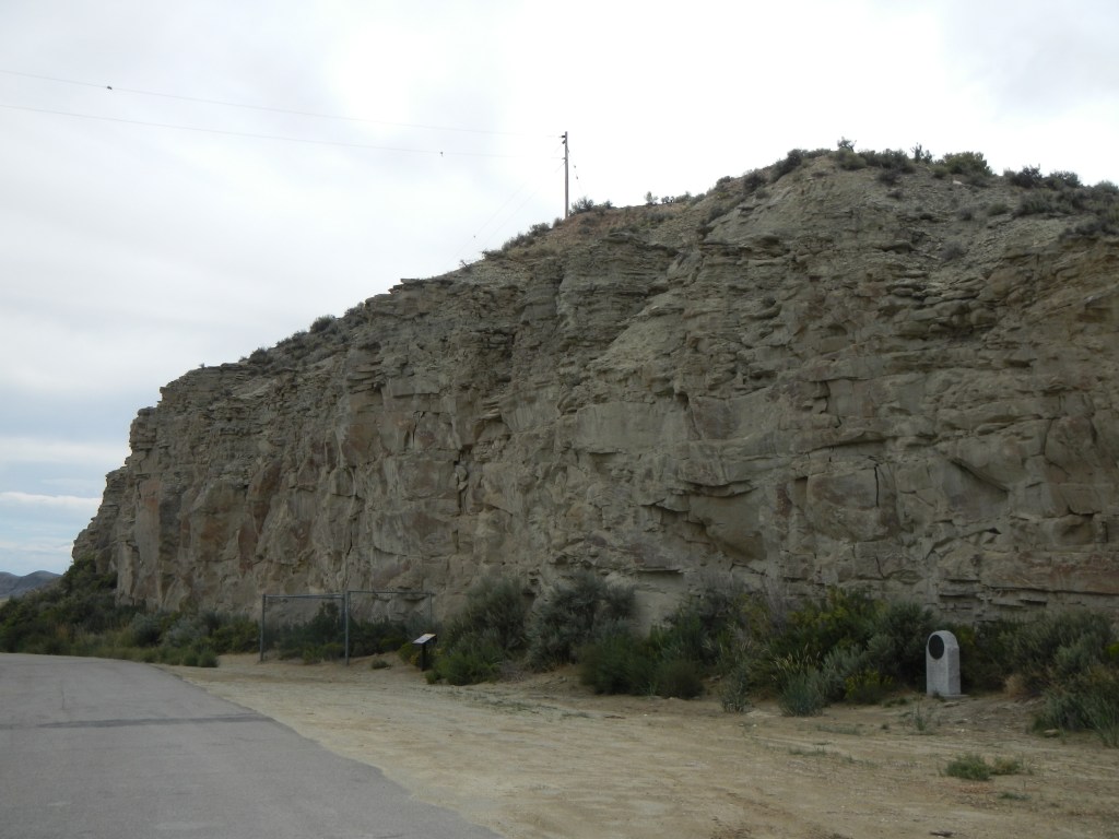
Returning now to the Sublette Cutoff crossing of Green River we find another place where emigrants enjoyed carving their names – Names Hill (GPS coordinates -110.188, 42.177). You can find descriptions of several markers on the Historical Marker Database at https://www.hmdb.org/m.asp?m=162509 and the accompanying picture comes from that site as well. The Wyoming State Historical Society article at https://www.wyohistory.org/encyclopedia/names-hill-oregon-trail-inscription-site also provides interesting background information.
J. Goldsborough Bruff described this cliff but did not mention emigrant names on it. However, he did describe a gravesite and a recent petroglyph, on August 7, 1849: “The mules must have good grass, which cannot be obtained here, so at 6 A.M. we moved on: and winding down the bottom, in about 2 ½ ms. Reached an ascent, rather steep, but not high, and just at the foot, on right of trail – 20 paces from it, vertical cliffs of a mouse-colored sand-stone, on the face of which was engraved with a fine-pointed instrument, an Indian diagram, representing 43 rifles, nearly vertical, and a chief and horse, apparently separated from 4 other indians and a horse laying down, by a stream with a small fork in it. This I accidentally discovered, by going close to the cliff, and at once drew it.” Bruff’s handwritten notes and sketch can be viewed at https://collections.library.yale.edu/catalog/9998550 on pages 106-107.
July 25 – A 5-month virtual road trip along the California Trail
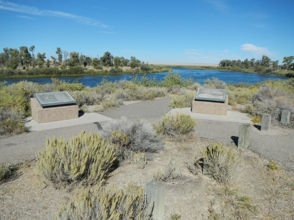
The Lombard Ferry (https://www.wyohistory.org/encyclopedia/lombard-ferry-green-river GPS coordinates -109.805, 41.880) across Green River on the Salt Lake City route and Fort Bridger route was first established by mountain men in 1843 and sold to Mormon operators in 1847. It later became known as the Lombard Ferry in 1889. The Historical Marker Database describes 7 interpretive markers at this location, including the ones in the photograph from https://www.hmdb.org/m.asp?m=88481.
Charlotte Allis’ diary from June 8, 1854 (http://digitalcollections.uwyo.edu/luna/servlet/media/book/showBook/uwydbuwy~139~139~3264030~288975) says, “We crossed the Green River today. This is a large and rapid stream. But there is a very good ferry, and we crossed in safety. Moreover it is not very safe crossing certain times in the day, for instance after the ferrymen all get the worse for liquer, as I understand they do get in this condition, which is endangering people’s lives. Yes, one poor man lost his life last season by the means of the miserable ferryman’s getting drunk. He left a wife and a family of children in Calafornia to mourn his loss. This man had a very large stock of cattle going to Calafornia and in crossing the ferry the men frightened the stock which caused the boat to sink, and the man drowned. Such is the effect of liquor, which is dreadful to think of. What must have been the agony of that wife and children…”
July 26 – A 5-month virtual road trip along the California Trail
A major junction point and wayside on the Oregon and California Trail was Fort Bridger (GPS coordinates -110.390, 41.318), established by famed explorer Jim Bridger. The site is now a Wyoming State Park (https://wyoparks.wyo.gov/index.php/places-to-go/fort-bridger) and includes 37 acres, 27 historic structures, 4 historic replica structures, and 6 modern structures. Bridger’s Trading Post and Fort appeared frequently in emigrant diaries.
On July 17, 1846 Edwin Bryant (https://archive.org/details/whatisawincalifoin00brya/page/142/mode/2up) described the site in this way: “‘Fort Bridger,’ as it is called, is a small trading-post, established and now occupied by Messrs. Bridger and Vasquez. The buildings are two or three miserable log cabins, rudely constructed, and bearing but a faint resemblance to habitable houses. Its position is in a handsome and fertile bottom of the small stream on which we are encamped, about two miles south of the point where the old wagon trail, via Fort Hall, makes an angle, and takes a northwesterly course. The bottom produces the finest quantities of grass, and in great abundance. The water of the stream is cold and pure, and abounds in spotted mountain trout, and a variety of other small fish. Clumps of cottonwood trees are scattered through the valley, and along the banks of the stream. Fort Bridger is distant from the Pacific Spring, by our estimate, 133 miles.”

July 27 – A 5-month virtual road trip along the California Trail
Today our virtual journey will take us in the direction of Fort Hall. Whether traveling the route to Fort Bridger, the Sublette Cutoff, or the Lander Road, all of these roads are heading north and west. At Fort Bridger, travelers would decide whether to head north or continue southwest to the Great Salt Lake Valley. We’ll pick up that route in August.
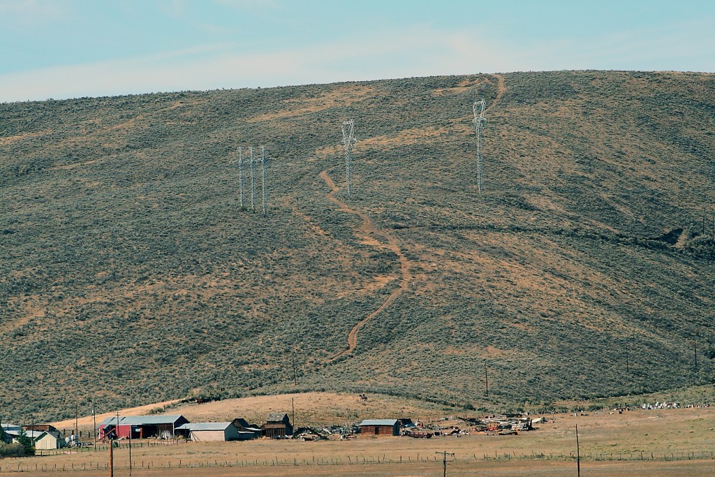
Just across the modern-day border of Wyoming and Idaho, Thomas Fork enters Bear River (GPS coordinates -111.067, 42.214). Emigrants would cross Thomas Fork while remaining on the north side of Bear River. There is an Idaho State Historical Marker located here and the photograph comes from the Historical Marker Database at https://www.hmdb.org/m.asp?m=90804. Dr. William Thomas (https://www.octa-journals.org/merrill-mattes-collection/diary-of-dr-william-thomas-1849), on June 27, 1849, wrote, “After travelling 3 miles further up the valley we crossed a small tributary (though large enough to cause us to block up our wagon beds) of Bear river. Here the road leaves the river (which passes through a canon in the mountains) and proceeds around, through, and over mountains, for the distance of 13 miles when it again strikes the river. Bear river valley is one of the most beautiful valleys the imagination can conceive of. It is some three miles wide, perfectly level, and covered with the most luxurient grass and beautiful flowers. High ranges of mountains are rising above another until they reach the clouds bounds it on either side presenting a most grand and magnificent scenery.”

July 28 – A 5-month virtual road trip along the California Trail
Emigrants had to make their way over a very large mountain between Thomas Fork and their descent back to Bear River and this became known as the “Big Hill” (GPS coordinates -111.134, 42.231). Highway 30 passes over this hill as you travel from the Wyoming border toward Montpelier. Eliza Ann McCauley (see a preview of her diary in the Best of Covered Wagon Women Volume 2 https://www.google.com/books/edition/Best_of_Covered_Wagon_Women/fQjjBAAAQBAJ?hl=en&gbpv=1) recorded on July 15, 1852, “Traveled ten miles today and camped on Bear River. Just before coming to the River we had the hardest mountain to cross on the whole route. It was very steep and difficult to climb, and we had to double teams going up and at the summit we had to unhitch the teams and let the wagons down over a steep, smooth sliding rock by ropes wound around trees by the side of the road. Some trees are nearly cut through by ropes. Rained a little this evening. Mosquitoes very bad. The boys fished awhile and then took a ramble around the country and discovered a pass, by which the mountain can be avoided by doing a little road building.” The photograph of Big Hill is from the National Park Service Historic Trails Auto Tour Book through Idaho (https://www.nps.gov/articles/000/auto-tour-route-interpretive-guides-california-trail.htm).
July 29 – A 5-month virtual road trip along the California Trail
The Big Hill (visited in yesterday’s virtual tour stop) and the alternate route around it are described in detail on several interpretive signs located at a pullout (GPS coordinates -111.233, 42.236) off of Highway 30 about 6.5 miles southeast of Montpelier. The Historical Marker Database (https://www.hmdb.org/m.asp?m=90852) describes 8 interpretive markers at this location. The alternate route around the Big Hill is called McCauley’s Road because of Eliza’s description of the road-building efforts of her traveling companions (see a preview of her diary in the Best of Covered Wagon Women Volume 2 https://www.google.com/books/edition/Best_of_Covered_Wagon_Women/fQjjBAAAQBAJ?hl=en&gbpv=1) – “July 16 (1852) – The boys took another look at the pass and concluded to stop and make a road around the mountain. July 18 – Notwithstanding it is Sunday, the boys continue their work and have hired some men to assist for a day or two, to cut brush… July 19 – In cutting a way for the road, the boys find thickets of wild currants… which we strip off and make into jelly, currant wine and vinegar, dried currants and currant pie. July 24 – Moved the camp up the River about three miles on the road and camped in a beautiful place on the river bottom. We have eight of nine hands today to work on the road. The boys want to get it finished to save people from having to cross that dreadful mountain and also that we may get away sooner.”

July 30 – A 5-month virtual road trip along the California Trail
Only a mile and a half further along Highway 30 from yesterday’s virtual stop you’ll encounter an Idaho Historical Marker regarding Smith’s Trading Post (GPS coordinates -111.256, 42.253). The Historical Marker Database at https://www.hmdb.org/m.asp?m=90805 has information about, and the accompanying photograph of, the marker. Benjamin Biddle (https://donduncan.org/trails/biddle.htm), on Wednesday, July 11th, 1849, described crossing the Big Hill and arriving at Smith’s Trading Post: “Had an early start. Ascended a very steep hill, a mile long. Very rough and hilly for four or five miles, and descended the steepest hill we have had yet, more than a mile long. All got down safe, and then looked back and wondered how. Next came to the river at a trading point, kept by a man they called Peg-leg Smith. Fine river bottom land—covered with luxuriant grass. In the afternoon, we crossed a number of streamlets, bearing their tribute from the masses of snow to Bear River. Encamped, to the right of the road, on a branch. Fine grass—willows for fuel. Distance of to-day s travel, 24 miles.”

July 31 – A 5-month virtual road trip along the California Trail
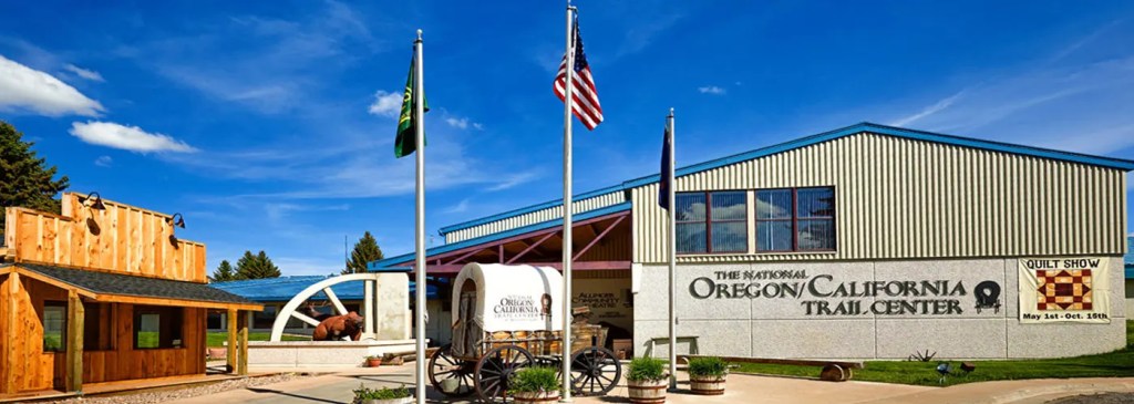
To finish out July, take a look at the National Oregon/California Trail Center (https://oregontrailcenter.org/) in Montpelier, ID (GPS coordinates -111.297, 42.323). The picture was downloaded from their website. The website describes the Center in this way: “The Center interprets the story of the pioneers who braved the arduous, six-month, 2,000 mile journey across the unsettled American West from Missouri to the Oregon Territory. The interpretation of this epoch migration is told using live actors within historically accurate interpretive areas located in the center. Visitors join a simulated wagon train headed west and experience what it was like to prepare for the journey. The Center also includes the Peg Leg Smith Trading Post gift shop, two sets of large and spacious public restrooms, the beautiful Allinger Community Theatre for viewing films and experiencing cultural/musical events, the Simplot art exhibit featuring the Oregon Trail paintings of Idaho artist Gary Stone, and the Rails and Trails Museum that highlights the heritage of the Bear Lake Valley as well as exhibits from the Bear Lake County Historical Society, Union Pacific and Daughters of Utah Pioneers.”
Samuel Murray Stover (https://www.octa-journals.org/merrill-mattes-collection/diary-of-samuel-murray-stover-1849) described the Bear River Valley here on July 22 and 24, 1849: “The Bear River Valley is clothed with the finest grass and would make fine hay. Wild rye and flax grow very luxuriantly. The immigrants seem to have brighter hopes and are more jovial. I have noticed that heretofore gloom seemed to be pictured on every countenance…. We are now in a region of rain and dew. The hills are clothed with fine grass and wheat. Passed a small village of Snake Indians, one or two traders with them. They had a great many fine horses and colts. They would trade them. Nooned at a small creek of good water and wood. Filled with fine mountain trout. Camped at a small creek near the hills. Fine grass and water. Sat up tonight to bake bread. Had just laid down to sleep when I was aroused by the clattering of hoofs and the cry of “stampede”. Got out as soon as I could and saw the last mule running as fast as he could. Followed them a mile where we came up with them all and took them back. Fastened them to the wagon.”