Continuing my virtual tour along the California Trail via social media posts for the California Trail Interpretive Center in Elko, Nevada, I bring you the first week’s travel for August.

August 1 – A 5-month virtual road trip along the California Trail
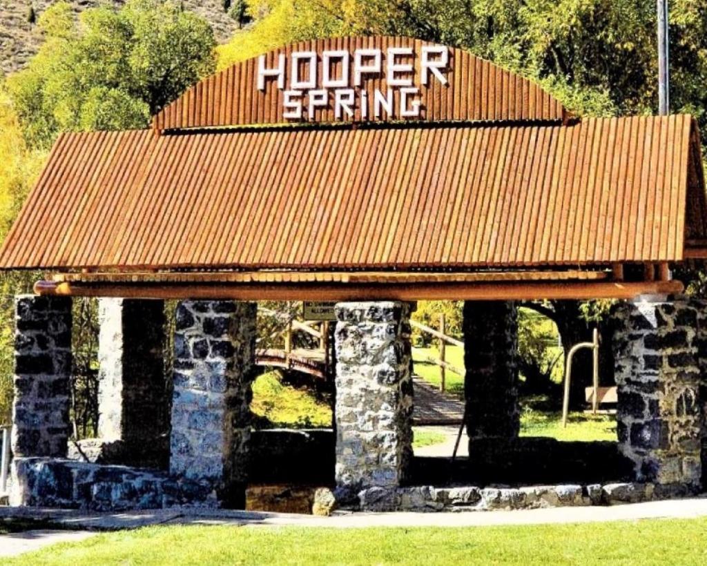
For the next week of our virtual road trip we’ll be hanging out in the vicinity of Soda Springs, Idaho. The first stop is at Hooper Spring (https://www.sodaspringsid.com/recreation/hooper_springs_park/index.php GPS coordinates -111.603, 42.679). This is a good place to experience (and even taste) the soda water that emigrants would have encountered in this area and for which the area was so well known. There are also several other parks in town which have springs and interpretive displays related to the Trail, including City Park, Geyser Park, and Octagon Spring Park. You’ll find links and descriptions at the website listed above, as well as the photograph which accompanies this post.
On July 13, 1850 Jerome Dutton (https://archive.org/details/acrossplainsin1800duttrich/page/468/mode/2up) wrote, “Today we came to the Soda, or Copperas springs. The first two were on the bank of a creek close to the river. The water gurgles up with a snapping noise and the first taste resembles soda, but the after taste is more like iron and very disagreeable. A little lower down and directly on the bank of the river is what is called the Steamboat spring. Through a hole in the rock about 18 inches in circumference it gushes up to a height, sometimes, of two feet. It makes considerable noise and foams something like soda. Like the other springs, it is of very unpleasant taste and smell.”
August 2 – A 5-month virtual road trip along the California Trail
Fairview Cemetery lies next to Geyser Park in Soda Springs, ID. There you’ll find an interpretive marker and a gravestone labelled the Wagonbox Grave (GPS coordinates -111.6063987499482, 42.65659692447328). The Historical Marker Database (https://www.hmdb.org/m.asp?m=106254) has information about the marker and gravestone, including the accompanying photograph. This was the first grave in the cemetery and it is accompanied by a tragic story, as related to Abraham C. Anderson by George W. Goodhart in Trails of Early Idaho, published in 1940. No electronic access is available. A wagon train had lost some horses and several parties went to look for them. One family with their wagon decided to remain in camp and look for the horses while the rest of the train moved on down the road. George Goodhart related that men who had been out seeking the horses returned to “bring our horses into camp. When they came back they told us they saw a lone emigrant wagon camped on Little Spring Creek at the old wagon crossing, so we caught our saddle horses and rode up there. We found that the emigrants had all been murdered.” Sending a message to another nearby wagon train, they got help with the task of caring for the victims and their belongings. Relating that they were found where “they had made their beds on the ground”, Goodhart describes their burial. Taking a discarded wagon box, they laid the “mother on the outside; the oldest boy next to her with his feet between the father and mother; the next smallest boy by the side of him, his feet up along the outside of his father; a little boy next to the baby we laid in about halfway up along the side of his father, with his head a little below his father’s hips. We then covered them all up with quilts and took the upper sideboards and sawed them so they would fit across the wagon box. We put some across over the old folks’ faces and some over the children’s faces at the foot. Then we got some willows from Soda Creek and cut them off so as to cover the whole length of the wagon box. We then spread quilts over them, covered them with dirt, and set four formation rocks, one at each corner. This grave is now in the Soda Springs cemetery. After the grave was nicely fixed we all decided that the emigrants should take the wagon, harness, and the horses, for we knew of no one any more entitled to them;”

August 3 – A 5-month virtual road trip along the California Trail
St. Mary’s Catholic Church is located just south of the cemetery described in yesterday’s post. There you will find a bust and four interpretive signs about Father Pierre De Smet (also discussed on our July 22 virtual tour post). This memorial (GPS coordinates -111.606, 42.656) is described on the Historical Marker Database at https://www.hmdb.org/m.asp?m=106775 and the accompanying photograph comes from that web page. De Smet was a part of the wagon train traveling the Oregon Trail in 1841. It was at this point that the Bidwell/Bartleson group broke off from the train and headed overland to California, becoming the first group of emigrants to make that journey.
John Bidwell (http://www.loc.gov/resource/calbk.046) wrote, “August 10 – Cedar grows here in abundance, and the scenery of the country is romantic. Father De Smet, with two or three flathead Indians, started about dark this evening to go to Fort Hall, which was about fifty miles distant. August 11 – Having traveled about six miles this morning, the company came to a halt. The Oregon company were now going to leave Bear river for Fort Hall, which is situated on Lewis River, a branch of the Columbia. Many, who purposed in setting out to go immediately through to California, here concluded to go into Oregon; so that the California company now consisted of only thirty-two men and one woman and child, there being but one family. The two companies, after bidding each other a parting farewell, started and were soon out of sight. Several of our company, however, went to Fort Hall to procure provision, and to hire if possible a pilot to conduct us to the Gap in the California Mountains; or at least, to the head of Mary’s River. We were therefore to move on slow till their return.”

August 4 – A 5-month virtual road trip along the California Trail
The Oregon Trail Park & Marina (GPS coordinates -111.654, 42.658) has a set of original trail swales that cross the entrance road to the Park. The National Park Service website (https://www.nps.gov/places/000/oregon-trail-park-and-marina.htm) and the Historical Marker Database (https://www.hmdb.org/m.asp?m=124577) both provide some descriptions of the swales and interpretive panel located there. The accompanying photograph comes from the HMDB site.
John Minto (https://www.jstor.org/stable/20609503?seq=4#metadata_info_tab_contents), on Sept. 5, 1844, relates a couple of stories from near here: “Late in the afternoon of that day I saw a fine contest between a falcon and a hare. I had started the latter near to the river. The hawk soaring near stooped with a swoop, but the hare squatted close to the ground; the bird rose then, and the hare ran till the hawk again swooped down, but the hare again doubled down, seeming to make itself into a small, round bunch. This was repeated four or five times, and bunny got to cover of some sage brush, and the falcon went off with an angry scream. I struck the road again in advance of my friends near Soda Springs. There was in sight, however, G. W. Bush, at whose camp table Rees and I had received the hospitalities of the Missouri rendezvous. Joining him, we went on to the Springs. Bush was a mulatto, but had means, and also a white woman for a wife, and a family of five children. Not many men of color left a slave state so well to do, and so generally respected; but it was not in the nature of things that he should be permitted to forget his color. As we went along together, he riding a mule and I on foot, he led the conversation to this subject. He told me he should watch, when we got to Oregon, what usage was awarded to people of color, and if he could not have a free man’s rights he would seek the protection of the Mexican Government in California or New Mexico. He said there were few in that train he would say as much to as he had just said to me. I told him I understood. This conversation enabled me afterwards to understand the chief reason for Col. M. T. Simmons and his kindred, and Bush and Jones determining to settle north of the Columbia. It was understood that Bush was assisting at least two of these to get to Oregon, and while they were all Americans, they would take no part in ill treating G. W. Bush on account of his color. No act as a legislator in 1846 was more creditable to him than getting Mr. Bush exempt from the Oregon law, intended to deter mulattoes or negroes from settling in Oregon – a law, however, happily never enforced.”

August 5 – A 5-month virtual road trip along the California Trail
Continuing west from Soda Springs along Highway 30 you’ll find the Sheep Rock Interpretive Site (GPS coordinates -111.702, 42.648). Here you’ll encounter 8 interpretive signs related to both Geology of the area and Trail History. All of these signs are linked from or described in the Historical Marker Database at https://www.hmdb.org/m.asp?m=106846, and the photograph comes from one of those links as well.
Explorer John C. Fremont (https://archive.org/details/expeditionsofjoh01fr/page/482/mode/2up) wrote on August 25, 1843: “Remaining in camp until nearly 11 o’clock, we travelled a short distance down the river, and halted to noon on the bank, at a point where the road quits the valley of Bear river, and, crossing a ridge which divides the Great Basin from the Pacific waters, reaches Fort Hall, by way of the Portneuf river, in a distance of probably fifty miles, or two and a half days’ journey for wagons.… But our little stock of provisions had again become extremely low; we had only dried meat sufficient for one meal, and our supply of flour and other comforts was entirely exhausted. I therefore immediately despatched one of the party, Henry Lee, with a note to Carson, at Fort Hall, directing him to load a pack horse with whatever could be obtained there in the way of provisions, and endeavor to overtake me on the river. In the mean time, we had picked up along the road two tolerably well-grown calves, which would have become food for wolves, and which had probably been left by some of the earlier emigrants, none of those we had met having made any claim to them; and on these I mainly relied for support during our circuit to the lake. In sweeping around the point of the mountain which runs down into the bend, the river here passes between perpendicular walls of basalt [Black Canyon], which always fix the attention, from the regular form in which it occurs, and its perfect distinctness from the surrounding rocks among which it has been placed. The mountain, which is rugged and steep, and, by our measurement, 1,400 feet above the river directly opposite the place of our halt, is called the Sheep rock— probably because a flock of the common mountain sheep (ovis montana) had been seen on the craggy point.

August 6 – A 5-month virtual road trip along the California Trail
If you turn south off Highway 30 (west of Soda Springs) onto Highway 34 you’ll see 3 interpretive panels on the west side of the road in about a third of a mile (GPS coordinates -111.730, 42.644). These panels are described on the Historical Marker Database at https://www.hmdb.org/m.asp?m=140278. It was down this valley that the Bidwell/Bartleson party separated from the rest of the Oregon-bound train and continued following Bear River south to the Great Salt Lake, and then turned westward to seek out California in 1841. The panels (shown in the photograph from the website above) discuss the separation and path of the emigrants. See the August 3 post for Bidwell’s comments about that.
In his memoir California in ’41 (no available electronic access) Nicholas “Broken-Hand” Dawson related a version of a story told by Bidwell: “While we were traveling down Bear river, the “snow incident” related by Gen. Bidwell in an article in the Century Magazine some years ago, occurred. Bidwell and Jimmy Johns had gone off fishing. They did not return, and much anxiety was felt. At midnight the guard reported that they had not come in. Then the camp was aroused, the wagons were corralled, and everything ready, we awaited a daybreak attack – for that was the Indians’ time. We were sure that Bidwell and Johns had been killed, and we expected to have to fight for our own lives. Daybreak at last came, but no Indians. Later in the day, we decided to send out parties to search for the bodies of our comrades. I was riding along, looking for Indian signs and gory corpses, when I saw two men running down a mountain. When they came nearer, I saw that it was the supposed dead. As soon as Bidwell was within hearing, he triumphantly held up a handkerchief full of something and shouted, “Snow!” Then I spoke forcibly. “Snow! –! –! We thought you were dead.” They had seen a snow-summited mountain a short distance, as they thought, ahead of them, and had set out for it. They had traveled all day, reaching it a little before night. They had climbed and climbed until they got so cold that they had to stop and build a fire to keep from freezing. When morning came they had reached the prize, got a handkerchief full of it and hurried back.”

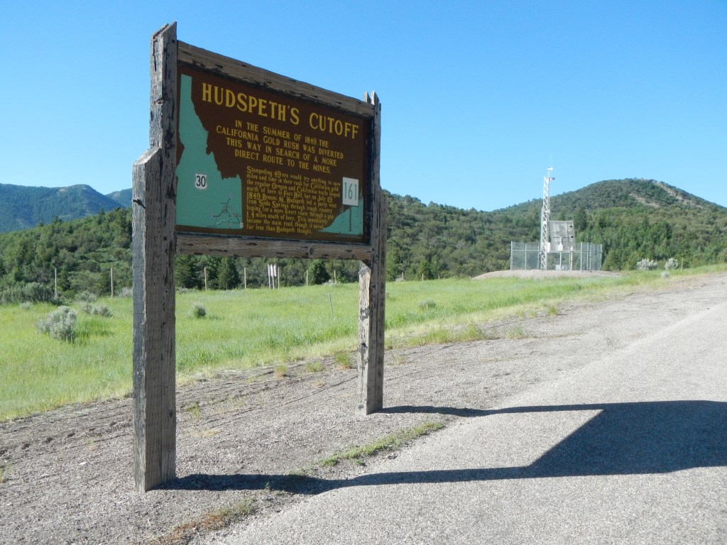
August 7 – A 5-month virtual road trip along the California Trail
Hudspeth’s Cutoff was developed to “cut-off” the loop up to Fort Hall and reconnect with the main California Trail near City of Rocks. Highway 30 follows the approximate route of about the first third of the cutoff. You’ll see an Idaho historical marker (GPS coordinates -111.917, 42.630) along that route. The Historical Marker Database has the accompanying photograph at https://www.hmdb.org/m.asp?m=106774.
Joseph Sedgley (https://babel.hathitrust.org/cgi/pt?id=njp.32101074863992&view=1up&seq=48&skin=2021) described taking the cutoff on July 28, 1849: “Morning cool. Two miles brought us to the forks of the road. The river turns to the left; the Fort Hall road—to Columbia River- to the right, while the cut-off goes straight ahead. We take the latter. Several cards, which we here find in a stick, denote that parties have passed here before us. The first twelve miles is over an incline plain; then the road runs across some hills, between two mountain ridges; then, by a circuitous route, around the mountain; and then descends into a valley, where there is a stream of pure, spring water, good grass and wood. In the afternoon, we ascended a long hill, and, at the end of three miles, found good water. Two miles further, over some rocky hills, there is another stream of good water. Three miles more, across the hills, and we camped, at six, with plenty of grass and wood. Distance, twenty-seven miles. Copperheads and rattlesnakes are numerous.”