Here is a continuation of my posts regarding a virtual road trip along the California Trail, posted on the Facebook page of the California Trail Interpretive Center.
July 1 – A 5-month virtual road trip along the California Trail
Continuing down the road from Poison Spring / Clayton’s Slough (yesterday’s virtual site) is Willow Spring (GPS coordinates -106.794, 42.674). This was a much better water source than that one and was a popular camping location. For more information, visit the Wyoming Historical Society at https://www.wyohistory.org/encyclopedia/willow-spring. The photo was downloaded from this site.
An anonymous diary in the collection of OCTA identified as the Fayette County Boys had the following entry for July 3, 1850: “This was one of the hardest days we have had since we started our trip. We now had neither grass or water and the sides of the road were strewn with dead horses and cattle that had been drinking alkali water. To-day I talked with an old man who started with a family of seven, and five out of that number had died and left him with a little boy ten years old. They had two teams to manage and the old man was trying to get someone to help him, but could not. Utter dispair was depicted in every furrow in the old man’s face, but I thought from his appearance that he would not be troubled long in this world, and if all is right with him in the next, the sooner he was off the better it will be for him. We encamped in Willow Springs.”

July 2 – A 5-month virtual road trip along the California Trail
A little over a mile further down the road from Willow Spring is a BLM interpretive pullout that describes Prospect Hill (GPS coordinates -106.810, 42.660). The road climbed about 400 feet in the space of a mile and presented a pretty difficult climb for the emigrants. But they were greeted at the top with a sweeping vista of distant mountains. You can read more about Prospect Hill at the Wyoming Historical Society page at https://www.wyohistory.org/encyclopedia/prospect-hill. The photograph was downloaded from that site.
Many women’s diaries from the trail are published in the Covered Wagon Women series of books (which are available for purchase in the California Trail Interpretive Center gift shop). One of these – the Best of Covered Wagon Women, Vol. 2 – can be previewed at https://www.google.com/books/edition/Best_of_Covered_Wagon_Women/fQjjBAAAQBAJ?hl=en&gbpv=1). On June 8, 1854 Mary Burrell wrote, “Delightful day. Passed some graves & climbed Prospect Hill; got tired before I reached the top & hung on to Isaac’s coat tail Camped at noon near a wide stream clear as crystal. Put washed my head. Reached the Sweet Water at night near Independence Rock. Oh, yes, saw a lake of Alkali all crusted over like a frozen pond with Saleratus some of which we gathered.”

July 3 – A 5-month virtual road trip along the California Trail
Steamboat Lake (GPS coordinates -107.080, 42.550), and other lakes close to it, were encountered by the emigrants as they made their way toward the Sweetwater River. These lakes are very alkaline and you can learn more about them at https://www.wyohistory.org/encyclopedia/saleratus-lake. The accompanying photograph was downloaded from that site. Emigrants noted the prevalence of “saleratus”, or sodium bicarbonate, in the west and both enjoyed the use of it in cooking and dreaded the effects from drinking water tainted with it on their livestock.
On June 21, 1847 William Clayton (https://www.gutenberg.org/files/45051/45051-h/45051-h.htm) described these lakes: “After traveling three and a quarter miles we arrived on a bed of saleratus which was a quarter of a mile across and on which were several lakes of salt water. This place looks swampy and smells bad. The beds of saleratus smell like lime, but the saleratus itself is said to raise bread equal to the best bought in eastern markets. Lorenzo Young gathered a pail full in a short time with a view to test its qualities. Large quantities may be gathered in a short time and when pulverized it looks clean and nice. We are now satisfied that the water we saw from the hills yesterday must have been some of these lakes as the Sweet Water is not yet in sight, but these being high, show at a long distance. The water is not very salty but brackish and tastes sickly. It is reported by travelers that these are poisonous, but it is probable that all the poison there is about them is their salt causing cattle to drink freely when they can get no other water, and the more they drink, the more thirsty they get till they burst themselves, which is said to be the effect of drinking the poison, viz., to burst. As we passed along a little farther we saw another large lake to the left and one to the right of the same nature, their banks mostly white with saleratus. At twelve o’clock we arrived on the banks of the Sweet Water, having traveled seven and a half miles over a very sandy road destitute of wood, water or grass. The distance from the upper ferry of the Platte river to this place is forty-nine miles by the roadometer.” You can see Clayton’s original handwritten journal at https://catalog.churchofjesuschrist.org/assets/2f057642-483b-4112-a67f-8ecc13f69d28/1/174.

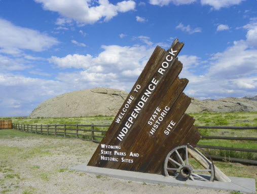
July 4 – A 5-month virtual road trip along the California Trail
Tradition tells us that Independence Rock (https://wyoparks.wyo.gov/index.php/places-to-go/independence-rock GPS coordinates -107.132, 42.494) received its name from William Sublette and a party of fur trappers in 1824 when they celebrated Independence Day at this location. The granite monolith was a frequently mentioned landmark on the Trail and many thousands of emigrants left their names painted or inscribed on the rock. The accompanying photograph comes from the website listed above. You might also find the Wyoming Historical Society description interesting that is found at https://www.wyohistory.org/encyclopedia/independence-rock.
You can download and read Gilbert Cole’s description of his travels along the Trail at (https://www.google.com/books/edition/In_the_Early_Days_Along_the_Overland_Tra/ikVVRYxBaVwC?hl=en&gbpv=0). In chapter six he wrote, “When making up our outfit back in the States, by oversight or want of knowledge of what we would need, we had neglected to lay in a supply of horse-nails, which we now began to be sorely in need of, as the horses’ shoes were fast wearing out and becoming loose. It was just here that we came one day to a man sitting by the roadside with a half-bushel measure full of horse nails to sell at the modest price of a ”bit” or twelve and one-half cents apiece. No amount of remonstrance or argument about taking advantage of one’s necessity could bring down the price ; so I paid him ten dollars in gold for eighty nails. I really wanted to be alone with that man for awhile, I loved him so. He, like some others who had crossed the plains before, knew of the opportunity to sell such things as the trailers might be short of at any price they might see fit to ask. It was here, too, that we came upon the great Independence Rock, an immense boulder, lying isolated on the bank of the Sweetwater River. It was oblong, with an oval-shaped top, as large as a block of buildings. It was of such form that parties could walk up and over it lengthwise, thereby getting a fine view of the surrounding country.”
July 5 – A 5-month virtual road trip along the California Trail
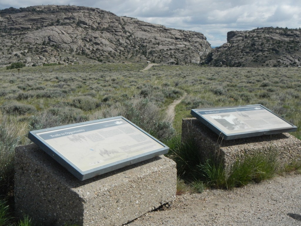
The California/Oregon/Mormon Trail did not pass directly through Devil’s Gate because it was so narrow, but skirted south of it around the rocky ridge through which the Sweetwater had downcut. However, the site was a very popular curiosity. There is a pullout (GPS coordinates -107.218, 42.437) constructed by the Bureau of Land Management in which you can view some interpretive signs and walk a short trail to view the feature. The photograph was downloaded from the Historical Marker Database at https://www.hmdb.org/m.asp?m=95488.
Alonzo Delano (https://archive.org/details/lifeonplainsamon01dela/page/98/mode/2up), on June 23, 1849, wrote, “About fifty rods below the mouth of the gap, a curiosity indeed presented itself. The river has apparently broken through the mountain, and passes through a chasm of perpendicular rock, probably over three hundred feet high. It was evidently done by volcanic force, for the blackened, burnt rocks which lay around, and a dyke of black trap rock which had been forced up in the granite on the right wall, showed that it had been subjected to intense heat. The river flowed through this singular chasm nearly a quarter of a mile, quite through the mountain, when it again entered the valley which we had just left. At the base of the wall we found the remains of a 100 mountain sheep, or ibex, which had probably been driven off from the top by the wolves; but his strong horns and stiff neck were not staunch enough to protect his life against such a force. Sam Patch himself, the prince of jumpers, would hardly have ventured his carcass in mid air from this wall. There were large quantities of yellow mica in the stream, and as it was determined to turn everything into gold that was possible, some of our boys insisted that this was ore, but an application of nitric acid instantly dispelled the pleasing hallucination, and proved that Sweet Water valley was not the valley of the Sacramento. Large masses of saleratus, several inches thick, and very pure, were found on the plain around, and it is not necessary for the emigrant to lay in a supply of this useful article any farther than to this point. The singular chasm which the Sweet Water passes through, has not inaptly acquired the soubriquet of Devil’s Gate, and it did seem as if his Satanic majesty had been cutting queer antics in this wild region.”
July 6 – A 5-month virtual road trip along the California Trail
Two late-season groups of Mormon settlers (the Martin group and the Willie group) were heading for Salt Lake City in 1856. Martin’s Cove and the Mormon Handcart Visitor Center (GPS coordinates -107.218, 42.442) are good places to visit to learn the story of their trials. The visitor center complex website is https://www.churchofjesuschrist.org/learn/historic-sites/wyoming/martins-cove?lang=eng and the accompanying photograph came from that site. You can also read about the groups at the Wyoming Historical Society’s site at https://www.wyohistory.org/encyclopedia/martins-cove-controversy.
No journals were kept by the Martin Handcart company, but excerpts from journals of the Willie company can be downloaded at https://familysearch.org/patron/v2/TH-301-46171-171-82/dist.pdf?ctx=ArtCtxPublic. It was near Martin’s Cove that a Willie company journalist wrote (on October 15, 1856): “Early this morning, Caroline Reeder, from Linstead, Suffolk, England, aged 17 years, died. The camp rolled on, passed ‘Devil’s Gate’ & nooned after travelling about 6 miles. The camp rolled on & we camped on the banks of the Sweetwater after making about 16 miles travel thro’ the day. Many of the company are sick & have to ride in the wagons. One beef heifer & one poor cow were killed this evening for the camp. Last evening a council & a meeting were held to take into consideration our provisions & the time it was considered we should have to make it last before we could depend upon supplies. It was unanimously agreed to reduce the rations of flour one fourth – the men then would get 10 1/2 ozs. per day; women & large children 9 ozs. per day; children 6 ozs. per day; & infants 3 ozs. per day each.”

July 7 – A 5-month virtual road trip along the California Trail
There are two pullouts (GPS coordinates -107.546, 42.453 and -107.604, 42.473)with interpretive signs and markers in the vicinity of Split Rock, a landmark on the Trail. The photograph is from Google Maps Streetview. You can read about Split Rock at the Wyoming Historical Society website at https://www.wyohistory.org/encyclopedia/split-rock.
It was somewhere near here that Hamilton Scott (https://www.octa-journals.org/merrill-mattes-collection/diary-of-hamilton-scott-1862) related an interesting story about trail justice, from 1862: “July 6 – Drove about twenty five miles; No grass at noon. At four o’clock P.M. passed two trains camped who informed us of a murder committed near them today. Two men quarrelled about a team, one shot the other, took his team and money. We travelled late, found no grass; cattle suffering for feed. July 7 – Started at sun rise travelled four or five miles and found grass on river bottom. Several trains were camped here so we drove in and camped too. We are informed that the murderer is camped here. By request of some men from another camp, Captain Kennedy of our train ordered out twenty men well armed to surround and take him which they did. With court organized and a jury of twelve men selected, he was given a fair trial and a twelve to one verdict guilty of willful murder. The prisoner kept under guard, we hitched up at two p.m. and drove eight miles. Grass and water good. A large train was camped here. Captain Kennedy called their whole company together and laid the case before them. They decided that the prisoner be executed tomorrow morning. July 8 – Gave prisoner his choice to be shot or hanged. He preferred to be shot. Twenty five armed men marched him one half mile to where his grave had been prepared. Fourteen of the guns were loaded with bullets and the rest were blanks. When the signal was given they all fired the prisoner falling backwards and dying within one minute. It was a sad sight to look upon. We immediately laid him in his grave without even a rough box. As soon as our work was completed we moved on toward the setting of the sun. Drove twelve and camped on the river.”

