June 22 – A 5-month virtual road trip along the California Trail
3-year-old Ada Magill died from dysentery on July 3, 1864. You can read her story on the Wyoming History webpage of the Wyoming State Historical Society at https://www.wyohistory.org/encyclopedia/ada-magill-grave.
The photograph of her gravesite (GPS coordinates -105.978,42.849) was downloaded from the Historical Marker Database at https://www.hmdb.org/m.asp?m=92079. The Wyoming State Historical Society website (https://www.wyohistory.org/encyclopedia/graves-martin-ringo-and-jp-parker) also tells the story of Martin Ringo, whose grave is on private land not far from Ada’s. Unfortunately, death of a loved one was a common experience along the Trail. It was near this spot that Mary Ringo, whose journal can be read in the Library of Congress at (https://www.loc.gov/resource/gdclccn.56014477/?sp=36&r=0.281,0.624,0.857,0.357,0), lost her husband and recorded the event in her journal on July 30, 1864: “And now Oh God comes the saddest record of my life for this day my husband accidentally shot himself and was buried by the wayside and oh, my heart is breaking, if I had no children how gladly would I lay me down with my dead – but now Oh God I pray for strength to raise our precious children and oh – may no one ever suffer the anguish that is breaking my heart, my little children are crying all the time and I – oh what am I to do. Every one in camp is kind to us but God alone can heal the breaking heart. After burying my darling husband we hitch up and drive some 5 miles. Mr. Davenport drove my mules for me and Oh, the agony of parting from that grave, to go and leave him on that hillside where I shall never see it more but thank God tis only the body lying there and may we meet in Heaven where there is no more death but only life eternally.”

June 23 – A 5-month virtual road trip along the California Trail
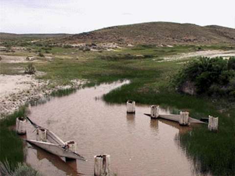
In the winter of 1852-1853, John Richard (pronounced Reshaw) built a bridge across the North Platte. Emigrants would soon be leaving the North Platte en route to follow the Sweetwater and they needed to be on the north side of the river. A replica of the bridge (that doesn’t span the river) can be viewed at Reshaw Park (GPS coordinates -106.267,42.870) in Evansville, WY. The photograph was downloaded from the Historical Marker Database at https://www.hmdb.org/m.asp?m=92052.
John Murray wrote on June 9, 1853: “The bridge is a substantial structure – it has 8 wood framed piers filled & sunk with rock & the reaches are supported by heavy braces. The sides are railed up & bottom planked. The bridge is about 150 yards long & comes out this side (north) on a high rocky bank… At each end of the bridge are Indian lodges and trading houses & a blacksmith shop. Above the bridge a mile is another trading post where they have lots of horses and mules to sell or trade.”

June 24 – A 5-month virtual road trip along the California Trail
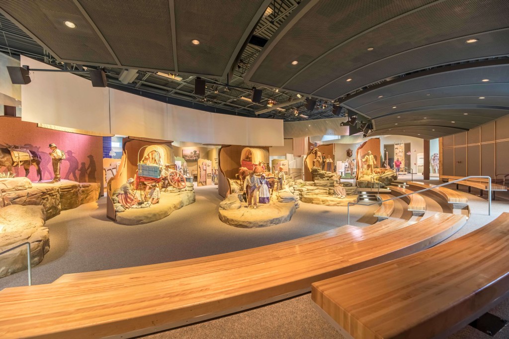
The National Historic Trails Interpretive Center in Casper, Wyoming is a “sister” facility to the California Trail Interpretive Center in Elko, Nevada. Along with the Oregon Trail Interpretive Center in Baker City, Oregon these three Bureau of Land Management Centers focus on the stories of the westward migration. The NHTIC (https://nhtcf.org/ GPS coordinates -106.337, 42.866) provides interpretation about all four trails that pass through this point: the California Trail, Oregon Trail, Mormon Trail, and Pony Express. The picture came from their website.
On June 28, 1850 Madison Berryman Moorman (https://babel.hathitrust.org/cgi/pt?id=uc1.32106000651817&view=1up&seq=51&skin=2021) described the territory covered during the last few days of our virtual road trip: “Nine miles from camp in the morning we came to Deer Creek where a large number of emigrants were encamped. The grass was not very good, but it being a cool, pleasant looking place, there being large, beautiful trees densly covering the broad bottom of the creek, we concluded to stop and wait for Dr. Thomas and J. W. W., who were behind with a jaded mule. The latter had to stop the evening before in consequence of its refusing to travel & did not get up with the train. After spending two hours in fishing etc., they came up with the mule much improved. Ten miles from this place we came to Crooked Muddy Creek, one of the most difficult & trying places to pass I ever saw. The banks were very steep & muddy—but caution, good teams & luck brought us over safely. Six miles more and we were at Muddy Creek, (& never was anything more appropriately named, for the water has the appearance of being near one half mud, rushing down the steep hill side into the Platte.) After having seen evidences of no little distress caused by the breaking down of wagons, which were left, deserted, & for want of them no inconsiderable amount of clothing & sundry articles were cast away. The rough road had broken one of the spindles of our axles, and fortunately we picked up wheels & axles that just suited. This was some good luck for our side.—For the first time I nodded as I rode along, it being irresistable in the melting sun. All well & in fine spirits.”
June 25 – A 5-month virtual road trip along the California Trail
Also located in Casper, Wyoming is the Fort Caspar museum (https://www.fortcasparwyoming.com/fort_caspar_museum GPS coordinates -106.370, 42.837) which has a reconstructed military post that was near the ferry crossing of the North Platte river. In addition to the Museum building and reconstructed fort, the Museum includes a reproduction Mormon ferry and Guinard bridge section, a carriage shed with open storage of the wagon collection, river trail, and memorial cemetery. The photo comes from their website.
Margaret Frink (https://babel.hathitrust.org/cgi/pt?id=njp.32101079825640&view=1up&seq=1) described this crossing of the North Platte river in 1850: “Sunday, June 16 – We remained in camp at this place all day. A great many emigrants are gathered here and above, preparatory to crossing the river. The water is too deep to ford and the ferry charges are very high. Some are making ferry-boats of their wagon bodies taken off the wheels, and launched in the water, with long ropes to haul them back and forth across the river. In some cases, empty casks are tied to the four corners of the wagon body, to keep it from sinking. This plan is very dangerous in the swift current, and we hear of many persons who have lost their lives in these attempts. Monday, June 17 – A great crowd was waiting to cross the ferry. But by starting early, we were not delayed, and got over by six o’clock. This ferry was established by Kit Carson, the famous hunter and trapper, one of Fremont’s guides. There were several ferry- boats. The water was deep and swift. The boats were attached to strong ropes stretched across the river, and were driven quickly from shore to shore by the strong current. We paid $5.00 each for our two wagons, and $1.00 each for our seven horses. The Platte River at this place comes out of the mountains from the southward, making a sharp bend at the ferry.“

June 26 – A 5-month virtual road trip along the California Trail
There is an interpretive sign pull-out (GPS coordinates -106.452, 42.815) off of highway 257 leading southwest from Casper. The photographs were downloaded from Google Maps Streetview at https://www.google.com/maps/place/Oregon+Trail+Historical+Markers/@42.815086,-106.4527925,184m/data=!3m1!1e3!4m5!3m4!1s0x8760a78eb318fd3d:0x8b0131c110f4cfd8!8m2!3d42.815086!4d-106.4522453. The pullout has many interpretive signs, regional views, and ideas for further local Trail exploration.
Mary Jane Guill (https://www.octa-journals.org/merrill-mattes-collection/the-overland-diary-of-a-journey-from-livingston-county-missouri-to-butte-county-california-mary-jane-guill-1860) described the stretch of road leaving the Platte river behind. On July 3, 1860 she wrote, “Cool this morning Shawl comfortable Move at 1/2 after six. Travell about 4 miles and bid farewell to the Platte river and strike across to sweet water. here we have an stretch of 18 miles. not entirely destitute of water either, because there is plenty of alkali here to much for the good of stock We see ever now and then a cowbrute that had been alkalied Traveled 25 miles to day to get to water very nice gravelly road to day. but it is hard on the cattles feet. to night we have camped at the willow springs. a very nice place and tolerable good grass considering that it has been camped on so much still it affords some yet. There is several nice springs here good cold water.”

June 27 – A 5-month virtual road trip along the California Trail
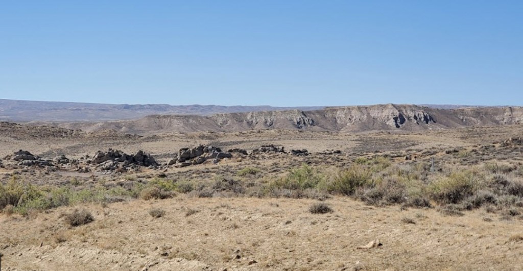
Emigrant Gap (https://www.wyohistory.org/encyclopedia/emigrant-gap) is another local site that emigrants passed through as they left the North Platte behind. The photograph was downloaded from this website.
John Hawkins Clark (https://babel.hathitrust.org/cgi/pt?id=uc1.31822035077213&view=1up&seq=39&skin=2021) wrote about commencing this part of the journey on June 15 and 16, 1852: “From this point to the topmost heights of the Rocky mountains is our next stage of travel; the road takes immediately to the high lands. We go up, up, up; for seven long miles, a dreary, desolate region, innocent of any kind of vegetation that can in any way be made available for food for our hungry teams; this is called “rattle-snake hill,” but why so called I am unable to say; we saw none; it would be very hard on the snake if he was obliged to make this hill a home. After traveling eight or ten miles the road becomes crooked, rough and flinty; the face of the country a broken mass of natural ruins; colonnades of stone from four to twenty feet in height, and six to ten feet square, dot the earth in a straight and continuous line for miles. What freaks in nature, or what time in the world’s past history these rocks had been so placed, would be hard for the average California pilgrim to determine.

June 28 – A 5-month virtual road trip along the California Trail
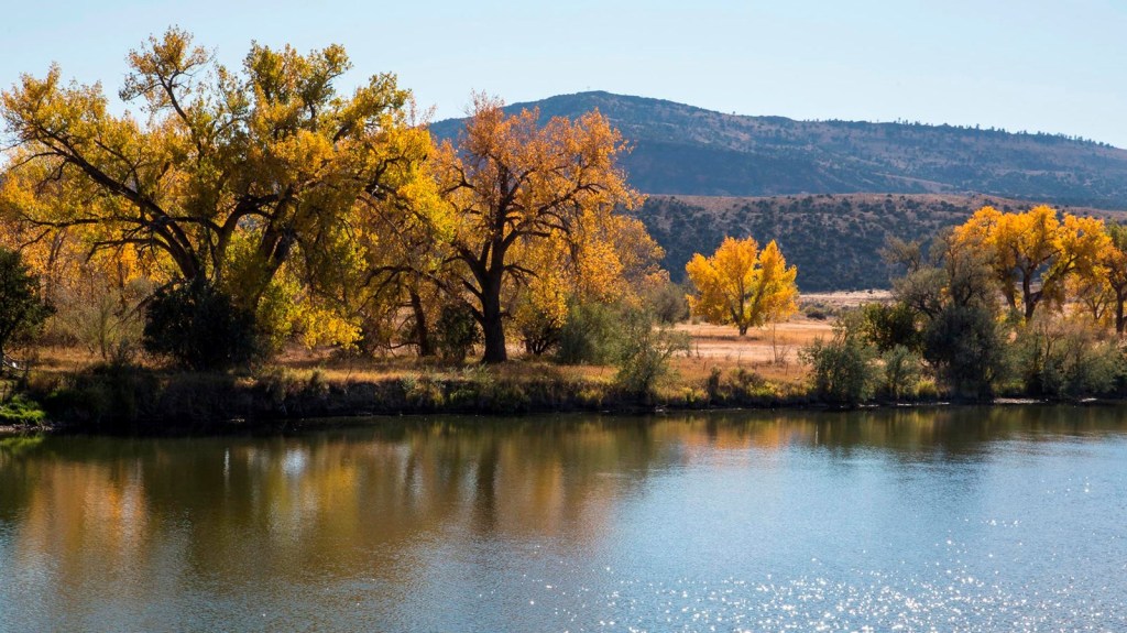
Bessemer Bend National Historic Site (https://www.nps.gov/places/000/bessemer-bend-national-historic-site.htm GPS coordinates -106.530,42.774) is a point a bit further up the North Platte river where some emigrants would ford the river. The photograph is from the website listed above. There are several interpretive signs and a picnic area at this location. This is also a viewpoint for observing the Red Buttes on the south side of the river – an oft-mentioned landmark along the Trail.
William Carter (https://archive.org/details/annalsofwyom11141939wyom/page/100/mode/), on his way to becoming head storekeeper at Fort Bridger and later one of territorial Wyoming’s most prominent politicians and landowners, wrote in 1857: “The Red Buttes which are tall hills of red sand and stone, on each side of the Platt, serve as the corner of the territories of several tribes of Indians, who often meet here on their hunting expeditions — The Cheyennes and
the Arapahoes (a number of whom we saw at Rishaws) owning the south side of the River The Sioux owning the north of the River up as high as the Red Buttes and the Crows and Snakes west of them.”
June 29 – A 5-month virtual road trip along the California Trail
The National Park Service Auto Tour Guide Across Wyoming (https://www.nps.gov/articles/000/auto-tour-route-interpretive-guides-california-trail.htm) describes Avenue of Rocks (GPS coordinates -106.662, 42.741) as “a jagged spine of rock jutting out of the otherwise rolling rangeland. Wagons wound their way through the formation, which [some] emigrants nicknamed “The Devil’s Backbone.” There are no interpretive signs, but wagon ruts are clearly visible. This is state-owned land, so get out and explore! Watch your step, though – this is rattlesnake and cactus country.” The photo is from Google Maps Streetview. The Wyoming State Historical Society also describes the area at https://www.wyohistory.org/encyclopedia/rock-avenue.
On July 23, 1849 J. Goldsborough Bruff wrote, “Latter part [of day’s journey] smooth firm road, with fine sand stone and indurated clay. Fortunely for us the weather is cool, with a strong breeze from the N.W. as all the intermedial watering places are dry. – Passed through a very singular defile, called “Rock Avenue” about 50 ft. wide, and some 200 long. As the Mineral Springs were supposed to be poisonous, I would not allay the mule’s thirst at the risk of their lives, and they suffer much. After emerging from the Defile, the road descended a very steep hill (had to double lock the wheels), here a wagon broke the fore-axle, and 4 of the mules exhausted; so they had to camp on a barren waste till morning, without feed [for animals] or water. At base of these hills was the “Alkali Swamp & Spring,” 2 miles from the Defile, and 7 ½ from the Mineral Spring. The water here – strong ley, was the color of coffee. And piled around were hundreds of dead animals, chiefly oxen. Ox geering lay about in profusion.” This quote is from Bruff’s edited and published diaries. The original handwritten diary entry can be viewed on page 92 of https://collections.library.yale.edu/catalog/2112234.
June 30 – A 5-month virtual road trip along the California Trail
About 2 miles further west of the Avenue of Rocks (yesterday’s virtual tour stop) lies Poison Springs, also known as Clayton’s Slough (https://www.wyohistory.org/encyclopedia/claytons-slough GPS coordinates -106.680, 42.721). The photo comes from this website. There are no interpretive signs here but white markers indicate the location of the Trail. When Mormon Pioneers left their Winter Quarters in 1847, Brigham Young appointed William Clayton (https://www.gutenberg.org/files/45051/45051-h/45051-h.htm) as one of the historians for the journey to Salt Lake Valley. On Saturday, June 19, 1847 he wrote, “At 7:40 we formed our encampment in a small spot surrounded by high bluffs, having traveled this afternoon ten and a quarter miles and during the day twenty-one and a half which is the longest distance we have traveled in one day since we left Winter Quarters, and this is considered by all to be the worst camping ground we have had on the journey, but we were obliged to take it for there is neither wood, grass, nor water since we left the spring. The land being perfectly sandy and barren, and nothing growing but wild sage and a small prickly shrub something like those on the moors in Lancashire, England. There is some grass in this place for our teams but no wood. The brethren have to make use of the wild sage and buffalo chips to do their cooking. There are two small streams of water, one appears to come from the northwest and is not very bad water; the other is from the southwest and is so bad that cattle will not drink it. It is strong of salt or rather saleratus and smells extremely filthy. Its banks are so perfectly soft that a horse or ox cannot go down to drink without sinking immediately nearly overhead in thick, filthy mud, and is one of the most horrid, swampy, stinking places I ever saw. It was found necessary to keep a guard out to prevent the cattle from getting into it and orders were given to drive them down a little east where feed is pretty good and it is not so dangerous of their miring. The mosquitoes are very bad indeed at this place which adds to the loathsome, solitary scenery around. Porter Rockwell returned from hunting soon after we had camped and reported that he had killed a fat buffalo about two miles off. A team was sent to fetch in the meat which they did not return till long after dark. Elder Kimball saw six buffalo while riding ahead to look out a camp ground. They are represented as being more tame. Myers killed two buffalo, but took only the tallow and tongues and left the rest to rot on the ground. John Norton and Andrew Gibbons left the camp at the springs and went out to hunt, expecting we should stay there till Monday. Gibbons has not been seen or heard of since. Norton has returned and reports that he has killed a buffalo and left it back not far from the spring. About nine o’clock there was an alarm that an ox had mired. He was nearly covered but soon got out again.”