
June 15 – A 5-month virtual road trip along the California Trail
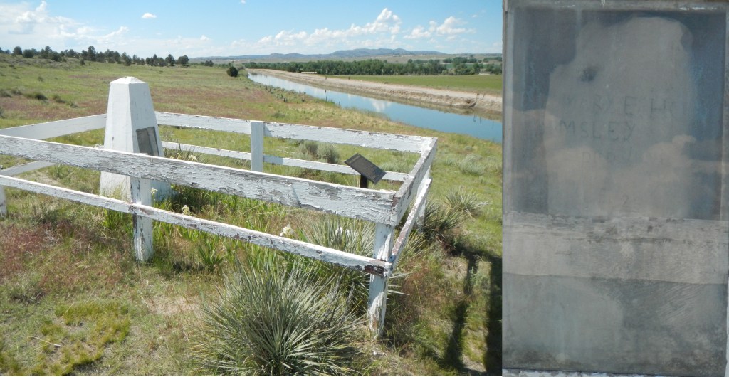
The grave of Mary Homsley (https://www.wyohistory.org/encyclopedia/grave-mary-homsley) is located close to Fort Laramie (GPS coordinates -104.566,42.222). While cholera was a predominant killing disease during the Overland migration in 1852, there were plenty of other dangerous diseases as well. Mary Homsley and her newborn child succumbed to measles near Fort Laramie. The photographs of the gravesite and the original sandstone marker were downloaded from the Historical Marker Database at https://www.hmdb.org/m.asp?m=98361.
Mary’s daughter, Lura, reminisced on the trip in an Oregon Journal article published August 12, 1932 and reprinted in the book Conversations with Pioneer Women in 1993 (no electronic access available). She wrote, “My father and mother, with us three younger children, started from our home in Missouri with two wagons drawn by oxen for the Willamette Valley. My mother and the baby died at Laramie, Wyoming, of the measles. They were buried by the side of the road. When Father buried Mother he found a piece of sandstone. With his jackknife he scratched deeply on this sandstone this inscription: ‘Mary E. Homsley, died June 10, 1852, aged 29’. I lost all track of Mother’s grave and supposed that the site of her grave had either been built over or plowed up, but 73 years after Mother was buried, Dr. Grace Raymond Hebard, professor of history at the University of Wyoming, wrote me a letter saying that the Wyoming Historical Society had put up a monument over Mother’s grave and that at the services more than 500 people were present, that the mayor of Laramie, Wyoming, was in charge, and that Mother’s grave had been banked with flowers.”
June 16 – A 5-month virtual road trip along the California Trail
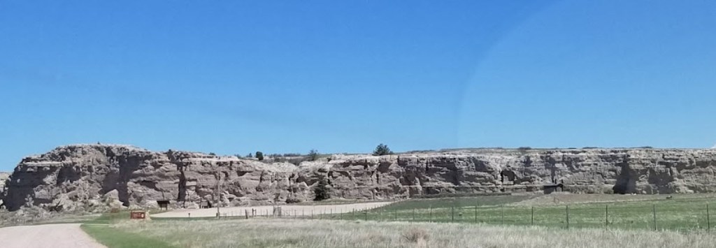
Register Cliff (GPS coordinates -104.712, 42.248) near Guernsey, Wyoming is managed by the Wyoming State Park system. As their website (https://wyoparks.wyo.gov/index.php/places-to-go/register-cliffs) says, “during the peak of the westward movement of the 1840’s and 1850’s, Register Cliff was an important landmark along the California, Oregon and Mormon trails. Situated a day’s travel west of Fort Laramie, the Register Cliff area was an important stopover and resting area for weary travelers to set up camp, to rest, and to pasture their animals.” You can watch a short introductory video at https://www.youtube.com/watch?v=o1jGd3tYEuc&t=1s and you can see a compiled list of identified names from the cliff at https://uwdigital.uwyo.edu/object/wyu5465.
On June 1, 1849 Joseph Berrien (https://scholarworks.iu.edu/journals/index.php/imh/article/view/8751) wrote about this area. “Left our camp about 7 and shortly after commenced ascending the Black Hills as they are called though they are any thing but black. We ascended and descended some very steep Hills on which we found very good grass but neither water or timber and it was not untill 3 o’clock in the afternoon that we found any. At this time we came to a fine spring of water at the foot of a Bluff in a sandy ravine 1/2 a mile distant from the road where we watered our thirsty mules and then proceeded onwards. The road with the exception of some few sandy gullies and some very long tedious Hills was very fine and equal to the best gravel road in the states. Campd at night on the Banks of a shallow creek calld Dry timber Creek, where we found plenty of wood and water but indifferent grass. The Hills and Bluffs during a portion of this days journey were very pretty and romantic in the extreme in their appearance. They are composed of a chalky rock resembling rotten stoni in appearance and are dotted over here and there, with scattering pine trees, the plains at the Base of the Bluffs are coverd with fragments of their Branches, which furnish splendid fuel for camping purposes. The country is quite barren generally though occasionally we found good grass, and a scarcity of water is felt on the road.”
June 17 – A 5-month virtual road trip along the California Trail
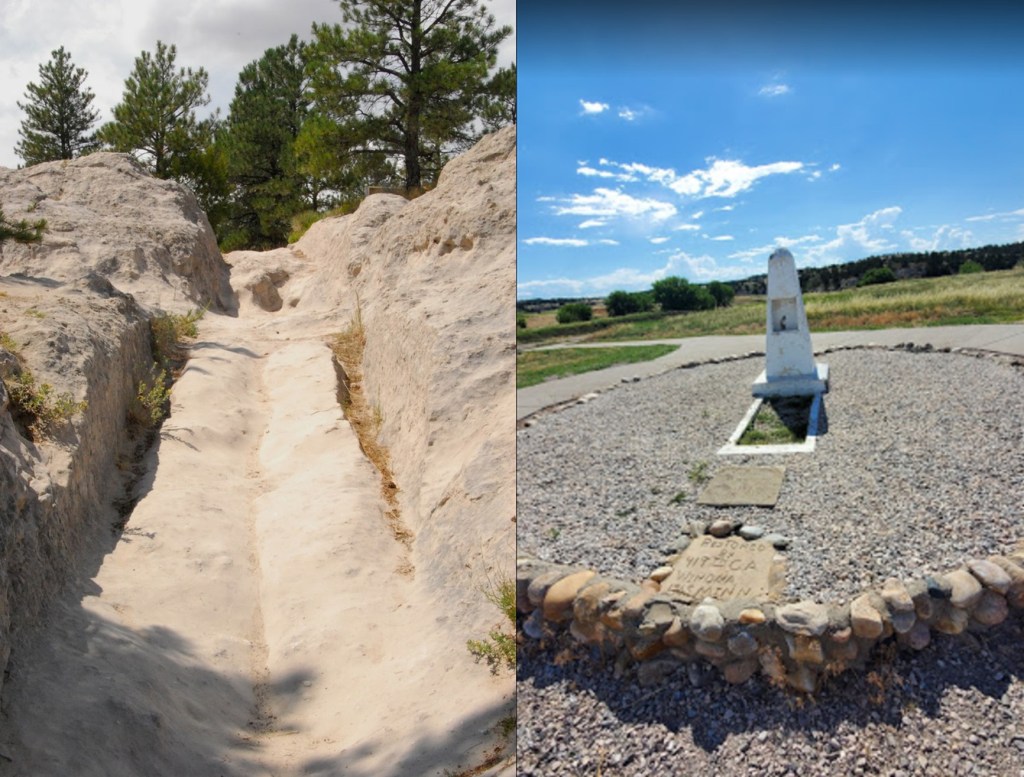
The Oregon Trail Ruts State Historic Site (https://wyoparks.wyo.gov/index.php/places-to-go/oregon-trail-ruts GPS coordinates -104.749, 42.257), also known as the Guernsey Ruts, are very well-preserved ruts carved by the passage of wagons over sandstone. This photo from Google Earth and downloaded from https://lh5.googleusercontent.com/p/AF1QipNGtvksq97jh38Vq9q952Td-6SDK7EoVkfu-gr7=w1440-h1440-pd shows a point where the road led up a sandstone outcrop and the wagon wheels cut down through the rock to produce the deep ruts. You can view a short Wyoming State Parks video about the ruts at https://www.youtube.com/watch?v=NkmNtJ_STHA&t=14s. You can also visit the gravesite of Lucindy Rollins (GPS coordinates -104.752, 42.261) near the entrance road to the ruts. The May 11, 1934 newspaper of Steamboat Springs, CO (https://www.coloradohistoricnewspapers.org/?a=d&d=STP19340511.2.70&e=——-en-20–1–img-txIN%7ctxCO%7ctxTA——–0——) carried the story of the grave. While the marker lists Lucindy Rollins, 1849-1934, it is believed that Lucindy died on the Trail in 1849 and her grave marker was re-discovered in 1934.
It was on July 21, 1842 that explorer John C. Fremont (https://archive.org/details/expeditionsofjoh01fr/page/230/mode/2up) camped near here. He wrote, “The road led over an interesting plateau between the north fork of the Platte on the right and Laramie river on the left. At the distance of ten miles from the fort we entered the sandy bed of a creek, a kind of defile, shaded by precipitous rocks, down which we wound our way for several hundred yards to a place where, on the left bank, a very large spring gushes with considerable noise and force out of the limestone rock. It is called “the Warm Spring,” and furnishes to the hitherto dry bed of the creek a considerable rivulet. On the opposite side, a little below the spring, is a lofty limestone escarpment, partially shaded by a grove of large trees, whose green foliage, in contrast with the whiteness of the rock, renders this a picturesque locality. The rock is fossiliferous, and, so far as I was able to determine the character of the fossils, belongs to the carboniferous limestone of the Missouri river, and is probably the western limit of that formation.”
June 18 – A 5-month virtual road trip along the California Trail
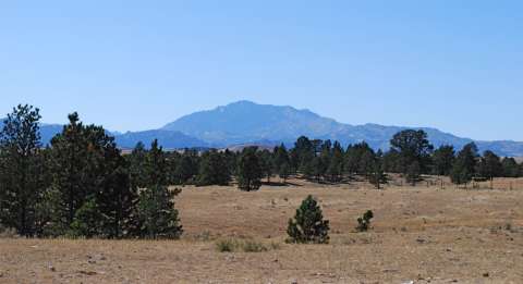
While not directly on the Trail, Laramie Peak was a significant landmark along the way. In the town of Guernsey, along the path next to the Guernsey visitor center (GPS coordinates -104.741, 42.269), a number of interpretive signs describe the various interesting historical sites and landmarks in the area, including Laramie Peak. Laramie Peak was mentioned frequently in emigrant diaries as it was a prominent mountain visible early on from the plains of western Nebraska and eastern Wyoming. The photograph is from https://www.wyohistory.org/encyclopedia/laramie-peak-landmark-oregon-trail.
In his book Roughing It (https://www.gutenberg.org/files/3177/3177-h/3177-h.htm), Mark Twain (Samuel Clemens) described his 1861 stagecoach journey across the Overland Trail from St. Joseph to Virginia City, Nevada. He said, “We passed Fort Laramie in the night, and on the seventh morning out we found ourselves in the Black Hills, with Laramie Peak at our elbow (apparently) looming vast and solitary—a deep, dark, rich indigo blue in hue, so portentously did the old colossus frown under his beetling brows of storm-cloud. He was thirty or forty miles away, in reality, but he only seemed removed a little beyond the low ridge at our right.”
June 19 – A 5-month virtual road trip along the California Trail
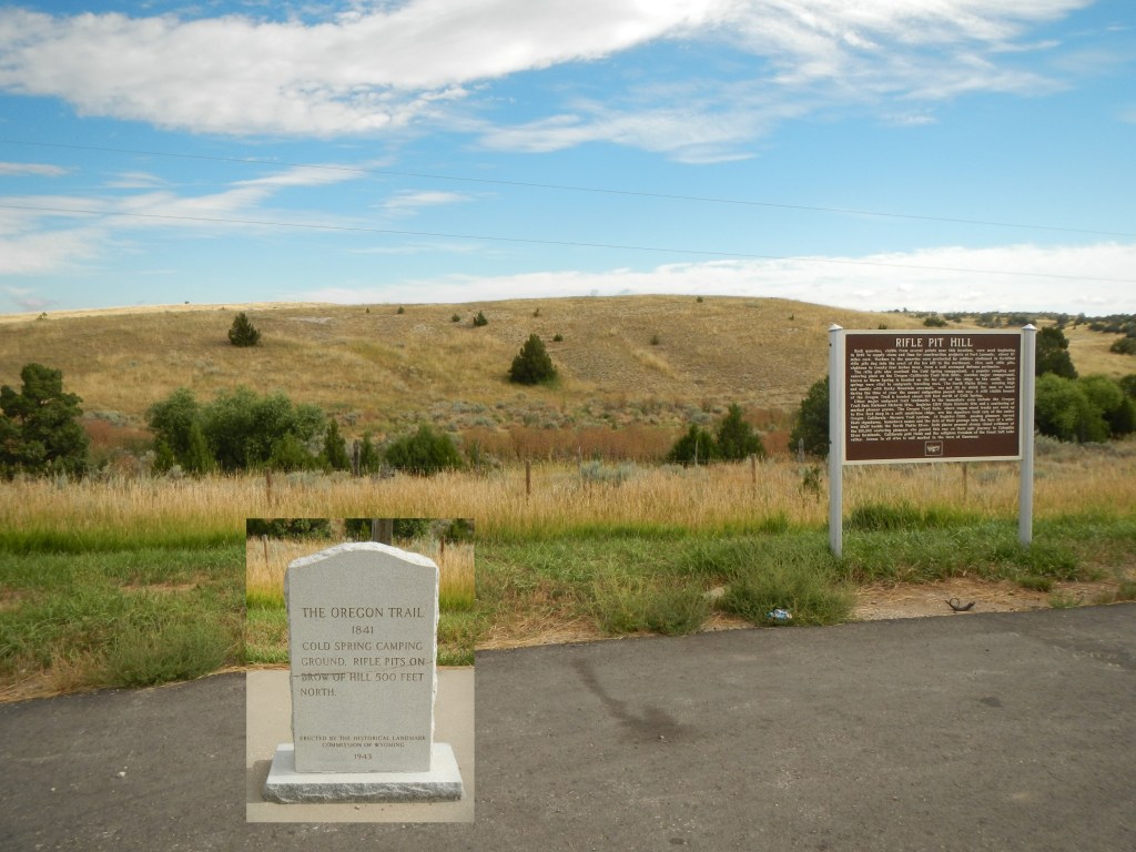
A popular camping spot called Cold Springs Campground is located close to highway 26 about 2 miles west of Guernsey, WY (GPS coordinates -104.790, 42.267). Also visible from this point (but on private land) is a hill from which stone was quarried for Fort Laramie and where soldiers dug defensive pits to maintain oversight and protection of the trail, quarries and campground. The photographs were downloaded from the Historical Marker Database at https://www.hmdb.org/m.asp?m=85753.
John Hawkins Clark (https://babel.hathitrust.org/cgi/pt?id=uc1.31822035077213&view=1up&seq=33&skin=2021) wrote about commencing this part of the journey on June 15 and 16, 1852: “June 15 – The Black Hills were to be encountered to-day. Having heard a good deal about the travel through this country we were anxious to realize the difficulties to be met with. We are to follow the Platte river 150 miles over this rugged, hilly country. The river cannot be followed only on its general course; it is now quite a narrow stream, rapid and very crooked. For days we see nothing of it, then again we are upon its banks where it goes rushing, foaming and thundering over great rocks or between high and nearly perpendicular walls of stone, almost a terror to contemplate. This region is very interesting; we pass many curious shaped mounds and ruin-like looking places that would in the states attract a great deal of attention. June 16 – Left one of the most beautiful camp grounds we have as yet occupied. The trail lay down a beautiful valley and opened out on the banks of the Platte river; nothing more wild in all of nature’s wild scenes that we have as yet visited can exceed this spot—a rushing torrent, foaming, whirling, leaping over great boulders, jarring the earth upon which we stand and making such a noise as would make thunder itself ashamed of its puny efforts.”
June 20 – A 5-month virtual road trip along the California Trail
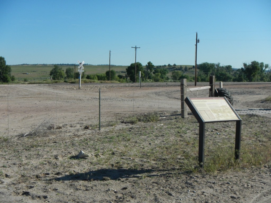
Another campsite mentioned in emigrant diaries is Bitter Cottonwood Creek (GPS coordinates -104.889, 42.314). There is an interpretive sign at the site and an old Oregon Trail stone marker. The photograph was downloaded from the Historical Marker Database at https://www.hmdb.org/m.asp?m=147855.
Emigrants who were keeping journals often times were doing so with the intent of passing the information on to other travelers as a sort of guide to the journey. Lorenzo Sawyer’s (https://www.octa-journals.org/merrill-mattes-collection/lorenzo-sawyer-st-joseph-to-california-in-1850) journal entry for June 5, 1850 is a good example: “About six miles from camp, we crossed a creek, and about one mile further another; about eight miles further we crossed Sage creek. This is on the river road. Some two miles from the last creek, the river and table roads come together again, and strike the river near a high rock to the left of the road. At this point, all had our first view of Fremont’s Peak far to the north-west. Another creek is found two miles further on. Then three miles, we come to Bitter Cottonwood creek, on the banks of which stand some ten or twelve trees, the first we have seen for many miles. Six miles further on, the road arrives at the river again. At this point, we took the old road on the south side of the river, instead of fording. We traveled four miles from the ford over very deep sand, and camped on the plains near the mountains, where we found tolerable grass. The road today has been mostly over a sandy country with heavy roads. We took on water at the ford. There has been but little grass today. Distance 32 miles.”
June 21 – A 5-month virtual road trip along the California Trail
The town of Glenrock, WY has several trail related sites which are described on their website at https://glenrock.org/index.asp?SEC=956877F2-3CFE-4DF3-8767-29E7FB222622&Type=B_BASIC. Oregon Trail Park, shown in the left photo was downloaded from Google Maps Streetview (GPS coordinates -105.853, 42.862). The park has original ruts and vegetation left undisturbed as part of the original construction of the park. Glenrock is also the location of the point where the Trail crosses Deer Creek. Glenrock Town Park (GPS coordinates -105.866, 42.863) is located about 2/3 of a mile west of the Oregon Trail Park and has an interpretive sign about the crossing alongside Deer Creek. The photo on the right of Deer Creek was also downloaded from Google Maps Streetview.
Elisha B. Lewis (https://www.octa-journals.org/merrill-mattes-collection/diary-of-overland-trip-to-california-elisha-b-lewis-1849), on June 26, 1849 wrote, “Left camp at 6 oclock drove 3 1/2 miles and camped on deer creek about 40 rods from whare it empted into the Platte we was beautifuly situated in a grove with a good spring of water near by our company had been detained on account of shoeing their oxen so that we staid in camp expecting when the Co came that they would conclude to cross the Platte They arrived to our place and camped in the afternoon arangements were made to ferry the next day by paying 14/ per wagon Grass was very poor for several Miles around There is an extencive bed of Stone coal 1/2 mile abouve our camp.”

