September 22 – A 5-month virtual road trip along the California Trail
Since September 15 we’ve been “virtually” exploring routes leading to California in the region around the Truckee River. Now we return to the other major river route – the Carson River. As weary travelers crossed the 40-mile desert toward the Carson River, they encountered Ragtown situated on the banks of the river. Not really a town, it got its name from the freshly washed clothing found all over the bushes along the banks of the river where emigrants took advantage of the river waters. Trading posts and small tents filled with wares soon cropped up to tap the funds of desperate travelers as well. A historical marker is located near Fallon, NV (GPS coordinates -118.919229, 39.505685) and his described at the Historical Marker Database (https://www.hmdb.org/m.asp?m=180202) where the accompanying photo comes from.
It was here (before Ragtown became a place) that Palmer C. Tiffany (https://collections.library.yale.edu/catalog/16699287) wrote, on August 7, 1849, “… at one o’clock A.M., our teams halted on the bank of Carson River, our of which we not only quenched our burning thirst, but gave our cattle an opportunity to slake theirs to the extent of their desires. Three of our cattle, having given out, were left to perish on the desert. Having unyoked & unsaddled we turned our animals loose to graze. We spread our blankets on the ground and layed ourselves down to sleep and rest till morning. We now hope our greatest difficulties are past having been dreading this stretch for a long time. The route over this stretch presents a very great scene of destruction. We counted 66 head of oxen and mules on this 45 mile stretch. Having passed in the night it is quite probable we did not see all that might have been seen by daylight. We passed some 40 or 50 waggons that were abandoned with large proportions of their loading. As the few animals left were not able to carry much, thousands upon thousands of dollars worth of property lies scattered over this heart-sickening desert.”

September 23 – A 5-month virtual road trip along the California Trail
Fort Churchill (http://parks.nv.gov/parks/fort-churchill# GPS coordinates -119.268, 39.294) was established in 1860 to protect the emigrant route, the Pony Express, and the new telegraph lines. This Nevada State Park preserves some of the ruins of the fort and provides visitor access and interpretation of the site. The accompanying photo comes from that website.
George Edwin Bushnell (http://freepages.rootsweb.com/~steelquist/genealogy/GeoBushnell.html) described stopping at Fort Churchill on September 9, 1864: “We are now encamped on the farm of T. Terford Esq. 9 mi. below Dayton. Our jog today is almost without Interest. 3 mi. drive brought us to the crossing of Carson River, near which is situated the neat little garrison Fort Church-hill. Near the Fort, we had the privilege of looking at some specimans of the game tribe, in the shape of dromadaries. I paused at the Fort with some friends, and accepted from them an invitation to dine after having witnessed a grand review of the troops. The train continued traveling up Carson River. We had a heavy wind during the entire day and the dust has been almost intolerable. There are a number of settlements along the river but little feed. Traveled 20 mi.”

September 24 – A 5-month virtual road trip along the California Trail
“Johnson’s Cutoff, also called the Carson Ridge Emigrant Road, passed over Spooner Summit and down Clear Creek from 1852 through 1854, but was rugged and little used.” This is the opening statement on the interpretive historical marker (GPS coordinates -119.896, 39.104) located on Spooner Summit on Highway 50 just east of Lake Tahoe. The cutoff provided an alternate route to the Carson River route through this region. The photograph and a description of the marker can be found on the Historical Marker Database at https://www.hmdb.org/m.asp?m=69714. The California-Nevada Chapter of OCTA has an informational webpage on this cutoff as well at http://canvocta.org/emigrant-trails-of-nevada-and-california/johnsons-cutoff/.
John McTurk Gibson (https://wjh.us/journal/sep5.htm) described this route on September 5, 1859: “What a road we passed over for three miles this morning, over and between rocks from the size of a sheep to that of a church and yet over such roads what an amount of freighting is done, with stout teams and strong wagons. We sometimes see as many as eight or nine spans of horses or mules hitched to one wagon, and then something has to come or break. The balance of the day’s drive was mostly a down-hill grade about 1½ feet to the rod, a very good road for mountain travel, days drive 18 miles or so.”

September 25 – A 5-month virtual road trip along the California Trail
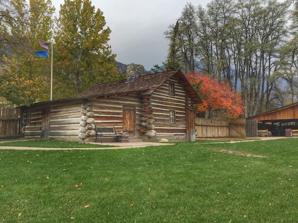
Continuing along the Carson Trail we encounter the Mormon Station State Historic Park (http://parks.nv.gov/parks/mormon-station GPS coordinates -119.845, 39.004) in the community of Genoa, NV. The site is where Nevada’s first non-native settlement was established, in 1850, to serve as a trading post along the Carson Trail. You can visit a museum and recreation of the trading post there today. The accompanying photograph came from their website.
Franklin Langworthy (https://archive.org/details/sceneryofplainsm00languoft/page/154/mode/2up) stopped at the Mormon Station on October 10, 1850. He wrote, “At noon, we stopped at a trading-post, called the Mormon Station. It is a large log building, standing in the skirts of the pine grove which covers the mountain side, and at this point extends quite down to the level of the valley. These are the nut-bearing pines, full of pitch, tall, and covered with limbs to within eight or ten feet of the ground. Some of these trees were six feet in diameter. We encamped where wood, water and grass were abundant, and here found several companies of emigrants.”
September 26 – A 5-month virtual road trip along the California Trail
Now the site of a modern resort, Walley’s Spring (https://travelnevada.com/hotels/unique-stays/david-walleys-resort/ GPS coordinates -119.833, 38.981) has long been a site of relaxation and the waters were mentioned numerous times in emigrant diaries. The Travel Nevada website listed here provides a bit of background and history and also the accompanying photograph.
William Riley Franklin (https://archive.org/details/annalsofwyom46121974wyom/page/68/mode/2up) described this valley on July 10, 1850: “We advanced 10 miles and rested, thence 10 miles farther brought us to our encampment on a beautiful mountain rivulet of clear transparent running water. Here we found excellent grass, hence our mules set this night apart for eating, while they enjoyed the unenviable privilege. This day’s march traversed the western extremity of a beautiful and delightful valley. Near the foot or eastern side of a chain of mountains, towering high in the heavens, covered with pine timber. The Mormons are establishing themselves in this valley and creating a fort. This valley will no doubt produce fine corn, wheat etc., by irrigation, which can be done very easily. I and another gentleman took a hunting excursion in the pine forest near the foot of the mountains and enjoyed the scenery finely. During this ramble we saw some sublime and lovely sights. O! with what greediness and insatiable thirst for such scenery. I looked upon this forest, roaring rivulets and towering mountains until my eyes were wearied from continually gazing at the objects before us. Many and many an hour have I gazed (unconscious of all around me) upon the beautiful and rugged face of nature clothed in living verderers. If I had one of those lovely mountains, pine forest, and beautiful valleys and ever-roaring mountain springs situated in the United States where I desire, all the wealth of earth could not purchase it.”

September 27 – A 5-month virtual road trip along the California Trail
After leaving the lower Carson River valley the road turned west into a narrow canyon for about 5 miles before turning south again into Hope Valley (GPS coordinates -119.945, 38.743). The canyon road was pretty rugged and Hope valley provided another respite before the more arduous task of crossing the summit of the Sierra Nevadas. The name of Hope Valley apparently originated from the “hope” experienced by the original road-blazers of the Mormon Battalion who established the road west to east in 1848. The photograph is from https://upload.wikimedia.org/wikipedia/commons/0/0e/Hope_Valley_in_Alpine_County.jpg.
Henry W. Starr (https://www.octa-journals.org/merrill-mattes-collection/diary-of-henry-w-starr-1850) described the canyon approaching Hope Valley on September 6, 1850: “Here we began to see signs of the Elephant and soon the various parts of the animal presented its self to view in the shape of huge piles of stones over which we had to pass and why any men ever immagined that a Waggon could pass up here is a mystery to me but they had passed over them and acting upon the Principle that what man had done man could do. We undertook to fight our way through and such rolling and tumbling of oxen and waggon I never saw the wheles would strike stone frequently that were two thirds as high as the fore wheel and then chuck down on to another Stone with such force as I would have thought enough to stave a common Road Waggon all to pieces but our little Waggon still bears up under it…. (9/7) We made a tolerable early start this morning after passing out of the valley we had some rough road for 1/3 of a mile when we come into another valley where we found excelent roads and the Road continued pretty passable to Red lake 17 miles from where where we started from in the morning.”

September 28 – A 5-month virtual road trip along the California Trail
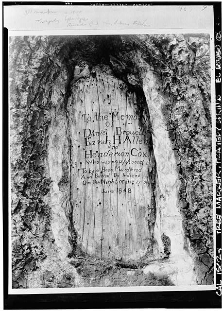
The Mormon Battalion had been in California to fight in the Mexican – American War and were returning to Salt Lake City. They were asked to find a better route across the mountains for the influx of emigrants and blazed the Carson Route in 1848. On June 27 three of their scouts were attacked and murdered by unknown people. When they were found, their bodies were buried in a common grave and their names were carved on a nearby tree. The photograph is from the Library of Congress at https://www.loc.gov/pictures/item/ca0161.photos.020555p/resource/ and a description can be found on the Historical Marker Database at https://www.hmdb.org/m.asp?m=21273 (GPS coordinates -120.147, 38.639).
In 1850 Margaret Frink (https://babel.hathitrust.org/cgi/pt?id=njp.32101079825640&view=1up&seq=124&skin=2021) related a different story that she had apparently heard: “The men on guard with the horses had a frosty night of it, and came in early to breakfast. Some wild onions, or “leeks,” had been found, which, at dinner, we enjoyed very much. These were the first vegetables we had tasted since receiving the lettuce and onions from Captain Grant at Fort Hall, seven weeks before. This was another hard day. We had expected an easier road down the mountains after crossing the main ridge, but were disappointed. Our road to-day was very rough, up and down mountains all the way. To make matters worse, our white horse gave out to-day, he having fallen and hurt himself while we were coming up the one-mile mountain. He was a favorite horse, and we gave fifty cents a pound for flour to mix in water for him to drink, thinking it would strengthen him; but we only managed to get him as far as Tragedy Springs, where we had to leave him for the night. It was two miles further before we could find a camping-place, and the next morning, when Mr. Frink sent Russell back for him, he found the faithful animal dead. These springs were named from a tragical affair occurring in 1849, in which two men, intoxicated, got into a fight with each other, in which one of them was killed.”
September 29 – A 5-month virtual road trip along the California Trail
Before we reach our journey’s final destination we’ll mention one more route to California. The Historical Marker Database (https://www.hmdb.org/m.asp?m=7566) provided the photograph and description of a marker in Sonora that commemorates the ending point for the Sonora Trail (GPS coordinates -120.369, 37.975). The trail along the Walker River and over Sonora pass was only used for a few years in the early 1800s. Trails West has a driving guide available for purchase at https://emigranttrailswest.org/trail-guides-for-purchase/walker-river-sonora-trail-driving-guide/.
The Bidwell-Bartleson party passed through this region, but not exactly where this road went. On October 21, 1841 John Bidwell (https://www.loc.gov/item/10005282/) wrote, “We ascended the mountain on the north side of Walker River to the summit, and then struck a stream running west which proved to be the extreme source of the Stanislaus River. We followed it down for several days and finally came to where a branch ran into it, each forming a cañon. The main river flowed in a precipitous gorge, in places apparently a mile deep, and the gorge that came into it was but little less formidable. At night we found ourselves on the extreme point of the promontory between the two, very tired, and with neither grass nor water. We had to stay there that night. Early the next morning two men went down to see if it would be possible to get down through the smaller cañon. I was one of them, Jimmy Johns was the other. Benjamin Kelsey, who had shown himself expert in finding the way, was now, without any election, still recognized as leader, as he had been during the absence of Bartleson. A party also went back to see how far we should have to go around before we could pass over the tributary cañon. The understanding was that when we went down the cañon if it was practicable to get through we were to fire a gun so that all could follow; but if not, we were not to fire, even if we saw game. When Jimmy and I got down about three-quarters of a mile I came to the conclusion that it was impossible to get through and said to him, “Jimmy, we might as well go back; we can’t go here.” “Yes, we can,” said he, and insisting that we could, he pulled out a pistol and fired.”

September 30 – A 5-month virtual road trip along the California Trail
Here we conclude our virtual journey along the California Trail by visiting Sutter’s Fort (GPS coordinates -121.471, 38.572). The site is a State Historic Park (https://www.parks.ca.gov/?page_id=485) and the photograph comes from the Historical Marker Database at https://www.hmdb.org/m.asp?m=11886. John Sutter immigrated from Switzerland and received a land grant from Mexico in what is now the Sacramento area in 1839. He built Sutter’s Fort as a supply depot for the pioneers coming to California. However, the discovery of gold at his mill site ultimately led to his property being overrun and forcing his bankruptcy.
John Sutter (https://www.loc.gov/item/34013250/) wrote in April, 1838, “In Monterey I arranged my affairs with the Custom House, and presented myself to Govr. Alvarado, and told him my intention to Settle here in this Country, and that I have brought with me 5 White Men and 8 Kanacas (two of them married). 3 of the Whitemen were Mechanics, he was very glad to hear that, and particularly when I told him, that I intend to Settle in the interior on the banks of the river Sacramento, because the Indians then at this time would not allow white Men and particularly of the Spanish Origin to come near them, and was very hostile, and stole the horses from the inhabitants, near San Jose. I got a General passport for my small Colony and permission to select a Territory where ever I would find it convenient, and to come in one Years time again in Monterey to get my Citizenship and the title of the Land, which I have done so, and not only this, I received a high civil Office (“Representante del Govierno en las fronteras del Norte, y Encargado de la Justicia”).”

