August 22 – A 5-month virtual road trip along the California Trail
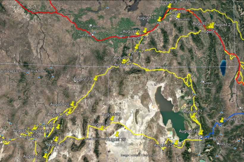
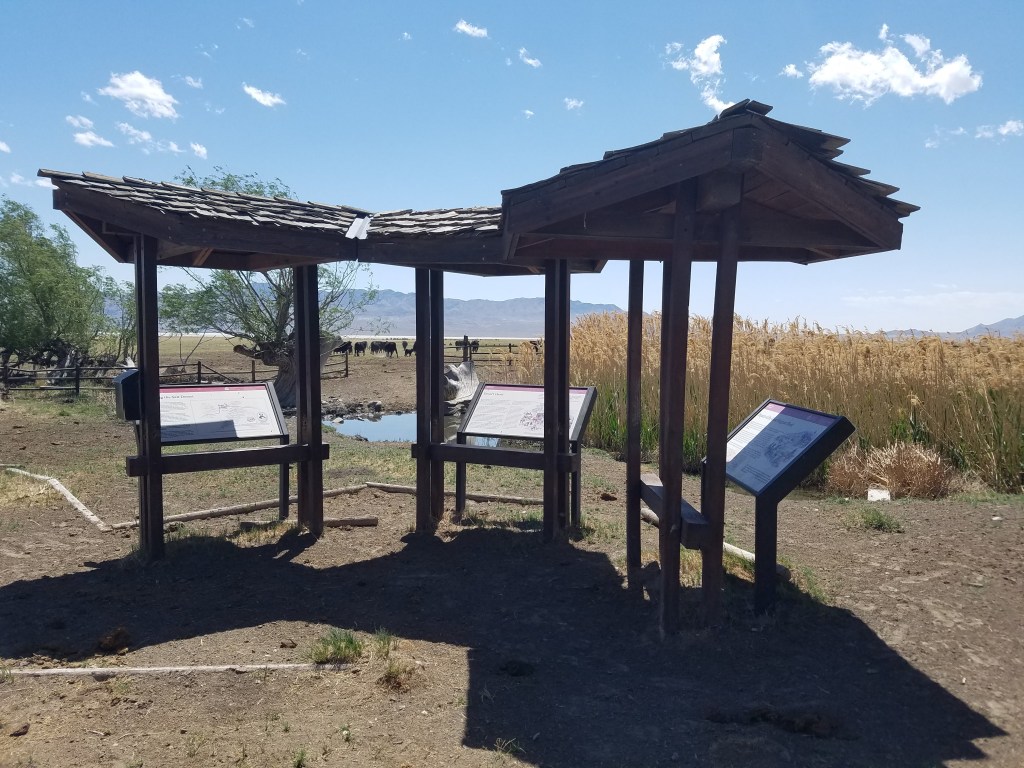
Lying within the boundaries of Elko, Nevada, the Hot Hole (GPS coordinates -115.778, 40.818) and associated springs were mentioned quite frequently in emigrant diaries. You can view the recently installed interpretive exhibit on the California Trail Center app and mirror website at https://ctic.oncell.com/en/hot-hole-322443.html. The photograph accompanying this post is by Trail Center staff.
Amos Steck (https://www.octa-journals.org/?s=amos+steck) wrote about the Hot Hole on August 20, 1849: “About five miles from our last night’s camp we reached the ‘Hot Springs’. They are situate on the left side of the River as we descend it. On its immediate bank there are perhaps a dozen of these, six in the immediate vicinity large quantities of Saline effervescence that has comingled with sulphur (as I think from the smell & appearance) to the depth of several feet has been thrown off from the [?]. Some of the springs as they gush from the hillside send up a vapor which from its heat as I stood over the spring was difficult to respire, the temperature was certainly near if not quite at the boiling point. I consider these the greatest curiosity which I have yet seen. We were told by some emigrants who were at the springs that there was a large lake immediately over the Bluffs the waters of which were equally as hot – but as my companions & messmates had no curiosity to see it I felt loath to go alone & get behind my train. These springs probably run directly from this lake if the report be as it is stated.”
August 23 – A 5-month virtual road trip along the California Trail
The California Trail Interpretive Center (the host for these Facebook posts) is open year-round and is located 8 miles west of Elko, Nevada along I-80 (exit 292 GPS Coordinates -115.932, 40.763). Opened in 2012, the Center was placed at the historically significant point where the Hastings Cutoff (which we’ll begin discussing in tomorrow’s post) rejoins the main California Trail. The Center has two main informational websites: http://www.californiatrailcenter.org/ which is managed by the partner non-profit organization Southern Nevada Conservancy and the mirror website for the Center’s free mobile app (available on the Google and Apple app stores) at https://ctic.oncell.com/en/index.html. Both of these sites provide information about your visit to the Center and associated Trail information as well. The Trail Center is managed by the Bureau of Land Management. The photograph is by Trail Center staff.
Israel Shipman Pelton Lord (https://www.octa-journals.org/merrill-mattes-collection/journal-of-isaac-s-p-lord), a physician traveling the Trail in 1849 was very descriptive in his writing. Speaking of the Elko Valley near the Trail Center he wrote, on August 30, “From a long distance above it may be seen that the valley is shut in at its southwestern extremity by the junction of the two ranges of mountains. Toward the lower end of the valley, at the left hand, may be noticed a pyramidal mountain peak which from the distance of a few miles presents the appearance of an Indian Pagoda. The whole upper portion seems formed of thick layers of earth, alternating with thin plates of stone, at very regular intervals. The layers of rock project considerably beyond the slope, with rather sharp jagged edges, the whole gradually and regularly diminishing to a point and dotted with dwarf cedars. As you pass round to the west, the point appears to stretch off into a ridge. Beyond this, as seen from a long distance up the valley, and a little to the right, is a similarly shaped peak, but lower, smooth, and without vegetation except grass. It slopes toward the north, and rises again gradually into a ridge. At this depression the mountain side seems bare and rocky, except a few patches of cedar, with a notch cut down right and left at an angle of 45 degrees, and this is a kanyon through which the road passes.”

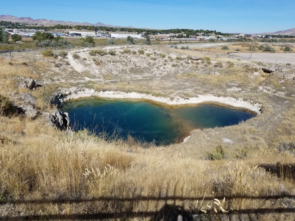
August 24 – A 5-month virtual road trip along the California Trail
On August 16 we visited Salt Lake City (virtually) and took the Hensley Cutoff north to City of Rocks. The other route from the Salt Lake Valley was called the Hastings Cutoff, proposed by Lansford Hastings in his book The Emigrants’ Guide to Oregon and California (https://babel.hathitrust.org/cgi/pt?id=mdp.39015039364503&view=1up&seq=11&skin=2021). For a route description of the Hastings cutoff, I highly recommend https://scienceviews.com/historical/hastingstext.html for a driving tour. One historical stop that is worth visiting is the Benson Mill (http://bensonmill.org/) in Tooele, UT (GPS coordinates -112.297, 40.651). The accompanying photograph comes from their website.
Sarah Davis (https://collections.library.yale.edu/catalog/10001144) remarked about the building of the mill on August 23, 1850: “we traveled fifteen miles and past plenty of salt the lake is as salt as brine let it be made as strong as it can be the road is good here and plenty of good water we then come to a nother mormen setelment whare they was building a mill a saw mill we then went about a mile to the good springs called bentons mill springs one was salt and the other not we then camped being very tired.”
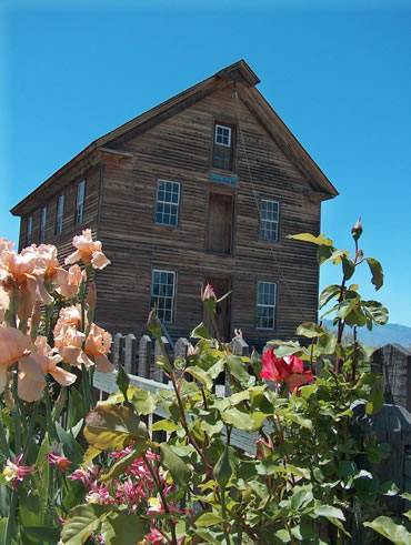
August 25 – A 5-month virtual road trip along the California Trail
Driving Interstate 80 across the salt flats west of the Great Salt Lake is much easier than the trek the emigrants following the Hastings Cutoff had to make. Stop at the rest area (GPS coordinates -113.852, 40.740) near the western end of the flats to get a good view, walk or drive onto the flats. The state of Utah has an information page about the Salt Flats at https://www.utah.com/destinations/natural-areas/bonneville-salt-flats/#readmore. The accompanying photograph is by Trail Center staff.
13-year old Virginia Reed (Covered Wagon Women Volume 1 preview available at https://www.google.com/books/edition/Covered_Wagon_Women/9i9ajDTZ9XAC?hl=en&gbpv=1), writing in a letter to her cousin Mary Keyes after the conclusion of their tragic journey in the Donner/Reed party said, “we come to Brigers Fort & lost another ox we sold some of our provisions & baut a yoak of Cows & oxen & they persuaded us to take Hastings cut of over the salt plain thay said it saved 3 Hondred miles, we went that road & a nother day and at noon pa went on to see if he could find Water, he had not bin gone long till some of the oxen give out and we had to leve the Wagons and take the oxen on to water one of the men staid with us and others went on with the cattel to water pa was a coming back to us with Water and met the men & thay was about 10 miles from water pa said thay git to water that night, and the next day to bring the cattel back for the wagons and bring some Water pa got to us about noon.”
August 26 – A 5-month virtual road trip along the California Trail
If you leave I-80 just east of Wendover and take the Leppy Pass Road north it will lead you eventually to Pilot Peak and Donner Spring. Donner Spring is on private property but the ranch has provided visitor access to the spring (GPS coordinates -113.969, 41.021). Snowmelt and rainfall from the Pilot Peak range flows under ground and emerges in a series of springs along the boundary between the mountain foothills and the salt flats. These springs provided life-saving water to those travelers who had braved the 90-mile desert to reach them. There are interpretive signs alongside Donner Spring. The accompanying photograph is by Trail Center staff.
John Wood (https://archive.org/details/GR_4732/page/n3/mode/2up) described arriving at the Spring on August 6, 1850: “When we got within ten miles of the water, our cattle seemed to know, by some instinct, that water was not far-ahead, and become animated with new life and the two small yoke we had attached to our big wagon, walked as fast as I could and sometimes would trot, and when we got within a mile of the water, I had to walk before them to keep them from running. Who could not sympathize with flesh and blood, suffering in this way. It was 1 o’clock at night when we got through. This was the severest trial I have had by far, the desert proving to be ninety-three miles instead of seventy-five, as we had understood, and having to walk all the way, almost without stopping, with but little to eat and drink, and no sleep, was soul-trying, in the extreme. We dropped our bodies under the wagons and in less than five minutes were in a state of unconsciousness. Thus far the Lord hath brought ns on.”
August 27 – A 5-month virtual road trip along the California Trail
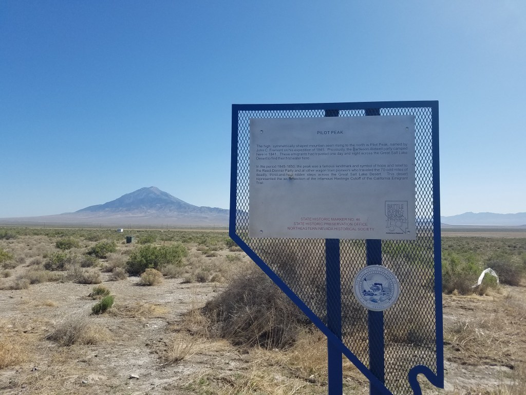
Proceeding west on I-80 from Wendover, UT you’ll see Pilot Peak on your right. This mountain was named by explorer John C. Fremont to acknowledge its usefulness as a guidepoint across the salt desert to the location of water. There is a Nevada Historical Marker and a set of interpretive signs located at exit 398 (GPS coordinates -114.208, 40.845) in a pullout viewpoint of the peak. The photograph is by Trail Center staff.
It was in the plain just before you that Edwin Bryant (https://archive.org/details/whatisawincalifoin00brya) noted the following on August 5, 1846: “After travelling about ten miles we struck a wagon-trail, which evidently had been made several years. From the indentations of the wheels, where the earth was soft, five or six wagons had passed here. The appearance of this trail in this desolate region was at first inexplicable; but I soon recollected that some five or six years ago an emigrating expedition to California was fitted out by Colonel Bartlettson, Mr. J. Chiles, and others, of Missouri, who, under the guidance of Captain Walker, attempted to enter California by passing round the southern terminus of the Sierra Nevada; and that they were finally compelled to abandon their wagons and every thing they had, and did not reach their destination until they had suffered incredible hardships and privations. This, it appeared to me, was evidently their trail; and old as it was, and scarcely perceivable, it was nevertheless some gratification to us that civilized human beings had passed here before, and left their mark upon the barren earth behind them. My conjectures, above stated, have been subsequently confirmed by a conversation with Mr. Chiles.”
August 28 – A 5-month virtual road trip along the California Trail
Travelers on the Hastings Cutoff were fairly impressed by what today is known as Ruby Valley on the east side of the Ruby Mountains (GPS coordinates -115.268, 40.626). They often remarked about the abundance of water and lush grasses of the valley. But they also often had misconceptions about the mountains next to them. Often having snow on their peaks even in July, some emigrants thought they had reached the base of the Sierra Nevadas, not understanding that those mountains were still hundreds of miles away. Ruby Valley today is home to the Ruby Lake National Wildlife Refuge (https://www.fws.gov/refuge/ruby-lake). The photograph is by Trail Center staff.
A good representation of emigrant thoughts while in Ruby Valley are those of Chauncey B. Hubbard (https://www.octa-journals.org/merrill-mattes-collection/diary-chauncey-b-hubbard-1850) from 1850: “August 5th – Drove 16 miles and camped near some snowy mountains, which we suppose to be the Sierra Nevadas, we began to feel as though there was some prospect of getting through sometime this season now. We shall be a jolly crew when we do safely land on those golden shores and nothing to do but search for the evil root, but Oh! what a day of jubilee we shall have when we get back to our friends and homes with money enough to make us comfortable (if so be we are so fortunate). August 6th – Drove 25 miles along the foot of the snowy mountains, and the edge of a most beautiful valley where there has been thousands of acres of splendid grass and numerous little streams coming down the mountains and running into it making a most delightful place of it, red clover and red top is quite abundant here also. If timber was plentiful this would be paradise not to be equaled this side of Missouri.”

August 29 – A 5-month virtual road trip along the California Trail
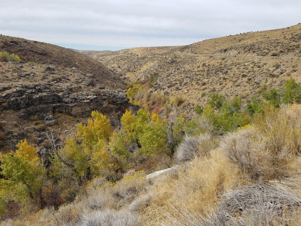
Secret Pass (GPS coordinates -115.229, 40.849) was not used by wagons to cross the Ruby Mountains because the stream canyon was too narrow and rocky. It is a prominent pass lying between the north and of the Rubies and the south end of the East Humboldt Range. It was used, though, by explorers and emigrants traveling with packs and mules. A paved road, Highway 229, exists today over this lovely pass accessed from the Halleck Exit #321 off I-80. This is also near the site of historic Fort Halleck (https://www.gbcnv.edu/howh/FtHalleck.html), occupied from 1867 to 1886. The photograph of the pass is by Trail Center staff.
Edwin Bryant (https://archive.org/details/whatisawincalifoin00brya) described the pass in this way, on August 8, 1846, “Crossing this stream and the bottom opposite, we passed through a low gap of a range of hills, on the western side of which we struck another small stream of water, which flows through a fertile, grassy valley, in a northwestern course. After descending this valley some five or six miles, the stream canons between high and precipitous hills, along the sides and over the tops of which we were compelled to select our way to the best advantage, until we emerged into the spacious valley of Mary’s river, the sight of which gladdened our eyes about three o’clock, p. m.”
August 30 – A 5-month virtual road trip along the California Trail
Harrison Pass (GPS coordinates -115.511, 40.325) was used by the Bidwell/Bartleson party after they abandoned their wagons in Goshute valley in present-day eastern Nevada. Harrison Pass is accessed from Ruby Valley where a graded dirt road ascends the pass and then becomes paved at the descent of the western side. The photograph is by Trail Center staff.
Describing Ruby Valley and the pass, John Bidwell (https://www.loc.gov/item/10005282/) wrote in his 1841 journal, “September 21st – About 10 o’clock a. m., as we were coasting along the mountain in a westerly direction,, we came to some hot springs, which were to me a great curiosity. Within the circumference of a mile there were perhaps twenty springs, the most of which were extremely beautiful, the water being so transparent we could see the smallest thing twenty or thirty feet deep. The rocks which walled the springs, and the beautiful white sediment lodged among them, reflected the sun’s rays in such a manner as to exhibit the most splendid combinations of colors—blue, green, red, &c..—I have ever witnessed. The water in most of them was boiling hot. There was one, however, more beautiful than the rest; it really appeared more like the work of art than of nature. It was about four feet in diameter, round as a circle, and deeper than we could see—the cavity looked like a well cut in a solid rock, its walls being smooth and perpendicular. Just as I was viewing this curiosity, some hunters came up with some meat; we all partook, putting it into the spring, where it cooked perfectly done in ten minutes. This is no fish story! September 23rd – We could see no termination of the valley, nor any signs of Mary’s River. We therefore concluded that we were too far south, and passed over the mountains to the north, where we struck a small stream running towards the northwest. On this we camped and found plenty of grass; a few fish were caught, some of which were trout, which led us to the conclusion that this was a branch of Mary’s River.” They continued on and in a few more days finally reached the Humboldt River via the South Fork River Canyon (which we’ll visit virtually on September 1).

August 31 – A 5-month virtual road trip along the California Trail
Emigrants traveling along the Hastings Cutoff with wagons finally reached the southern end of the Ruby Mountains at Overland Pass (GPS coordinates -115.582, 40.018). This was a relatively low and easy pass across the mountains where they turned back north to travel back up Huntington valley. The route they had followed took them 50 miles south, then 15 miles west and then 50 miles north again just to get around/across the Rubies – quite a long detour! This pass was also utilized later by the Pony Express and the Overland Stage road and Fort Ruby (https://www.gbcnv.edu/hickson/FtRuby.html) lies near the point where the road Hastings road turns to cross the pass. The photograph of Overland Pass is from http://elkorose.schopine.com/overlandpass.html.
Costmor H. Clark (https://repository.arizona.edu/handle/10150/640818) crossed Overland Pass on August 6, 1850: “Continued our course along the base of the mountains for about 20 miles when we left the valley by turning to our right through a gap in the mountains travelling in a N. Westerly direction over a rough hilly country until 9 at night when we encamped in a valley upon a small stream running North. Crossed today several indian fences (if it is proper to call them so) they consist of sage bushes with the roots turned upwards and placed two or three feet apart and extending in a line over hill and valley as far as the prospect extends. What is the use of them is to me a mistery. Some suppose they mark the boundary of different tribes or families and some that they have something to do with the capture of game. It proves to me that we are in the vicinity of Indians and that Is no peculiar comfort to me seeing that I am minus my rifle. We are somewhat apprehensive of their stealing our horses if not our scalps—Made a fire of “greese weeds” cooked our supper and turned in.”

