May 22 – A 5-month virtual road trip along the California Trail
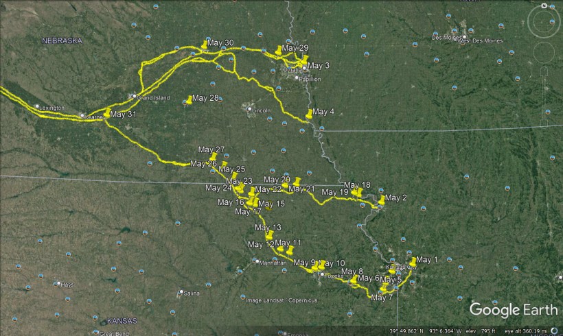
The Big Blue river crossing lies just west of Marysville, KS very near where US Highway 36 crosses it. Near here you can visit Historic Trails Park (GPS coordinates -96.659, 39.843) which has several interpretive signs and a full-size replica of a rope ferry that was used by emigrants to cross the river. The photographs were downloaded from https://www.visitmarysvilleks.org/attraction/historic-trails-park/ and from https://lh5.googleusercontent.com/p/AF1QipPSzxihRnCwm1iS1T7sLSpZQYlmKuPFkDrrcmdJ=h1440.
John Clark (https://www.octa-journals.org/merrill-mattes-collection/a-pretty-fair-view-of-the-eliphent-charles-g-hinman-1849) wrote on May 15, 1852, “All were up. Broke the cracker barrel to make fire & roasted the hawk for myself. The rest done without. Put forward on the road by sunrise. Past a man just buried from Perry’s train. He was not fairly covered. His old boots still on his feet pointed up through the sand. We had no spade to cover them so we had to pass on. Over a wide & level plain without water, but a few trees in the distance, to Big Blue, 15 miles. Here was over 100 waggons waiting their turn to ferry & ford. Some drove through but we, like many others, paid three dollars & took the boat. This is a mild running stream, 50 yards wide. Large cottonwood on the banks, grass on the flat. A little trading post on the bank that sells awful dear. Sugar, coffee & bread, 50 cents the pound. Whiskey six bits the pint, or 50 the drink.”
May 23 – A 5-month virtual road trip along the California Trail
The St. Joseph and Independence Roads join about nine miles west of the Big Blue River crossing (discussed in yesterday’s post), southeast of Hanover, KS (GPS coordinates -96.814, 39.877). The two photos of markers were downloaded from the OCTA Gateway Chapter website at https://www.gateway-octa.org/trail-gallery-1 and can be found somewhere along the roads that circuit the junction.
Vincent Geiger (https://archive.org/details/trailtocaliforni000849mbp/page/n99/mode/2up) camped just a little west of the Big Blue River on May 20, 1849. He said, “We got into camp 2 miles from the Big Blue about 4 o’clock P.M. and commenced lightening our loads. We threw away a large lot of horse shoes, all the boxes, lard & many other things. We are now fairly on the road. Many are complaining and if chance offered would like much to return. We have been vexed & delayed. Our teams are young & unbroke & the men do not feel as much interest as was to be expected. Our company is too large. The country is not so much rolling – more plain. We are about 1 mile from the Big Blue. May 21st – An early start gave us a good march today. Just as we drove out from camp, Comegys broke a fore-wheel to his wagon, but as we had saved one from the destruction of yesterday it delayed us but little. In nine miles from camp we struck the Independence Trail and fell in with a Missouri Company, of 40 wagons & 130 men. Passed them.”

May 24 – A 5-month virtual road trip along the California Trail
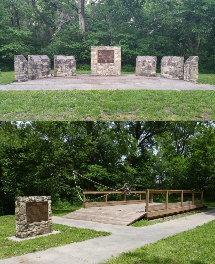
The Hollenberg Pony Express Station State Historic Site (GPS coordinates -96.847, 39.901) is a good place to visit on this virtual road trip (https://www.kshs.org/p/hollenberg-pony-express-station/19565). Emigrants would cross Cottonwood Creek about a quarter mile south of the station. It was a supply stop, stage stop, and Pony Express stop and has interpretation and museum displays relating to all of these. The photograph from Hollenberg Station is from Google Maps Streetview.
Dr. Charles M. Clark wrote a book called A trip to Pike’s Peak (https://archive.org/details/triptopikespeakn00clar/page/22/mode/2up), detailing his travels from Saint Joseph to the Colorado Gold Rush in 1860. He references both Cottonwood Creek and the Station: “After leaving the Big Blue River, the road leads over a country similar to that I have described in the preceding letters. The country is very well settled, especially along the borders of the river, and I judge it to be very productive; but this section of country seems to be especially subject to violent storms and tornadoes; no less than two or three swept through there the past season, destroying everything they came in contact with, unroofing houses and scattering their timbers far and wide, prostrating fences, killing stock and doing immense damage. At a distance of twelve miles we reach Cottonwood Creek, a small stream which is dry during the summer months. The approach to it is winding and steep, and as the bed of the stream contains several large stones at the ford, some care is necessary in driving. There are two good springs here, but no wood. The Stage Company have a station here, and there is also one or two other buildings. On leaving this stream, a series of long but gradually sloping hills have to be crossed, for a distance of five miles, when we arrive at a good camping ground, known as Seventeen Mile Point, where there is a well of water, besides a good spring and plenty of wood. The game seen on the plains is not as plenty as one would naturally expect; but very little is seen along the line of travel; now and then a small herd of antelope are seen grazing near the bluffs, or passing down to the river, but so shy it is almost impossible to get within rifle range of them, without resorting to a decoy. Anything red in color will attract their attention and draw them, and a person wearing a red shirt can hunt them more successfully than another, if he will take a position and remain quiet.”
May 25 – A 5-month virtual road trip along the California Trail
There is an Oregon Trail Marker located on the Kansas / Nebraska boundary at the intersection of State Line road and 582nd Ave (GPS coordinates -96.916, 40.002). The marker indicates the point at the state line where the Trail crosses. The photograph is from Google Maps Streetview. It was near here that Alonzo Delano (https://archive.org/details/lifeonplainsamon01dela/page/n7/mode/2up) reached the road in 1849. The company he was traveling with had opted to begin their journey about sixty-five miles north of St. Joseph (but south of Nebraska City) and “take an obscure route, over which only one train had passed, about four years previous, and strike the St. Joseph and Platte road at a point which it was said would put us in advance of the St. Joseph and Independence trains, at least ten days.” However, on May 20th he wrote, “Our road, like that of yesterday, was over broad table-land, and we were able to keep a direct south-south-west course. But where the dickens was the St. Joseph road? Where were we?—and where had we been? We had now been out nineteen days upon the wilderness. Our object in taking this new route had been to save time, and of getting in advance of other trains; and the question naturally arose, Had we succeeded? Had we gained anything by our erratic course?”
It was later that day that they found the road. Continuing in his journal Delano wrote, “We encamped on a fine bottom near a pretty creek, a mile from the road, and a camp of emigrants was reported below us, to which Henderson repaired, and learned that a large number of wagons were ahead, and that we were only an hundred and fifty miles from St. Joseph. From the latter place we had been actually traveling twenty-four days, nineteen of which were upon the prairie, to reach this point; while the trains that had come by the road, direct, had come through without difficulty in eleven days. This was gaining time and getting ahead with a vengeance!”

May 26 – A 5-month virtual road trip along the California Trail
Rock Creek Station State Historical Park (http://outdoornebraska.gov/rockcreekstation/ GPS coordinates -97.061, 40.113) was a stage stop established in 1857. It has trail ruts and buildings and displays about the Pony Express and emigrant trails. The photograph is from Google Maps Streetview.
The 1864 journal of George Forman was published in the 1968 Annals of Wyoming (https://archive.org/details/annalsofwyom40121968wyom/page/n9/mode/2up). On June 10th he wrote, “… now in Nebraska…. left the freight [train] and travel alone, meeting the overland Stage everyday and every 14 miles is a Stage Station, but no letters. Crossed Rock Creek. Plenty of Prairie fowl, prairie hens, Pigeons &c. In Kansas the rock is limestone and soil heavy. In Nebraska here it is granite rock and light gravelly soil though rich. Timber all the way is very scarce, only cottonwood & walnut along the Streams. Some spaces of 20 miles without a tree or water.”

May 27 – A 5-month virtual road trip along the California Trail
The combined Independence & St. Joseph roads continue along the Little Blue River to join the Platte River road. Along the way, you pass the site of George Winslow’s grave. Winslow was an emigrant from the Boston area. He died from cholera while on the Trail in 1849. His gravesite lies on private property (GPS coordinates -97.206, 40.208) but is accessible to the public. You can find a brief description of the site on the OCTA website at https://octa-trails.org/people-places/george-winslow/. A wonderful research paper about George was published in the “Collections of the Nebraska State Historical Society 1913, vol. 17”. It can be read beginning on page 110 at https://www.google.com/books/edition/Collections_of_the_Nebraska_State_Histor/knsSAAAAYAAJ.
An excerpt from a letter quoted in the paper states, “At 5 o’clock P. M. there come up a most violent shower such an one you perhaps never saw , there is nothing on these plains to break the wind and it sweeps on most furiously the lightning is truly terrific & when accompanied with wind hail & rain as in this case it is truly sublime. To this storm I attribut G’s death . I was however aware of its violence & guarded him as thougroughly as possible with our rubber blankets from all dampness that might come through our covered wagons George did not appear worse . Wednesday morning George remains about the same — travelled most of the day . 3 o’clock George appeared worse . I sent immediately for the Doctor who was behind . Camped as soon as we could get to water. George did not appear better. Uncle Jessee watched the first part of the night but George growing worse uncle Jessee called Staples & myself & we remained with him till he died. Thursday morning George was very sick & much wandering – did not know us only at intervals— seemed to fail very fast – continued to sink very fast 9 o’clock – George is dead — his body lays here in the tent but his spirit has fled – Our company feel deeply this solemn providence.”

May 28 – A 5-month virtual road trip along the California Trail
Our virtual road trip returns briefly to the Missouri River and follows the Nebraska City road – or roads. There were actually many routes which led out of Nebraska City to eventually join the Platte River road between Council Bluffs and Fort Kearney. The city of York, Nebraska has two historic markers (images downloaded from the Historical Marker Database at https://www.hmdb.org/results.asp?Search=Place&Town=York&State=Nebraska) regarding one of the Nebraska City routes (GPS coordinates -97.557, 40.823 and -97.593, 40.859).
It was along one of the Nebraska City routes that David R. Hindman (https://schuyler-ilgw.genealogyvillage.com/FamilyGroupSheets/Hindmangold.html) described, “There was so much sameness in the country over which we were passing that it afforded but little interest to the traveler. The principle thing that attracted our attention for several days was the large number of new-made graves. Many in their haste started too soon, and were delayed for want of sufficient grass for their oxen to subsist on and travel during the day. Cholera broke out among them and many died. Thus ended their golden dreams when far from the “land of gold.” May we not hope that some of them were permitted to enter that City whose streets are paved with gold, and where sickness and death can never enter. One of the difficulties with which we had to contend was lack of fuel, another, bad water.”

May 29 – A 5-month virtual road trip along the California Trail
The ferry crossing of the Elkhorn River is described on a couple of interpretive panels located in the Elkhorn Crossing Recreation Area (GPS coordinates -96.302, 41.361). George Harter (https://www.suttercountymuseum.org/resources/media/1964Apr.pdf) traveled from Council Bluffs in 1865. He wrote, “I had thirty bushels of wheat chopped to feed on the road where grass was scarce. That with provisions for four months and clothing and bedding made up our load. The emigration that year was very heavy and nearly all had gone on before. We started along expecting to overtake some company. The weather was warm and dry and the roads very good. The second night we camped on the flats of Elkhorn Creek on very tall grass. Close around our wagons we picketed our animals with ropes forty feet long. These ropes are tied to iron steaks 18 inches long driven in the ground with rings in the top end. Here the mosquitoes were so plentiful and ferocious they covered the mules as with a blanket. By midnight the mules got so excited they were likely to get lose and leave us, so we hitched up and started. As long as we were among these pests we made night drives, starting about sundown and drove all night and camped the first suitable place in the morning.”

May 30 – A 5-month virtual road trip along the California Trail
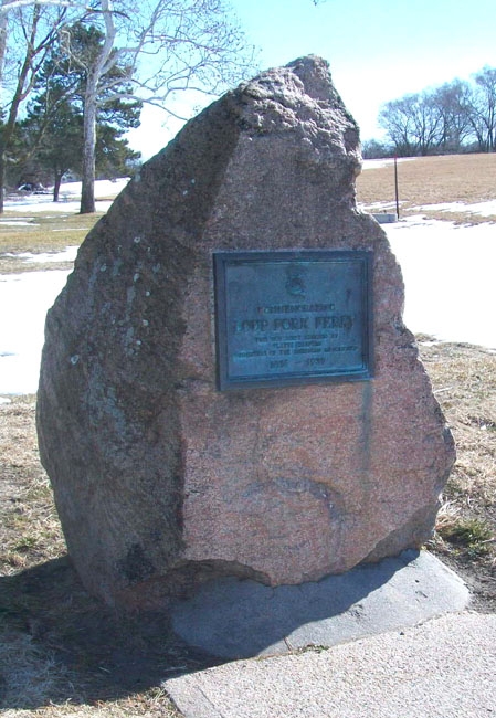
When emigrants left Council Bluffs, they were traveling on the North side of the Platte River. At the current location of Columbus, Nebraska they encountered the Loup River and either followed it for a while or crossed it. There is a marker commemorating the Loup River ferry located in Pawnee Park (GPS coordinates -97.362, 41.418). If emigrants didn’t cross here they would continue another thirty or fifty miles to other locations to cross the Loup River and return to the Platte.
Lemuel Clarke McKeeby (https://www.jstor.org/stable/25613602?seq=1) wrote, on May 18, 1850, about one of the crossings further upstream: “We drove 30 miles today and arrived at the ford of the Loup Fork of the Platte River. The river here is about half a mile wide with quicksand bed, and the only way to make the crossing is by keeping the team on the move. Our wagon was selected to go over first, it being the lightest. The water was from six inches to two feet deep; the bank was steep and the water deep where we started in. In we went and broke our forward bolster, but we could not stop and must go on or sink in the sand. When we got about midway our wagon body shoved over on the forward wheels and this brought us to a halt and down went horses and wagon in the quicksand. Our horses and wagon sunk almost out of sight; all hands turned in to help, and we got our horses out and brought the wagon and our outfit over by piecemeal. All the other wagons put six horses on and the whole party got safely over. All hands very tired; we go into camp and enjoy a good nights sleep, leaving the usual guard on duty.”
May 31 – A 5-month virtual road trip along the California Trail
All roads along the westward Trails converged on either the north or south sides of the Platte River. We conclude the May portion of our virtual journey by visiting the grave of Susan Hail (GPS coordinates -98.724, 40.655) at the point where the Independence / St. Joseph road meets the Platte River road. The historic marker database (https://www.hmdb.org/m.asp?m=123807) has a good description of the gravesite and that is where the pictures were downloaded.
William Woodhams (https://history.nebraska.gov/sites/history.nebraska.gov/files/doc/publications/NH1980WHWoodhams.pdf) noted the grave on May 10, 1854: “Left Little Blue this morning for the Platte River valley. Travelled all day over a high rolling prairie; no wood or water fit to use. Saw plenty of wolves, and passed many graves. One had a nice marble head stone with a woman’s name on it. It stood on the top of a little sandhill, and strange enough was that sad evidence of civilization here in the wilderness, the more so as it bore a woman’s name. Bad enough for man to be buried in this wild region, but a woman’s place seems peculiarly in the comforts of home and friends. One head board we saw told the occupant below had been killed by lightning.”

