May 8 – A 5-month virtual road trip along the California Trail
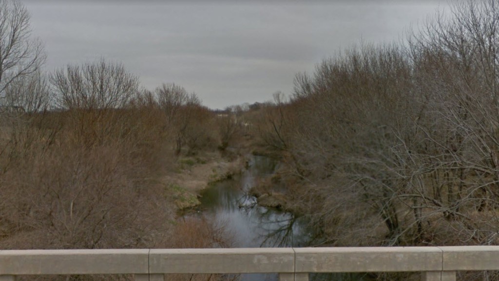
The California Trail crossed the Wakarusa River in at least three places just south and southeast of Lawrence, KS. There are no historical markers at this site that I am aware of, but you can drive across a bridge on east 1400 road (GPS coordinates -95.242, 38.912) and view the river and its steep banks. The photo is from Google Maps Streetview on the bridge crossing the river. Just north of this location are the Baker University wetlands and Discovery Center (https://www.bakeru.edu/history-traditions/the-wetlands/).
Bennett C. Clark, in 1849, wrote: “May 5 – Left camp early, the road being worse than we had yet found it, and after hard driving and having passed several Origon and California trains, we encamped on Wakerusia Creek, a beautiful stream of clear water the banks of either side being very bad on account of their height and abruptness. May 6 – Geard up and made ready for crossing the creek. All being in readiness, the morning being fine, the train moved on to the creek, two wagons moving down into the bed of the creek at the same time, & after great labour & difficulty the train all crossed and moved on through a low marshy bottom about two miles wide and gained the high prairie where the road was in good condition and travelling easy.”
May 9 – A 5-month virtual road trip along the California Trail
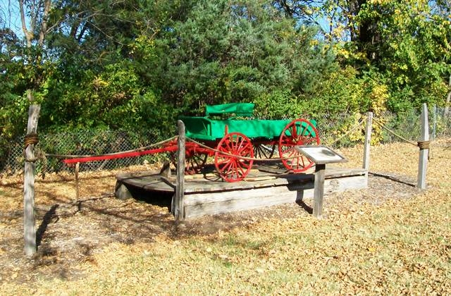
A replica of Pappan’s Ferry can be found at the north end of the parking lot for the Old Prairie Town at Ward-Meade Historic Site and Botanical Garden (http://parks.snco.us/Facilities/Facility/Details/28 GPS coordinates -95.683, 39.064). The inscription on the accompanying marker says, “Travelers on the Oregon Trail encountered the first major obstacle of their journey when they reached the Kansas River. In 1842, Joseph and Louis Pappan established a ferry operation across the river. The ferry, at one time, was directly behind the original Ward cabin at the foot of Western Street on the south bank of the river. The ferry was attached to ropes across the river, which were used to navigate it. The Pappan brothers charged $1 per wagon. Their ferry crossing operation was invaluable and profitable. This is a replica of an early ferry on the Kansas River.” The photo is from the Historical Marker Database (https://www.hmdb.org/m.asp?m=65025).
John E. Dalton (https://www.octa-journals.org/merrill-mattes-collection/diary-john-e-dalton-1852) wrote on May 14, 1852, “Started at sunrise & had a race with and passed a train of 12 waggons bound for Oregon, which had camped one mile ahead of us – took no breakfast – came to Kansas River 6 miles, about 10 o’clock – and soon commenced crossing the ferry (Papins); got all over about 4 o’clock; went on two miles and camped.”
May 10 – A 5-month virtual road trip along the California Trail
The Kansas Museum of History (https://www.kshs.org/museum GPS coordinates -95.774, 39.056 ) is a great place to learn about the early portion of the California Trail and to conduct research in the state’s historical archives. The photograph comes from the Google Maps collection of photographs of the interior of the museum.
William R. Kelly’s journal, held in the Library of Congress (https://www.loc.gov/item/rc01000799/) contains a nice exposition of travel along the Independence Road that we’ve visited so far in our virtual journey, including the Lone Elm camp, crossing the Wakarusa, and another ferry across the Kansas River. In Chapter 4 he wrote about the region we’re in now: “The country now for some miles became hilly and broken, covered with a debris of gravel and loose round stones, of a dark reddish tint. There was one very elevated bluff, called “Coon Point,” at the foot of which stands an abyss, with very good water; but we pushed on to a place called “Prairie Spring,” situated at the head of a grassy ravine, from which we startled a small herd of deer that were slaking their thirst at the clear fountain. One of our party also flushed and shot a brace of prairie hens, a fine bird, somewhat larger than our grouse, but resembling it closely in shape and plumage; the flavour of their flesh was exquisitely delicate, forming a very welcome addition to our otherwise invariable fare of fried bacon.”

May 11 – A 5-month virtual road trip along the California Trail
You can drive along the Oregon Trail Road from St. Mary’s to Louisville, Kansas, a distance of about 16 miles. Along it you will cross a number of tributaries of the Kansas River. In this stretch of road there is a park called Oregon Trail Nature Park (GPS coordinates -96.153, 39.229) in which you can walk and reflect on the experiences of the emigrants. The photo is from Google Maps Streetview. It was in this region that Amos Josselyn (https://www.octa-journals.org/cave-springs-collection/diary-amos-piatt-josselyn-1849) wrote, on May 11, 1849, “We yesterday lost 3 of our mules and in looking for them I got too far from camp and it getting dark before I could get in I lost my way and spent the night in rambling about. I had to move about to keep warm. I tried to sleep two or three times but it was too cold. I got into camp about 7 o’clock this morning and found that the mules were in. They were brot in by three Indians who said they cought some Indians off another tribe driving them off. They wanted $9 for returning them but took five. Hitched up our teems and drove to Turkey Creek about 20 miles where we understood there was some companies waiting for more company but on arriving found none. The weather fine and roads tolerable.”

May 12 – A 5-month virtual road trip along the California Trail
Many emigrant diaries mention the Vermillion River crossing. Today as you drive the Oregon Trail Road (virtually) through the region you’ll cross the river and find the Vieux Elm Park (http://www.kansastravel.org/viewcrossing.htm GPS coordinates -96.251, 39.256) just on the west bank. The west side of the river was the first major campsite about a days journey from St. Mary’s Mission, and many stayed here overnight. There were several cholera outbreaks in the area and in 1849 about 50 cholera victims were buried near the bank of the river. This impromptu cemetery was also used for others who died along the trail. There are 3 grave markers there today. Fording the river was difficult and risky. Wagons had to be lowered down the steep bank with ropes, floated across the Vermillion River and hauled up the other side, while livestock waded or swam across the sometimes swift current. A large wagon train might take two days to cross.
Edwin Bryant (https://archive.org/details/whatisawincalifoin00brya) wrote on May 25, 1846, “Our route to-day has been over a more broken country than I have seen since entering upon the prairies. The timber fringing the margin of Vermilion Creek, seen in the distance, has been the only relief to the nakedness of the country, with the exception of two or three solitary trees, standing isolated on the verdant plain. We reached the Vermilion about noon. The bank of this stream on the eastern side was so steep, and the ford in other respects so difficult, that we were detained several hours in crossing it. The Vermilion is the largest watercourse we have crossed since leaving the Kansas. Its current is more rapid than has been usually exhibited by the streams of these prairies, and would afford very good water-power. The timber at this point on its banks, is about a quarter of a mile in width, and consists chiefly of oak and elm. It has been reported to be abundantly supplied with a variety of fish. Ewing and Nuttall, who encamped with an emigrant party here last night, caught two good-sized catfish, but none of a different species.”

May 13 – A 5-month virtual road trip along the California Trail
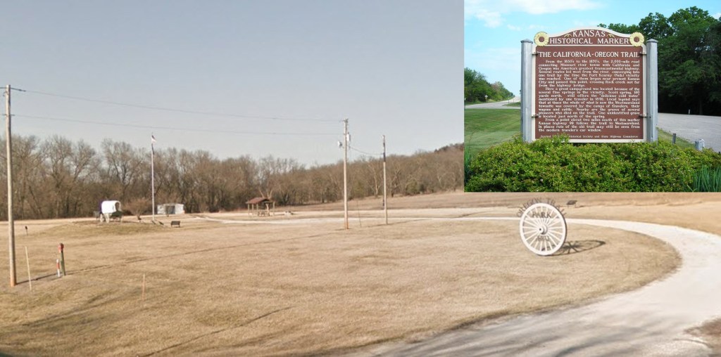
Oregon Trail Park at Scott Spring (GPS coordinates -96.406, 39.383) is located on the “Road to Oz” Highway (Highway 99) just south of Westmoreland, KS. There are a number of interpretive panels there as well as a State Historical Marker just south of the park. In addition to the interpretive panels, you can see a covered wagon replica, an emigrant grave, and walk a footpath along Rock Creek and Scott Spring. The photographs are from Google Maps Streetview.
It was somewhere in this vicinity that Helen Carpenter (https://www.octa-journals.org/merrill-mattes-collection/a-trip-across-the-plains-in-an-ox-wagon-helen-carpenter-1857) wrote, on June 3, 1857, “It has been too cold for sewing and the road has been so rough and uneven that I accomplished but little with the needle – if it were not for my dire necessity, would give it up as a bad job. The horses travel faster than the oxen, which enables Uncle Sam to go ahead and find stopping places. There was plenty of water in a ravine where the train stopped for the nooning. During the afternoon three horribly muddy ditches were crossed – Fathers wagon was broken in one of them, and the little stove which was fastened on the back of the wagon, got pretty well smashed up. They have succeeded in straightening it up so it will still be of some service. After getting through the muddy ditches, the road was both stony and sandy. Passed a stream of running water, and then when camping time came, had to go three fourths of a mile from the road, to find water full of wiggle tails at that – almost no wood. Saw four wolves.”
May 14 – A 5-month virtual road trip along the California Trail
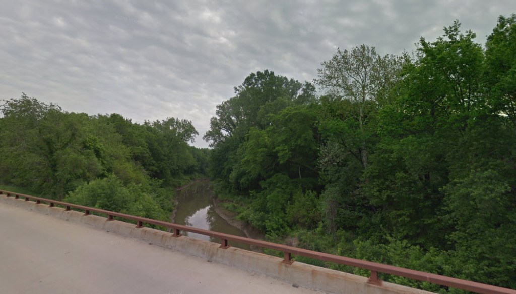
The Black Vermillion River is mentioned frequently in emigrant diaries. The photo is from Google Maps Streetview where Highway 99 crosses the river just south of Frankfurt, KS. This is about five miles northeast of where the Trail actually crossed the river, which is at GPS coordinates -96.487, 39.646. In 1849 Samuel Murray Stover (https://www.octa-journals.org/merrill-mattes-collection/diary-of-samuel-murray-stover-1849) wrote, “May 25th – Made new road to cross the creek. Wood sick. Came 10 miles, camped in two miles of a creek, fine spring right of the road. Remarkably cold. May 26th – Crossed the creek, came eight miles to Vermillion. made a soft bridge by cutting down timber and laying on rails. Come up with an ox train. Cholera at the crossing. Five or six graves on the banks. Wood died at 10 o’clock with cholera. Another death in the ox train. May 27th – Committed the remains of our comrade H. A. Wood to the silence of the grave on the east bank of the stream by the side of the other dead, placed at his head a stone on which his name is engraved. Wood was from Asheville, N. C. Crossed the creek by unloading our wagons and carrying it across our soft bridge, then shoved the wagons across and pulled them up the bank with ropes. In ordinary times the creek can be forded. Pioneer train cross their baggage in a boat made of a wagon bed, drove their wagons thru the creek. Came one mile on the plains. some sickness in camp.”