September 8 – A 5-month virtual road trip along the California Trail
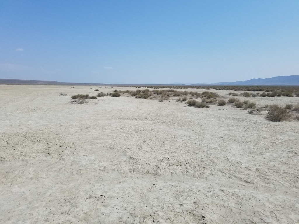
Continuing on the Applegate Trail from Rabbit Hole Spring we next encounter High Rock Canyon (GPS coordinates -119.413, 41.389). The Friends of Black Rock/High Rock website (https://blackrockdesert.org/high-rock-canyon/) has a nice introduction and description, as does the Bureau of Land Management website (https://www.blm.gov/visit/high-rock-canyon). The accompanying photograph is from the blackrockdesert.org website.
Joseph Sedgley (https://babel.hathitrust.org/cgi/pt?id=njp.32101074863992&view=1up&seq=1&skin=2021) passed through the canyon on August 28-29, 1849: “Aug 28 – We passed rugged mountains for five miles, then went through a gap between two high ranges of solid rock, in which there was good grass, and a distance of three miles in the gap brought us to water. There is an eagle’s nest seventy-five feet up the perpendicular face of the cliff. One mile further and we came to a creek, which we crossed. Continued along the gap three miles further, and found a pure spring of water, on the right of the trail, where we camped. Distance, sixteen miles. Aug 29 – Traveled up the gap ten miles and halted, with good grass and water. The gap is very narrow in places, the walls rising perpendicularly 300 feet. Five miles up the gap is a fine spring of pure water, near the trail, to the right. From there we passed through a canyon three miles, and found it hard to travel. Then forded the creek. Thence over hills and valleys seven miles, and descended into a rich valley, clothed with grasses. Here we camped. Distance, twenty-five miles. Passed one hundred wagons.”

September 9 – A 5-month virtual road trip along the California Trail
As discussed on September 5, the Applegate Trail was originally established as an alternate route to southern Oregon Territory. Peter Lassen, though, saw the opportunity to divert travelers to his ranch in northern California and make some money off of them. He, similar to Lansford Hastings and his Hastings Cutoff, proposed the Lassen Cutoff – a route that he had not actually traveled. In 1848 he traveled to Fort Hall and led a group of wagons along the Applegate Trail until until in the vicinity of Goose Lake (GPS coordinates -120.376, 41.733) and then attempted blazing a new trail toward his ranch. After much trouble and eventual help from travelers heading south from Oregon, he finally reached his ranch. The photo of Goose Lake is from https://en.wikipedia.org/wiki/Goose_Lake_Valley.
Stillman Churchill (https://contentdm.lib.byu.edu/digital/collection/Diaries/id/4878) followed Lassen’s route in 1849. He wrote, “Sept. 10 – … road hilly and rocky when we struck Goose Lake. It is 6 or 8 miles long with a plenty of game arround it. The hills on the left are low grass plenty water good nooned here & passed on 8 miles and camped on a stream of clear pure water grass good. We here came up with Mr. Reeds train of mules they left us on Bear River distant from this point from 7 to 8 hundred miles. Distance 16 miles. Sept. 11 – Weather fair, left camp at 6 A.M. road good with the exception of some small stones road descending our course is somewhat winding on the whole leading us southwest grass plenty have followed a stream all day. Distance 20 miles.”

September 10 – A 5-month virtual road trip along the California Trail
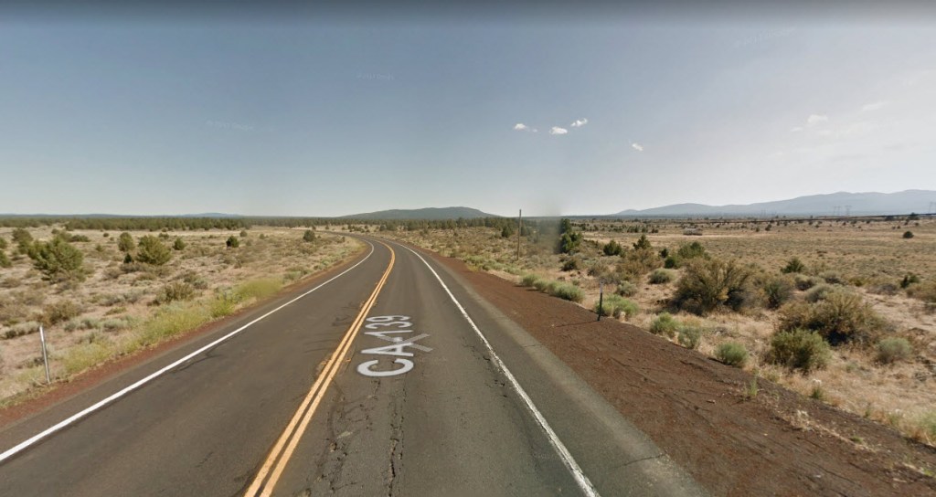
Before we finish following Lassen’s Cutoff there are two other entry points into California that should be mentioned – the Burnett Cutoff (today’s topic) and the Yreka Trail (to be discussed tomorrow). The Trails West, Inc. guide to the Lassen Trail and Burnett Cutoff (https://emigranttrailswest.org/trail-guides-for-purchase/lassen-burnett/) provides good background on Peter Burnett’s decision to attempt to establish a wagon road from southern Oregon to California. A pack-trail already existed, but he saw a need for a route which would better accommodate wagons. In the fall of 1848 he led a wagon train down the northern section of the Applegate Trail and then branched off to form the Burnett Cutoff (GPS coordinates -121.220, 41.625). California highway 139 roughly follows this cutoff and the photograph is taken from Google Maps along that highway.
Peter Burnett (https://www.loc.gov/item/01006673/) wrote in his memoirs: “I was elected captain of the wagon-party, and Thomas McKay was employed as pilot. We followed the Applegate route to Klamath Lake, where we left that road and took a southern direction. Thomas McKay, myself, and five others, well armed and mounted, went on in advance of the wagons to discover the best route, leaving the wagons to follow our trail until otherwise notified. We, the road-hunters, took with us plenty of flour, sugar, and tea, and depended upon our guns for meat. We passed over comparatively smooth prairie for some distance. One evening we encamped at what was then called Goose Lake. It being late in the season, the water in the lake was very low, muddy, and almost putrid. Vast flocks of pelicans were visiting this lake at that time, on their way south. I remember that we killed one on the wing with a rifle.”
September 11 – A 5-month virtual road trip along the California Trail
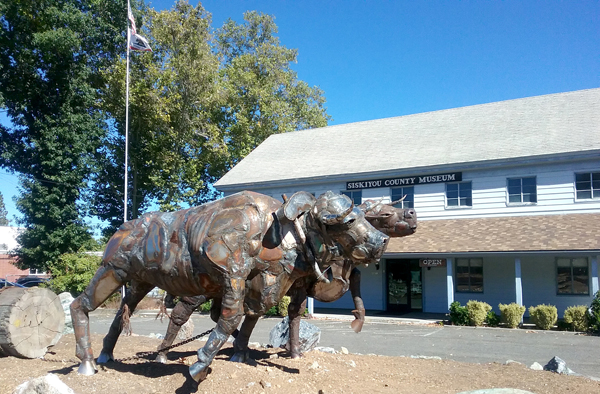
Another branch off the Applegate Trail was the Yreka Trail, leading to the gold fields around Yreka, California which opened in 1851. You can read an introduction to that trail on the website of the California/Nevada chapter of OCTA at http://canvocta.org/emigrant-trails-of-nevada-and-california/yreka-trail/. While in Yreka, be sure to visit the Siskiyou County Museum (GPS coordinates -122.6383961905483, 41.72387644179084) and their website (https://www.co.siskiyou.ca.us/museum). The accompanying photo was downloaded from the Friends of the Museum website at http://siskiyoucountymuseumfriends.org/.
Lucius Fairchild went to California during the 1849 gold rush. He then went to Yreka to establish a ranching (beef and agriculture) business when gold was discovered there. Later in his life he returned to the eastern States and became governor of Wisconsin. Letters that he wrote from California are preserved in the Library of Congress (https://www.loc.gov/item/31033125/). He wrote “You may want to know what my chances are for the “Pile” I am after, well they were never better, in fact untill I entered into partnership with Mr. Steele & left the Boys entirely I always went to work wrong end first. But for the last year, we have set to work right and have made money fast if our crops turnout well this year, we will be rich cirtain, but if they fail, woe be unto us. Our Ranch is being improved largely, about 100 acres under cultivation & 300 under fence a good house, barn, Grainery, and all the out houses appertaining to a farm. We Butcher in the Valley, Keep stable in Yreka, Keep tavern, trade in all kinds of stock, Butcher here, Mining the Richest claim ever struck on this river, engaged in building a sawmill here which will pay well, & looking out for chances to make a spec. all of the time. You may think we have some Irons in the fire but we manage to Keep them all in good order by hard work. I attend to all of the business here. Steele in the Valley & Yreka If we have good luck all round we can close up with ten or fifteen thousand dollars apeece. Still I do not make any Calculation on such an amount, but will give it the best turn I can. We have now about $14000 clear of debt, all made in 15 months.”
September 12 – A 5-month virtual road trip along the California Trail
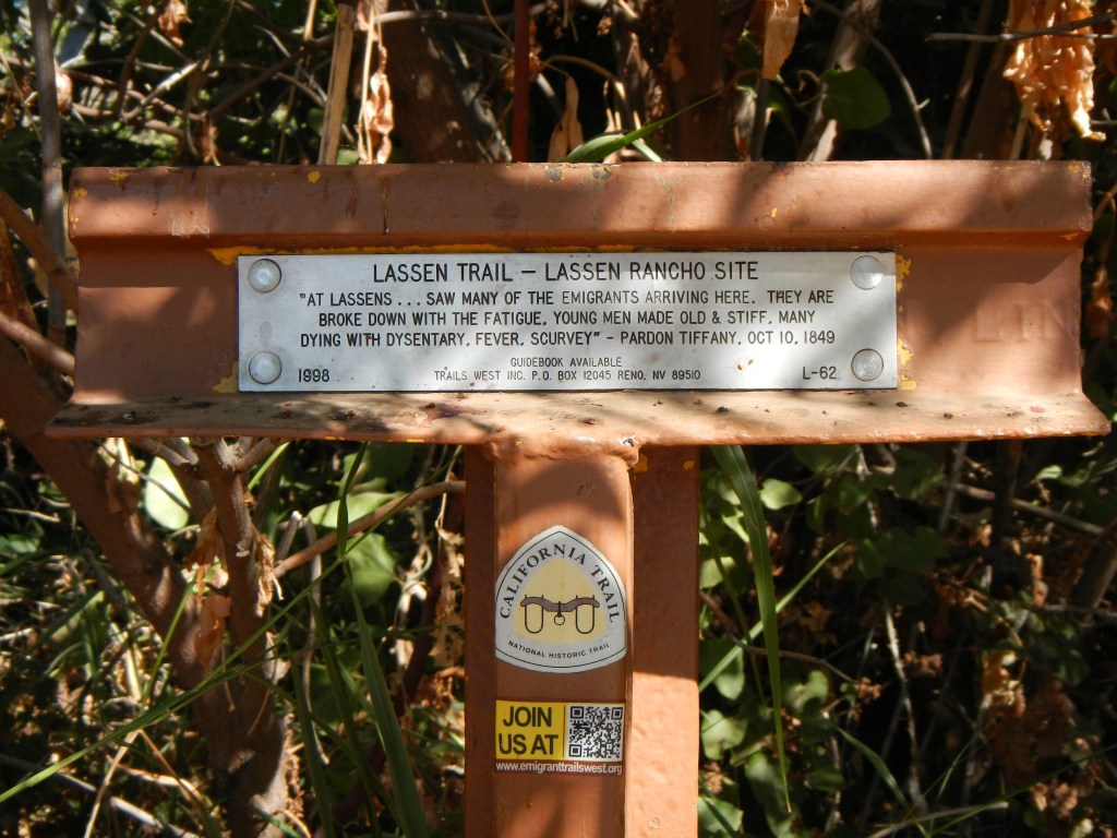
We visited Lassen’s cutoff from the Applegate Trail on September 9. Today we’ll look at where Peter Lassen’s ranch was located – the ultimate lure to get people to travel the Lassen Trail. You’ll only find a Trails West T-Rail Marker at the site today (GPS coordinates -122.058, 39.934). Of course Peter Lassen’s name appears on many features and sites in Northern California. Another place you might find interesting is Lassen’s gravesite (GPS coordinates -120.640, 40.351). There are interpretive signs and a grave marker there, described on the Historical Marker Database at https://www.hmdb.org/m.asp?m=31740. The Trails West Marker photo came from the same website at https://www.hmdb.org/m.asp?m=89185.
Benjamin Biddle (https://donduncan.org/trails/biddle.htm) wrote on September 10, 1849, “At 8 A. M. after some repairs of our wagons, we proceeded onward. Weather warm. At 10 1/2 we entered the great and beautiful valley of the Sacramento. We stopped a moment and unfurled the Star Spangled Banner from wagon No. 1. At 12 we nooned at Deer Creek, where there was plenty of grass. Afternoon proceeded and at 3 p. m. halted within a mile of Mr. Lawson’s settlement. This is the first settlement we have seen in California. He is a German—speaks English well—and is rapidly accumulating a fortune here. His stock are worth $60,000. We have some gentlemen from the mines in our camp. They speak encouragingly of the prospects for obtaining gold. We are now sixty miles from the mines.”
September 13 – A 5-month virtual road trip along the California Trail
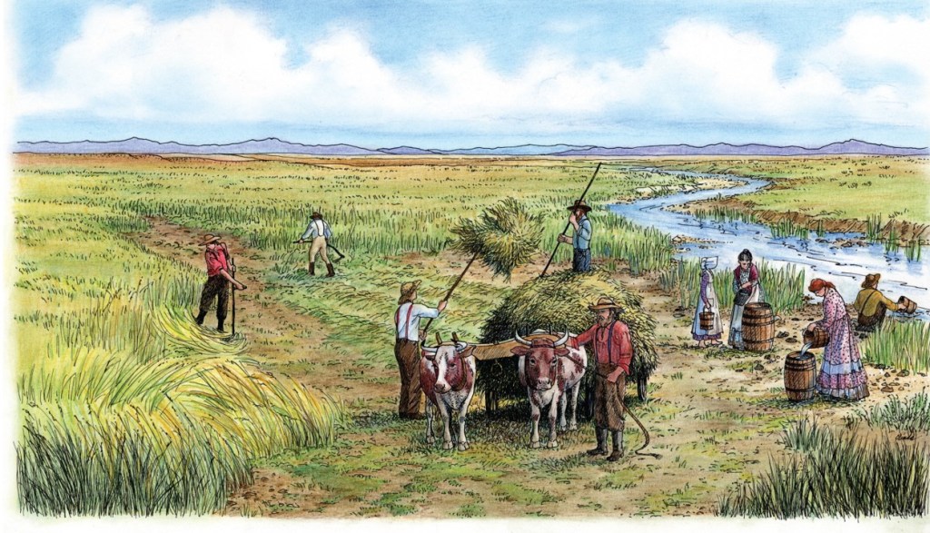
Now that we’ve explored some of the various routes into California branching off of the Applegate Trail we return today to the main Trail back in Nevada. Emigrants have been traveling along the Humboldt River for nearly 300 miles across the Great Basin and have almost reached the dreaded “40-mile desert”. The region where Lovelock, Nevada now resides was known in those days as the “Big Meadow”. It was where emigrants could take advantage of plentiful grass and cut hay for transport across the desert to use as fodder for their animals along the way. The accompanying illustration is from the wayside exhibit on the grounds of the Marzen House Museum (GPS coordinates -118.482,40.170).
Henry W. Starr (https://www.octa-journals.org/merrill-mattes-collection/diary-of-henry-w-starr-1850) wrote on August 25, 1850, “We started at 4 o clock determined to make the Slough where we could get some grass for our starving Cattle we traveled some 6 miles and halted for breakfast after breakfast we drove 2 miles further and found plenty of Slough grass and stopped to recruit our stock and lay in grass for the big desert in getting grass here we have to wade ½ of a mile through Watter knee deep to the main Slough and then go in up to our necks and cut the grass and cary it out but by the time a man gets thus far on an overland Journey to California he can endure any kind of hardships without murmuring.”
September 14 – A 5-month virtual road trip along the California Trail
The dreaded 40-mile desert was not the longest desert emigrants had encountered during their journey, but it was notorious for being one of the hardest to cross. The primary reason was that it was near the end and people and animals alike were simply worn out! The Fallon Rest Area (GPS coordinates -118.750, 39.941) off of Interstate 80 at the U.S. 95 exit is good place to get a sense of the desert crossing. Here emigrants would head across to intercept either the Truckee River or the Carson River to wind their way across the Sierra Nevadas. It was here that the Humboldt River would “sink” into a marsh and the water would either evaporate or simply sink into the desert sands. The photograph by Trail Center staff is near Highway 95 looking east toward the Humboldt Sink.
James S. Abell wrote in 1849: “August 22 – Hard times last Night, Misquitoes in abundance and was very crowded … about 9 oclock we Started, I went ahead of our team and took dinner with Bidwell & co. we reached Sulphur Springs which was a little beyond the Sink of Humboldt river (about 5 miles I should think). This was truly a dreary place the water was filled with all kinds of impurities and not a green thing in Sight we reach the Spring about 4 hours and then pushed on until 2 oclock. August 23 – the next morning when we Stopped about 2 hours and then pushed on for the boiling Springs where I arrived long before our wagon. To describe this place would be impossible, cattle dead and dying the air full of the odor of rotting carr[i]on and the water being thrown 3 and 4 feet from the ground by heat desolation reigned Supreme. these Springs are about 25 Miles from Sulphur Springs. I remained here until nearly Sundown cooling water for our team by pouring water from a dish into tubs and other vessels that had been used there for that purpose. At 7 oclock we left the Spring (PM) made a halt of 1 hour from 10 oc to Eleven PM. then went on until 2 oclock AM.”