
June 1 – A 5-month virtual road trip along the California Trail
Fort Kearney (http://outdoornebraska.gov/fortkearny/ GPS coordinates -99.005, 40.645) was established along the Oregon/California Trail in 1848. Today you can visit an Interpretive Center, view the parade grounds and several reconstructed buildings. Note that this Fort Kearney should be distinguished from “Old Fort Kearney” which was located where Nebraska City developed (see the May 4 Facebook post about that.) You might be interested in the 1948 article “Fort Kearny and the Westward Movement” from Nebraska History Magazine (http://www.nebraskahistory.org/publish/publicat/history/full-text/NH1948FtKearny.pdf).
On June 22,1849 Herman B. Scharmann (https://www.loc.gov/item/19005305/) wrote (originally in German but translated into English), “On June twenty-second we reached Fort Kearney, where we rested for two days. The fort, like all the other buildings around here, is built of dried bricks. It is garrisoned by three companies of soldiers and guarded by several guns, in order to keep a check on the numerous Indians of this neighborhood. The site is on an immense plateau thickly covered with grass which could serve as a dwelling-place for an almost unlimited number of human beings, since the cultivation of this land and the raising of cattle would amply recompense them all within a few years. I went to the commander of the fort and asked him for some fresh bread to satisfy my wife’s longing. In the most accommodating and courteous way he supplied me with an order on the quartermaster’s department, where I obtained fifteen pounds of fresh bread very cheaply.” The photograph was downloaded from Google Maps Streetview at https://www.google.com/maps/place/Fort+Kearny+State+Historical+Park/@40.6436709,-99.0112598,3045m/data=!3m1!1e3!4m5!3m4!1s0x879947d3dd9fa945:0x3e8209885a1b6254!8m2!3d40.6436709!4d-99.0050695.

June 2 – A 5-month virtual road trip along the California Trail
The Archway Monument Museum (https://archway.org/ GPS coordinates -99.039, 40.670) stretches across Interstate 80 in Kearney, Nebraska. Their website describes it in this way: “The heart of the Archway experience is our historical exhibit that pays tribute to the American spirit of adventure. Using life size figures and personal audio guides, the Archway tells the story of the building of America. At the Archway, you’ll walk with the pioneers over the Oregon Trail. Watch a rider switch horses at a Pony Express Station. Hear Mark Twain’s account of a cross country stage coach trip. Relive the driving of the “Golden Spike” that united the nation’s railroads. Visit a traveler’s campground to hear stories of life on “America’s Main Street,” the Lincoln Highway.” You can view a short video on YouTube at https://www.youtube.com/watch?v=Xk9d4gLe6AI&t=52s.
James F. Meline (https://www.octa-journals.org/merrill-mattes-collection/two-thousand-miles-on-horseback-by-james-f-meline) wrote in a letter dated June 7, 1866: “The first hundred miles (the whole distance from Leavenworth to Fort Kearney is two hundred and ninety-four miles) of the route, is to some extent through a settled country. The soil, black as your hat, is so rich that the earth looks as though it would laugh if you tickled it. New farms are evidently increasing rapidly, as the road itself shows. Being public domain, travellers have followed the most favorable undulations of the ground, without reference to the quantity of land covered. But as new farms are made, we find ourselves sent right or left, down hill or up, by the inclosure of the old route. We passed many newly fenced fields that have taken in large sections of the road.”

June 3 – A 5-month virtual road trip along the California Trail
There are rest areas on both the eastbound and westbound sides of I-80 near Sutherland, Nebraska. While both contain an interpretive sign about the Platte River Road, the eastbound side (GPS coordinates -101.096, 41.138) has an additional sign (“Crossing the Overland Trail”) and also has a trail out to some ruts that still remain which traversed next to O’Fallons Bluff southeast of the rest area. On June 13, 1864 Garland Jefferson Mahan (https://www.octa-journals.org/merrill-mattes-collection/diary-of-garland-jefferson-mahan-oxen-train-from-cole-county-missouri) wrote, “Today passed O’Fallons Bluff. Nothing more than a ranch and a trading post at the base of low sandy bluffs. Here river runs to river thence turning off through bluffs for 8 miles then back to Platte bottom. After travelling till 5:30 camped. Thunder storms came up interfered with supper, a good deal wet us. Lay down to sleep with wet clothes on, slept right well after they dried. Traveled 16 miles.” Mahan’s statement about “river runs to river” is probably a reference to the fact that the road on the south side of the South Platte river here leaves the river bottom for about 8 miles before returning to the river. Mahan continued his journey on the south side of the South Platte until reaching the Julesburg, Colorado area to cross the South Platte there. We’ll “virtually” visit that location on June 8. The photo is from Google Maps Streetview at https://www.google.com/maps/place/Rest+Area+-+I-80E+MM+159/@41.1388966,-101.1018273,2796m/data=!3m1!1e3!4m5!3m4!1s0x8776438c7ccea825:0x6bd18daff45a1490!8m2!3d41.1390048!4d-101.0967454.

June 4 – A 5-month virtual road trip along the California Trail
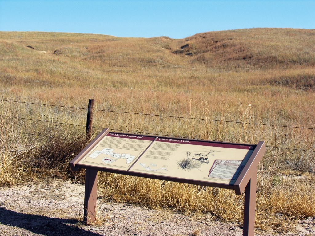
Travelers on the Mormon Pioneer travel were remaining on the north side of the North Platte river. About 3.8 miles north of Sutherland, Nebraska you can visit a roadside interpretive display and view ruts passing down the hill east of the road (GPS coordinates -101.117, 41.215). The photograph is used in the National Park Service Nebraska Trails Auto Tour Guide and was downloaded from https://commons.wikimedia.org/wiki/File:D-8._The_Sand_Hill_Ruts_(4_miles_north_of_Sutherland)_on_the_California_and_Mormon_Pioneer_National_Historic_Trails_(2005)_(816df4bc-537d-4bbd-8378-4dc965c8d591).jpg.
It was near this site that G. W. Thissell (https://www.octa-journals.org/merrill-mattes-collection/journal-of-g-w-thissell-1850) wrote on May 21, 1850: “This morning we had an exciting time. Three buffalo ran into our camp. All hands rushed for their guns, but not until twenty balls had entered his hide did one of the buffalo come to the ground. In twenty minutes his hide was off and his carcass in the wagons. At night we jerked the meat. This is done by driving four small forks of wood into the ground. A frame of sticks is then made. The meat is cut in thin strips, then dipped in hot brine and hung over the sticks. A small fire is made under the frame, and from the heat the meat is quickly dried. This is called jerked buffalo meat. On this the emigrants lived fine. Every emigrant, before leaving for California in ’49-’50, equipped himself with some kind of a gun, with which to protect himself from the Indians, as well as to shoot wild game. Hence there were firearms of all descriptions, – double and single-barreled shotguns and smooth-bore and double-twisted rifles. The favorite gun was the old Kentucky rifle, with a barrel three feet long, that carried sixty balls to the pound. Then there was the blunderbuss of the War of 1812. Jim Stoaks selected a blunderbuss. It was short, light, and handy. It was a dangerous looking gun. It looked as if it would kill everything it was pointed at. It was a smooth bore and carried a half-ounce ball…. Jim became impatient to try his gun, and turned it loose on the buffalo. They were not one-fourth of a mile away. Jim got under the bank of a creek and crept up to within fifty yards of them. He took sight with both eyes open, and shaking like a trembling aspen leaf, he pulled the trigger. It was flint lock, and it missed fire. Jim picked the flint and took aim once more, expecting to blow a hole clear through that buffalo. There was a roar, then a crash, and Jim landed in the bed of the creek, while the gun lay on the opposite bank. When the smoke cleared away, Jim looked for his buffalo, and was just in time to see the herd go over the hill a mile away. Not a hair on their hide had been hurt. Should Jim Stoaks live to be as old as Methuselah, he will never forget the buffalo he did not kill.
June 5 – A 5-month virtual road trip along the California Trail
California Hill (GPS coordinates -101.980, 41.100) was a route that led up the bluffs from one of the primary crossing points of the South Platte river on the way toward Ash Hollow on the bank of the North Platte river. Ruts are still visible and a state historical marker is located on Highway 30 about 2/3 of a mile south of the Hill.
In 1857 Helen Carpenter (https://www.octa-journals.org/merrill-mattes-collection/a-trip-across-the-plains-in-an-ox-wagon-helen-carpenter-1857) wrote a very detailed account of the South Platte crossing and then the ascent of California Hill. On June 22 she wrote, “There was neither time nor inclination to write more yesterday – it was night before all were across the river, and then supper had to be gotten and the damp things pulled out of the wagon etc. etc. and everybody dead tired – The first team was an hour in making the trip, and the distance (the way we had to go), was a mile. Those who had just crossed, said it would be necessary for us to double teams – this being done, only two wagons could go at the same time – which made it necessary for all the drivers and oxen to cross the stream three times…. Where we went down into the water, the river bank was steep and about four feet high – so on our first entrance into the stream, the wagon came so near standing on end, that all view of the team was cut off for a few seconds and there could be seen only the muddy water well up to the wagon bed. When the wagon was righted, there was little to reassure us. The water runs very swiftly, and that together with the sand washing from under the wheels, or the wheels settling into the quicksand, caused a shaking trembling sensation that was truly terrifying. There were four drivers to each wagon, yet it was difficult to keep the cattle moving in the right direction, as they bore off down stream on account of the swiftness of the water – if they halted for just a moment, they had difficulty in getting their feet out of the quicksand, and the settling down of the wagon could be plainly felt. In places the water was midway of the wagon beds – in this great expanse of muddy water there was no telling the deep places from the shallow ones.” She continues on for several more pages. Then, the next day she wrote, “The bluff we had to ascend to get on the dividing ridge between North and South Platte, was very high and very steep in places. The road was necessarily sandy as the whole country is little but sand.”

June 6 – A 5-month virtual road trip along the California Trail
Windlass Hill, a part of Ash Hollow State Historical Park (http://outdoornebraska.gov/ashhollow/) in Nebraska (GPS coordinates -102.114, 41.259), is a steep descent from the dividing ridge between the South Platte and the North Platte. Today there is a popular hiking trail to the top from which you can still see the ruts of the descent. These are especially visible from an aerial view such as the screenshot from Google Earth shown in the right-hand photo. The left-hand photo is from Google Maps Streetview at https://www.google.com/maps/place/Windlass+Hill/@41.2609703,-102.1163174,349m/data=!3m1!1e3!4m12!1m6!3m5!1s0x8776438c7ccea825:0x6bd18daff45a1490!2sRest+Area+-+I-80E+MM+159!8m2!3d41.1390048!4d-101.0967454!3m4!1s0x87712a8ae45672bb:0x8ec392206e19711d!8m2!3d41.2609703!4d-102.1153972.
Charles A. Scott (https://issuu.com/utah10/docs/uhq_volume28_1960_number2/s/97797) described, on August 27, 1857, “A general runaway and smash up at Ash Hollow, a terrific scene. Horses dashing furiously with the pieces down the hills and precipeces the noise, dust and confusion, the men shouting hallooing, the women screaming, made an impression on my memory, never to be effaced. Two horses were killed and seven disabled and unfit for service, in all about $25,000 damage done. Camped on the north fork of the Platte.”

June 7 – A 5-month virtual road trip along the California Trail
According to the Nebraska State Parks website, “Sweet spring water made Ash Hollow State Historical Park (http://outdoornebraska.gov/ashhollow/ GPS coordinates -102.122, 41.305) near Lewellen a major stopover on the Oregon and California trails and prompted prehistoric Indians to use it, too. Ruts etched by west-bound wagons are still visible on the bluffs. Today, the area’s beauty and sweeping vistas continue to make this area a popular destination for vacationers and travelers. The history, archaeology and paleontology of the area are interpreted at the visitor center, Ash Hollow Cave and exhibits and structures.” There is also a cemetery onsite. The photograph is from Google Maps Streetview at https://www.google.com/maps/place/Ash+Hollow+State+Historical+Park/@41.2960339,-102.1476023,12061m/data=!3m1!1e3!4m5!3m4!1s0x8770d59f2e1c84a9:0x804ce56c33003d17!8m2!3d41.2960339!4d-102.1228454
On June 10, 1852, Holmes D. Van Schaick (https://www.octa-journals.org/merrill-mattes-collection/diary-of-holmes-d-van-schaick-1852) wrote, “Having our provision to repack we did not roll out of camp till 8 Oclock, We traveled a NW course till we reached Ash hollow, (a distance of 16 miles from the Platte). We here had to descend 100 ft in going about 10 rods; this brought us in the hollow. This valley is from 30 to 50 rods wide and 2 miles long, On one side the ledge of Granite is about 200 feet high, the other side was variable In this valley we found three kinds of wild roses, wild Onions, Choke Cherries, black Cherries, wild Currants, Grapes, Ash, and Cotton-wood trees, There is also a good spring of water in this valley At the mouth of this valley, we struck the north fork of the Platte, where we halted and let our mules graze. We remained here till 5 PM, We then rolled on a distance of 5 miles and encamped for the night To day we passed nine graves.”


_on_the_California_and_Mormon_Pioneer_National_Historic_Trails_(2005)_(816df4bc-537d-4bbd-8378-4dc965c8d591).jpg)