During the summer of 2022 (May 1 through September 30) I have a series of daily posts planned for social media for the California Trail Interpretive Center. These posts will take the readers on a “virtual road trip” along the California Trail encompassing approximately the same time period that emigrants followed it from 1841 to 1869 when it was utilized for the migration of around 250,000 people from the eastern United States to California. I’m going to re-post those here on my own personal blog as well, in weekly installments.
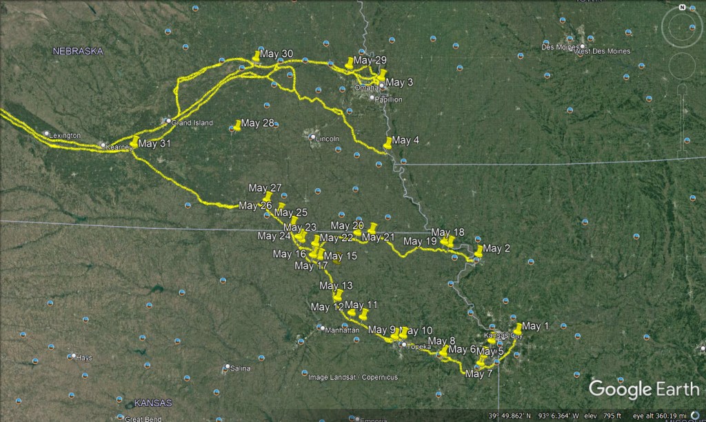
May 1 – A 5-month virtual road trip along the California Trail
Independence, Missouri was a popular launching point for travelers on the California Trail. For this virtual road trip, a good place to start is the National Frontier Trails Museum (https://www.ci.independence.mo.us/NFTM), also home to the Oregon-California Trails Association (https://octa-trails.org/). GPS coordinates are -94.419, 39.087 and the photo is from the NFTM Facebook page.
Chester Ingersoll (https://babel.hathitrust.org/cgi/pt?id=uc1.32106017226140) wrote, in 1847, that “Independence is situated about 3 miles from the river; it is a business place of about 1000 inhabitants. All necessary supplies for the trip, can be had at this place, as cheap as any other, except wagons, which are not so good and durable – they are of the Ohio form, poorly ironed, heavy wooded, and cost from $90 to $100 each. The emigrant should have his wagon made for the trip on the wide track, the box at least 22 or 24 inches high, and 11 feet long, and not put on the covering until he arrives at his point of destination or rendezvous, as he can get it done here better for the trip and as cheap as at home – many are not suitable for the journey, besides they get badly torn on the Missouri Bottoms. Take your wagons from Northern Illinois, but your cattle you can buy at your own state or in this vicinity. Cattle are worth here from $30 to $60 per yoke, cows from $12 to $16 a head. Provisions, such as flour, bread and bacon, are cheaper here than in St. Louis. Pilot bread is $3.50 per hundred, the best flour is $2.12, Bacon, the hog round, $5, clear side of the best $6 per hundred. Coffee, sugar, tea, and all other articles will not pay the trouble of stopping to purchase in St. Louis. All of your flour, bread, rice, sugar, &c., must be put in sacks, as nothing can be carried in barrels and the emigrant had better prepare his own at home of the best materials, to hold about two or two and a half bushels, as they will pack the best, and have to be often handled. There is one thing more, I find that all the emigrants try to carry too much—all have to make their load as light as possible in order to carry their provisions. Since my arrival here, I found many things too worthless to carry, and have thrown them away or left them.”

May 2 – A 5-month virtual road trip along the California Trail
St. Joseph, Missouri was another popular “Jumping Off” town. In an attempt to lure emigrants to their town, the newspapers in St. Joseph and Independence began promoting the services offered in their towns. They also advertised the benefits of the trail leaving their town to join the California Trail. As the rivalry between St. Joseph and Independence grew, the advertising campaigns became more aggressive. The St. Joseph Gazette relied on printing praise from the well-known travelers who had used their route heading east and west. They wrote that people like General Stephen W. Kearney, escorting John C. Fremont to his court martial in 1847, and Moses “Black” Harris, the famous mountain man and trail guide of 1844 had each utilized the facilities in St. Joseph on their overland journeys. Independence had joined in the name-dropping game as well citing people who had traveled with John C. Fremont in 1843. The St. Joseph paper proclaimed that starting from their town meant avoiding the dangerous crossings of the Kansas River on the Independence route. The Independence Expositor claimed that the St. Joe road was almost “impassable”, and the Independence road was “plain, level and beautiful”. The Independence paper also tended to highlight cases of cholera and failed river crossings in St. Joseph. Eventually, it became clear that St. Joseph’s aggressive advertising was successful, and they were the more popular jumping off point. Eleazer Stillman Ingalls (https://archive.org/details/journaloftriptoc00ingarich/) wrote in 1850, “St. Joseph is quite a village, and doing a great deal of business at this time. But the way they fleece California emigrants is worth noticing. I should advise all going the overland route to take every thing along with them that they can of small weight, as every little thing costs three or four times as much here as at home. The markets are filled with broken down horses jockeyed up for the occasion, and unbroken mules, which they assure you are handy as sheep. It is the greatest place for gambling, and all other rascality that I was ever in.”
A good place to visit on this virtual California Trail road trip is the Pony Express National Museum (https://www.ponyexpress.org/). Although not directly related to the California Trail, the Pony Express route followed the same route as the California Trail from Saint Joseph to Salt Lake City. The GPS coordinates are -94.849, 39.756 and the photo comes from their Google Maps Streetview.

May 3 – A 5-month virtual road trip along the California Trail
Council Bluffs, Iowa, originally known as Kanesville, became a popular starting point for the Mormon emigration to the Great Salt Lake Valley.
Thomas Turnbull (https://archive.org/details/tturnbullstravel01turn/) wrote in 1852, “10th May – left in the morning & passed through CottsVille before we got to the Bluffs, Corn at the Bluffs 25 cts. pr B— Corn meal at Kainsville lb 60 cts the Bluffs commences before you get to Kainsville. Cottsville is about a mile long small log House Shingled & covered with mud, Kainsville such a rush of waggons & Horses, Cattle, & Mules, no one never saw in no fare [fair] in the Old country we stopt all night at Kainsville. 9 and camp’ d among the Bluffs. K — stands in a hollow surrounded by Bluffs, small round hills and pulleys for miles camp’ d here on Monday night [also.] 11th May – Boots, shoes, & clothing about the same as they are in Chicago, Corn 25 cts. pr lb. oats 30 cts Bacon 12 ½ cts. Sales at Auction every hour in the day Flour, $16 pr Barrel on Acct of the Emigration $3.50 their is some of the greatest scoundrels I ever saw here.”
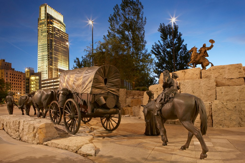
An impressive larger-than-life art display featuring a wagon train and regional wildlife can be viewed in the Pioneer Courage Park in Omaha, Nebraska, just across the Missouri River from Council Bluffs. The GPS coordinates are -95.935,41.261. The photo is from the Pioneer Courage Park website (https://www.firstnationalcampus.com/fnc/html/en/sculpture_park/pioneer.html).
May 4 – A 5-month virtual road trip along the California Trail
Nebraska City lies about 40 miles south of Council Bluffs and spawned another Jumping Off point along what became known as the Oxbow Cutoff. You can visit the Old Freighters Museum (https://www.nebraskacitymuseums.org/old-freighters-museum GPS coordinates -95.863, 40.680). Housed in the home office of the Russell, Majors, & Waddell Freighting Company, this museum’s mission is focused on interpreting the significance of the freighting and shipping industry in the development of Nebraska City. Russell, Majors, & Waddell, more widely known for their later business venture the Pony Express, spent around $300,000 in 1859 to turn Nebraska City into a shipping port for their company. The exhibits in this museum demonstrate not only the history of the shipping firm, but also the history of westward movement along the Oregon, California, and Mormon Trails. James Pressley Yager’s journal (Spring 1970 to Summer 1971 of the Nevada Historical Society Quarterly http://epubs.nsla.nv.gov/statepubs/epubs/210777-index.html) started his journey to California in Nebraska City in 1863. He didn’t write much about this town but he spent two weeks there preparing for the trip – “Wednesday April 29 – After two days on the Missouri River laying up every night, we arrived at Nebraska City Nebraska Teritory ten oclock this morning. Finding conveyance for our bagage we walked up to the Cincinnati House kept by Mr. Hamlin. On the wharf is calle Karney City on the hill is the main town called Nebraska City. St Joe to N. City 178 miles. Friday May 14th – Two hours before sun set we left Nebraska City going three miles & camped. Many other wagons were camped near by.” The photo is from the Old Freighters Museum website.

May 5 – A 5-month virtual road trip along the California Trail
For about the next two weeks we’ll be following (virtually) the road out of Independence across northeastern Kansas. Pioneer Crossing Park in Shawnee, Kansas (GPS coordinates -94.707, 39.0144, photo from Google Maps Streetview) has some nice sculptures and interpretive panels about Trail history. Here, only a dozen or so miles on the Trail, emigrants were already beginning to get a taste of what their life on the Trail might entail. Hugh Morgan Price (https://www.octa-journals.org/cave-springs-collection/diary-of-a-forty-niner-hugh-morgan-price-1849), on April 27, 1849 wrote, “Moved out to Mr. Rice’s 8 miles from Independence. Here Capt. McCaddon of the Zanesville Company died with the cholera. In laying in our provisions we determined to lay in nothing but the real substantials of life. Our provisions consisted of 600 lbs. flour, 440 lbs. bacon, 227 lbs. crackers, 25 lbs. rice, 20 lbs. sugar, 18 lbs. coffee, 1 lb. sassafras tea, 85 lbs. salt for selves and mules.”

May 6 – A 5-month virtual road trip along the California Trail
The Mahaffie Farm (https://www.mahaffie.org/, GPS coordinates -94.8, 38.892) is a living history museum that tells the story of the Mahaffie family. According to their website, the Mahaffie’s arrived in Olathe in 1857 from Logansport, Indiana. James B. and Lucinda Mahaffie purchased the farm site you can visit today. The Mahaffie farm was one of the most prosperous in Johnson County in the 1860s and early 1870s. It is located on the “Westport Route” of the Santa Fe Trail, which also carried travelers leaving Westport, Missouri and crossing what is now the Kansas City metro region for the Oregon and California Trails as well as the Santa Fe Trail. The photo is from Google Maps Streetview.
In his book An Overland Journey, from New York to San Francisco in the summer of 1859 (page 28) (https://quod.lib.umich.edu/m/moa/afk4378.0001.001/28?page=root;rgn=full+text;size=100;view=image), Horace Greeley described passing through this area: “Passing Shawnee [the site of yesterday’s virtual tour location], a prairie village of twenty or thirty houses, with a large hotel, our road bore more directly south, and soon brought us in sight of the great Santa Fé trail, with its white-topped emigrant wagons, and three great contract trains, one of them still in corral, the others with six pair of mules to each wagon, attempting it, for the most part, in vain. The mules were small, and new to work – to this work, at all events – and drew badly; while the wheels cut so deeply into the yielding paste beneath them that little or no advance was made. I presume they all corraled for the night within two miles of the places where we saw them. Crossing the trail almost at right angles, we left the small village of Olathe (county seat of Jackson county) a mile or so to the west, and struck off nearly due south, over high prairies sloped as gently and grassed as richly as could be desired, with timber visible along the watercourses on either hand. Yet there was little to no settlement below Olathe [the site of Mahaffie’s Farm] …”

May 7 – A 5-month virtual road trip along the California Trail
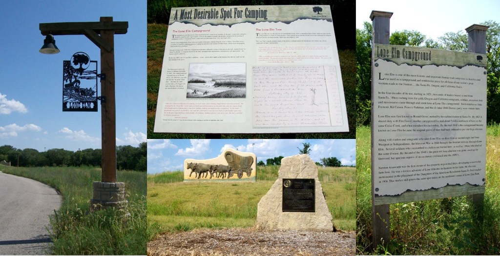
Elm Grove Campground was frequented by travelers on the Santa Fe, Oregon, and California Trails. However, what had been a substantial grove of elm trees in the 1820s was represented in the 1840s by a lone elm tree because of the use of the other trees for firewood by the campers. The lone elm itself was cut down in 1849. The composite photos of the various sculptures and interpretive markers found in the park were downloaded from the Historic Marker Database (https://www.hmdb.org/m.asp?m=34342 GPS coordinates -94.830,38.822).
Dr. Frederick A. Wislizenus in his book Memoir of a Tour to Nothern Mexico (https://www.google.com/books/edition/Memoir_of_a_Tour_to_Northern_Mexico/Kh9_wDQBXlYC?hl=en&gbpv=1) wrote on May 23, 1849: “We started in the morning for ‘Lone Elm-Tree,’ or ‘Round Grove’ (10 miles.) The prairie over which we travelled looked more beautiful than I had ever seen it…. The road was excellent. This long trail through the prairie, the Santa Fe road, made only by thousands of large wagons that have travelled over it, is really a better road than is met with in a great part of Missouri and Illinois. The higher elevation of the prairie, with a most gradual ascent and descent, and the facility of leading the road over the most favorable ground, explains it sufficiently. At ‘Lone Elm-tree’ we halted at noon: rather a poor camping place, with bad water, scanty grass, and a single elm-tree; some brushes growing along the water. How long the venerable elm-tree, that must have seen many ages, will yet be respected by the traveller, I am unable to say; but I fear that its days are numbered, and that the little valley will look more desolate than ever.”

So interesting!
LikeLiked by 1 person