September 15
This day in Trail history – A composite journey along the California Trail – September 15, 1849
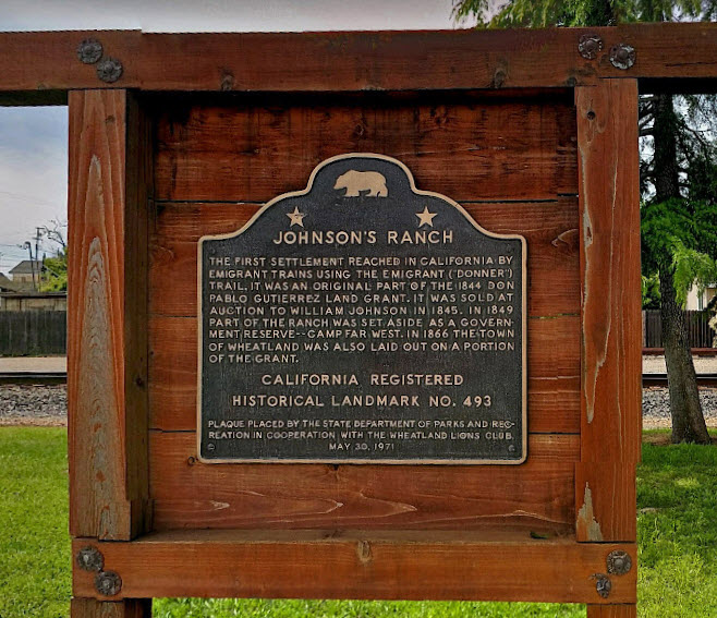
“We reached Johnson’s ranch just before night. It is an old establishment, constructed partly of logs and adobes and has been a famous cattle ranch for many years. It is now converted into a store and house of entertatinment, and being at the junction of many trails leading to Sutter’s, presents a busy appearance. There were a large number of emigrants, prospectors and greasers hanging about the premises. While the doctor and I were looking about and interviewing the motley crowd, such was our forlorn and dilapidated appearance that a simple-hearted fellow innocently asked the doctor if he was a white man, having doubts about his race. A fiery sun and lack of water materially affects the color line. After a brief halt we moved on two miles to the ford of Bear River, there a stream about fifty yards wide, where we encamped for the night. Distance, twenty miles.” – Ansel J. McCall. Ansel’s book can be viewed at https://babel.hathitrust.org/cgi/pt?id=uc1.31158005904320&view=1up&seq=100&skin=2021. This historical marker is located in Wheatland, CA. The photo was captured in Google Maps at https://www.google.com/maps/@39.0103164,-121.4232762,3a,75y,332.63h,90t/data=!3m8!1e1!3m6!1sAF1QipPyvYma3rPZdktE2pfiJcwwCBtcxqqRn44RSwkD!2e10!3e11!6shttps:%2F%2Flh5.googleusercontent.com%2Fp%2FAF1QipPyvYma3rPZdktE2pfiJcwwCBtcxqqRn44RSwkD%3Dw203-h100-k-no-pi-0-ya139.08702-ro-0-fo100!7i10240!8i5120.
September 16
This day in Trail history – A composite journey along the California Trail – September 16, 1859
“Found the road exceedingly rough for some miles as we continued our course down the mountain, but it gradually improved as we traveled on. On these heights we find a moderate growth of pine and some cedar, which are becoming larger and larger as we go down on this long mountain slope. We have just passed a beautiful pair of little lakes, called “Twin Lakes”, surrounding which there is a beautiful mountain country with a splendid growth of timber on it, some of the tallest of which are the famous red woods, which attain such a gigantic bulk on this slope of the Sierra. Our descent towards the valley is now very sensibly shown by the rising of the Grand Ridge of the Sierra, behind us, whose top glitters with large fields of snow, over which we have just passed. Yet looking forward we see no apparent end to the descent before use, and we can only see it with the eye of faith. This evening we passed what is called Tragedy Springs, a noted place on this road as it was the scene of a horrid Indian massacre in 1848 of some emigrants who were encamped here, all of whom were murdered and burnt in their camp, of which there is some memorial in a writing on a tree, and a pile of stones marking the place of interment of what fragments were found of their remains….” – Thomas Cramer. Cramer’s diary can be downloaded from the OCTA collection at https://www.octa-journals.org/merrill-mattes-collection/journal-containing-incidents-of-travel-across-the-plains-from-kansas-to-california-thomas-cramer-1859. The photo of a marker carved on a tree at the site of Tragedy Springs was downloaded from the Library of Congress at https://www.loc.gov/resource/hhh.ca0161.photos.

September 17
This day in Trail history – A composite journey along the California Trail – September 17, 1850
“About 1 Oclock P. M. started on the Desert which commences at the crossing of the Outlet and continues to the Carson River, the distance is said to be 40 miles. We Traveled all night and in the Morning at sunrise found ourselves ahout 6 miles from Carson River. Our Teams very tired and the worst part of the Desert before us. We held a consultation and concluded to take the Cattle from the Wagons and send them forward with a part of the company to the river while some of us should remain with the Wagons. This was accordingly done. Four of us remained in the Desert till ahout sundown when those who had gone ahead in the Morning returned with the Teams and we all went on to the River. Here we found quite a village of Tents a number of Traders having established themselves here temporarily for the purpose of trading with the Emigrants. They were selling Flour at 20 cents per pound which we considered cheap having paid one Dollar a pound at the Big-Meadows. The Destruction of property on the Desert during the present season has been immense. At the time we crossed it was estimated that 5 thousand head of Horses, Mules and Oxen were lying dead in a distance of 40 miles; incredible as this statement may seem it perhaps falls short of the actual number. The destruction of Wagons and otber property was in proportion. Our company lost 2 Horses and an other company who Traveled with us lost 32 head of Oxen. It is supposed that the Cattle generally died from the effects of the Alkali water at the crossing of the outlet. The Carson river is about 30 yards wide much the same size as the Humboldt, it runs Into a Lake and sinks, the water is clear and apparently free from Alkali.” – William Edmundson. Edmundson’s diary was printed in 1908, Volume 8, No. 7 of the Annals of Iowa and can be downloaded from https://ir.uiowa.edu/annals-of-iowa/vol8/iss7/5/. The painting is from the Forty-Mile Desert Interpretive Sign in the outdoor plaza of the California Trail Interpretive Center.

September 18
This day in Trail history – A composite journey along the California Trail – September 18, 1852
“Early today we sold our wagon for $10.00 while still sleeping in it. Pfeiffer’s wagon will remain here. At 9 o’clock we sold the oxen, practically all of them being sick from poison herbage eaten the day before. We got $55 for them, per yoke. Now we are freed of our wagons and cattle. We proceed to divide. The articles are auctioned. Biebrich and Herbst are auctioneers. Certain articles that we could not divide, and which cost $15, and were sold for $31. The whole proceeding was very laughable. Each packed his things in a given spot, and he who had the least was really better off, because he had less to carry. (under tall pines.)” – Charles G. Schneider. Charles’ diary is part of the OCTA collection and can be downloaded at https://www.octa-journals.org/merrill-mattes-collection/charles-g-schneider-1852. Charles was near Downieville, CA when he wrote this entry. In 1852 Downieville was made the local county seat. The photo is from 1860 and was downloaded from https://westernmininghistory.com/towns/california/downieville/.

September 19
This day in Trail history – A composite journey along the California Trail – September 19, 1849
“Our course is still over the California range of Sierras. The first five miles, to-day, were rough and rocky, and brought us down to a brook of clear water. The next twelve miles, to water, took us over high mountains, with a quarter of a mile descent down a steep mountain-side. To the right of this, in a ravine, we found a small spring of water. The road for the next nine miles, to water, came over a succession of high mountains, through oak timber, upon which our mules browse. The descent is so difficult that teamsters must take their cattle out, and let the wagons down by hand. Camped, in our blankets, among the rocks. Distance, twenty-six miles.” – Joseph Sedgley. Joseph’s account of his travels can be viewed at https://babel.hathitrust.org/cgi/pt?id=njp.32101074863992&view=1up&seq=64&skin=2021. A copy of the Harold von Schmidt painting is displayed in the California Trail Interpretive Center. This version was downloaded from https://www.quora.com/When-people-were-going-west-in-wagon-trains-in-the-nineteenth-century-how-did-they-get-the-horses-and-wagons-over-the-Rocky-mountains.

September 20
This day in Trail history – A composite journey along the California Trail – September 20, 1865
“It is eleven miles from here to Cape Horn. From Cape Horn to Simpsons Park is ten miles. (Stage Road) No feed, no water. But here is a cut-off across mountain. Sixteen miles across to Simpsons Park. Took grass and water on this road. Very rough road. We took the cut-off this morning, drove two miles for breakfast at springs. We concluded to stop here today to wash and rest our team. Two miles today.” – James McNabb Colwell. Colwell’s diary was published in four parts in Tales and Trails by the Columbia Gorge Genealogical Society. This newletter containing this entry can be downloaded at http://community.gorge.net/genealogy/newsletter/v26n2.pdf. James has passed over Donner Pass and is following Bear River at this point. The photo by Brigitte Williams is from Google Earth (https://lh5.googleusercontent.com/p/AF1QipMpIebkfmwGWl4q2fwro0_24IlHSOiG1zn78tYS=h1440) probably near where Colwell was stopped on this date.
September 21
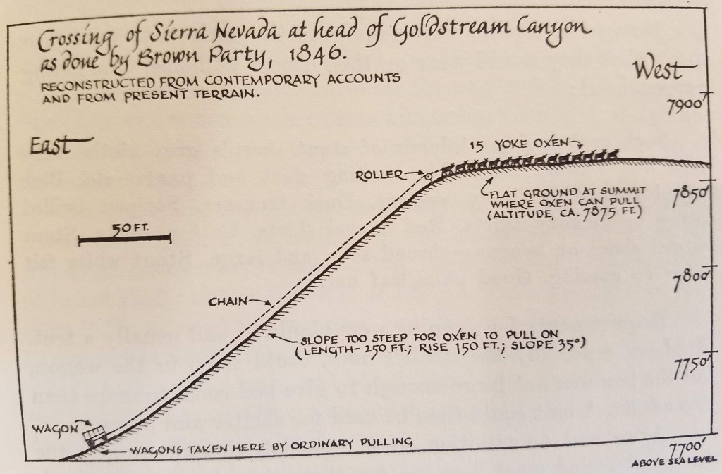
This day in Trail history – A composite journey along the California Trail – September 21, 1849
“Here we doubled & threbled teams to get up the hill took us all day and it was as hard a days walk as we had in the whole seige Our cattle got so tired out at last that all that 14 yoke could do was to haul up an empty waggon This was a hard time on both men and cattle For here both man and brute has gest barely enough to eat to keep alive and enough to give strength We lived on cracers and coffe the cattle on got scarcely anything” – Elijah Bryan Farnham. Farnham’s diary was published in the Indiana Magazine of History and can be viewed and downloaded at https://scholarworks.iu.edu/journals/index.php/imh/article/view/8010/9734. The illustration of using multiple ox teams to pull wagons up steep hills is by George R. Stewart in his book The California Trail.