August 15
This day in Trail history – A composite journey along the California Trail – August 15, 1849
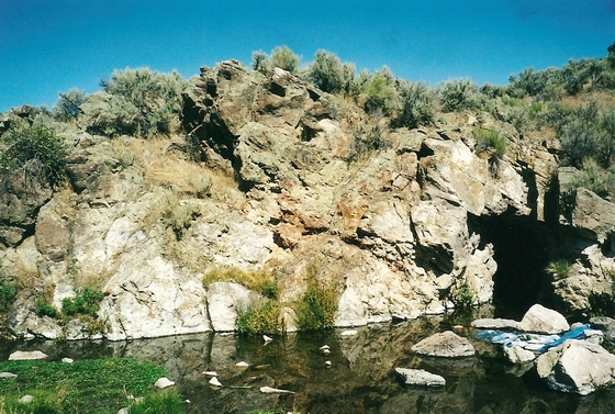
“Our road leads south, along the foot of the mountain, at the top of which is snow, and where we found a lot of warm springs, that are great curiosities. These springs are of different sizes and shapes; some are round like a kettle; others are square. The heat from this water ranges from blood to boiling heat – one of them thirty yards square, the water of which boils all the time; we called it the boiling lake. Grass grows close to the edge of these springs and the water in them is very clear, some of them being from twenty to thirty feet deep. Taking this valley altogether, it is the finest we have seen in this great basin, and far exceeds the Salt Lake Valley; plenty of water and grass and some timber. After traveling twenty miles, we again encamped at the foot of this mountain, near a large gap.” – Anonymous. At this point the group is traveling south along the eastern edge of the Ruby Mountains on the Hastings Cutoff. The writer of this diary is unknown, but it is identified with a group of emigrants referenced in the diary as the “Fayette County Boys” and can be downloaded from the OCTA collection at https://www.octa-journals.org/merrill-mattes-collection/feyette-county-boys-enroute-to-california. The photo depicts Ruby Valley looking southeast from the base of the Ruby Mountains. It was taken by Ralph Maughan and was downloaded from https://lh5.googleusercontent.com/p/AF1QipMmYXQlrI2zc4wVthhu0TH0Ez7yR3N7XOTF2g28=h1440.
August 16
This day in Trail history – A composite journey along the California Trail – August 16, 1850
“We lay up to-day to jerk our beef – something new in the history of our lives. Before it was light we were out, collecting willows to make our fires. The beef was shot and dressed and the meat cut into thin slices and placed upon a scaffold over a fire. While this was being done two or three were looking after the mules and discovered that one was missing. A large pack train had started off very early and we thought perhaps it might have followed them off. J. W. W[ilson] & W. L. R.[obards] were dispatched after them, with instructions to go on till they found it—we were having pretty good reasons to believe that some one had it. — During the day a goodly number of the sweet little chub was caught and a report reached us that four horses were stolen…” – Madison Berryman Moorman. Madison’s diary can be viewed at https://babel.hathitrust.org/cgi/pt?id=uc1.32106000651817&view=1up&seq=88. The photo is from a YouTube video about how to make beef jerky located at https://www.youtube.com/watch?v=RbKhbS5GcAg.

August 17
This day in Trail history – A composite journey along the California Trail – August 17, 1849
“I wished to take the company by the Fort Hall route, not knowing of any other, on this course, till about 10 days ago; and finding that Hedgespeth, a mountaineer, had discovered a passage into the Great Basin, through the N.E. corner of the boundary mountains, and that a large number of trains had preceded us on it, and from reliable information, that it was a good road, and much shorter & better than by the way of Fort Hall, and my men were in favor of it, I called a meeting at 2 P.M. and submitted it to them. They unanimously resolved to take it. It is known as ‘The Emigrant’s Cut-off.’ Night damp and cold.” – J. Goldsborough Bruff. Bruff kept copious notes on his journeys across the west. This 1849 handwritten account can be viewed at https://collections.library.yale.edu/catalog/2112234.

August 18
This day in Trail history – A composite journey along the California Trail – August 18, 1849
“Still continued our route down the valley There was not a cloud except it is of dust to be seen The valley was here full 15 miles wide We have had Sand road it was easy to the Cattles feet but hard to get over We had sand hills to go over that took hard pulling We crossed the river to the left hand side of it One of our men G.G. in shooting gun that had been loaded for some time had it busst in his hands The members of our Company have been exempt untile this from any acidents arising from from the discharge of fire arms Yet from the carlessness with which guns have been handled the escape from such acidents has been more from good luck than from than from the risk of those that shoot” – Elijah Bryan Farnham. Farnham’s diary was published in the Indiana Magazine of History, vol. 46, no. 3 (1950) and can be viewed at https://scholarworks.iu.edu/journals/index.php/imh/article/view/8010. Sand hills such as described by Farnham can be seen in the region near Winnemucca, NV.

August 19
This day in Trail history – A composite journey along the California Trail – August 19, 1850
“This morning, after refreshment was over, we collected and started to see what came next, and in traveling fifteen miles down this stream [South Fork of the Humboldt River on the Hastings Cutoff], we crossed it about twenty-five times, some places having to wade along in it crotch deep, for a half mile, there being no room on the banks for a road, and in many places, these crossings were bad beyond comparison. No timber along here scarcely, and the country away from the streams is perfectly barren and desolate looking. In going down this kanyon to-day, we had a hard time getting our little cart along. This day’s travel brought us to the Fort Hall road, and we now find that we missed it by taking the cut-off or Hasting’s route by at least one hundred and fifty miles. This road was not traveled by so many as the Fort Hall road. Here the Indians have been commiting some depredations; all are on the watch for them to take their lives. This morning we packed as much of our deceased bullock on his surviving comrades as we conveniently could, and this evening we find ourselves at the fork of the Humbolt, with our digestive organs perfectly dormant for the want of something to do. Oh dear! ‘must we always live at this poor dying rate?'” – John Wood. Wood’s diary can be viewed at https://archive.org/details/GR_4732/page/n55/mode/2up. The picture is from the South Fork State Recreation Area Wayside Exhibit next to the Ranger Station. The information from the wayside can be found in the California Trail Center app, available for free on the Apple and Google app stores. The online version is located at https://ctic.oncell.com/en/south-fork-state-recreation-area-288680.html.

August 20
This day in Trail history – A composite journey along the California Trail – August 20, 1849
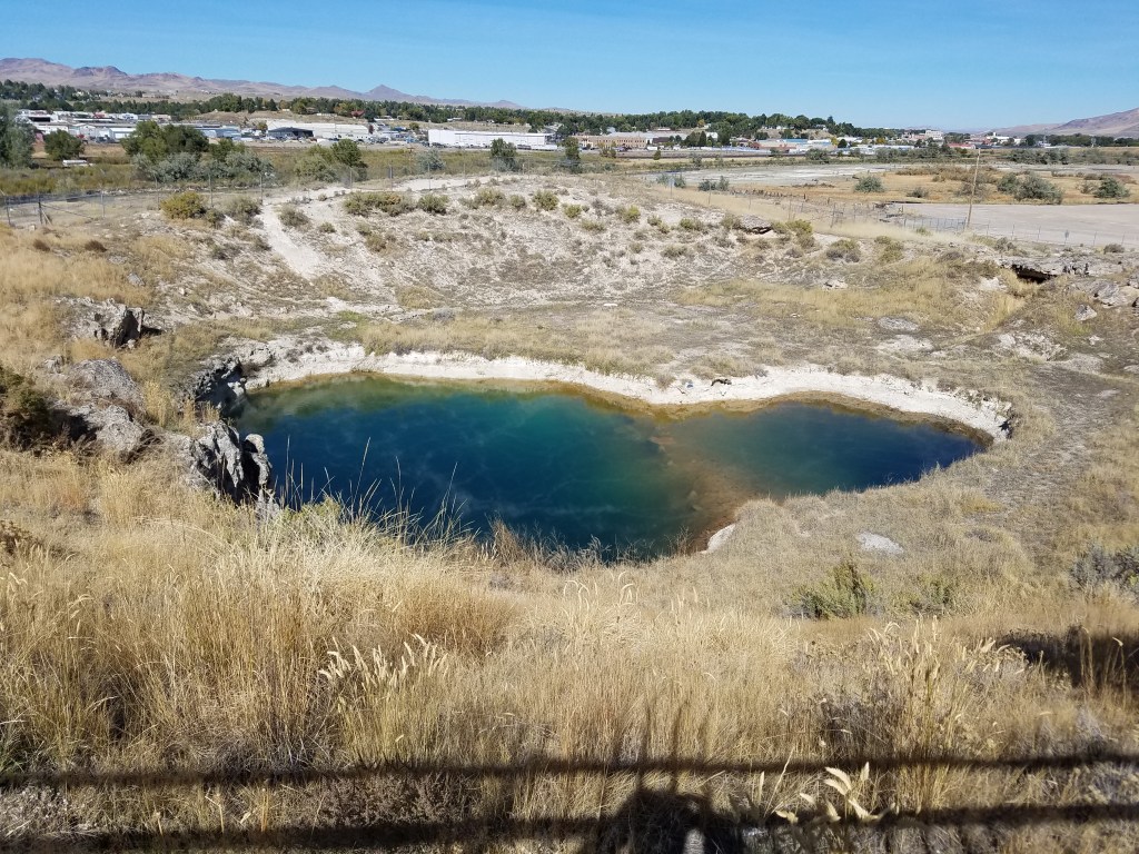
“About five miles from our last night’s camp we reached the “Hot Springs”. They are situate on the left side of the River as we descend it on its immediate Bank – there are perhaps a dozen of these, in the immediate vicinity large quantities of Saline effervescence perhaps comingled with sulphur (as I think from the smell & appearances,) to the depth of several feet has been thrown off from the [?] of the springs as they gush from the hillside send up a vapor which from its heat as I stood over the spring was difficult to respire, the temperature was certainly near if not quite at the boiling point. I consider these the greatest curiosity which I have yet seen. We were told by some emigrants who were at the springs that there was a large lake immediately over the Bluffs the waters of which were equally as hot – but as my companions & messmates had no curiosity to see it I felt loath to go alone & get behind my train. These springs probably run directly from this lake if the report be as it is stated.” – Amos Steck. Steck’s diary is part of the OCTA collection and can be downloaded at https://www.octa-journals.org/merrill-mattes-collection/diary-of-amos-steck-1849. The photograph is of the “Hot Hole” in Elko, NV.
August 21
This day in Trail history – A composite journey along the California Trail – August 21, 1857
“Three miles from camp the road leaves Goose Creek and goes into a canon that is four miles long. A little stream follows the canon for two or three miles, this is the last water for 13 miles. The first part of the drive was most dreadfully stony but the latter part was excellent. Billy got his ‘fiddle’ out and sawed for a while. Rock Springs was the next watering place: no grass. The springs are situated at the head of 1000 springs valley, which has little vegetation except sage brush. Two miles down the valley camped without grass or water. Raining.” – Helen Carpenter. Helen’s diary is part of the OCTA collection and can be downloaded at https://www.octa-journals.org/merrill-mattes-collection/a-trip-across-the-plains-in-an-ox-wagon-helen-carpenter-1857. The photo of Rock Springs was downloaded from the Trails West website at https://emigranttrailswest.org/virtual-tour/california-trail/.