I forgot to schedule the August posts here, so I’m playing catchup. Here are the first week’s worth of social media posts that I did for the California Trail Interpretive Center. The rest will follow at their scheduled times.
August 1
During the month of August we’ll present diary excerpts from a “virtual journey” along the California Trail. The portion of trail covered during this hypothetical August journey is shown in the Google Earth image, ranging from Salt Lake City, Utah or just west of Soda Springs, Idaho to just west of Winnemucca, Nevada. We’ve been using online sources so you can easily see the references and will have to start re-using some of these sources to complete the August and September parts of this virtual journey.

This day in Trail history – A composite journey along the California Trail – August 1, 1849
“The thought that another month would end our journeying, together with the rest which we had enjoyed, put us in good spirits this morning as we started off and we made a good forenoon drive.
As we were leaving our noon halt, we were agreeably surprised at seeing an old Ottawa acquaintance in the person of Charles Fisher, who rode up on horseback…. By him we learned … of the abandonment by his companions, of Joseph E. Ware, formerly from Galena, but known in St. Louis as a writer, and if I recollect right, the publisher of a map and guide-book to California. He was taken sick east of Fort Laramie, and his company, instead of affording him that protection which they were now more than ever bound to do, by the ties of common humanity, barbarously laid him by the road side, without water, provisions, covering or medicines, to die! Suffering with thirst, he contrived to crawl off the road about a mile, to a pond, where he lay two days, exposed to a burning sun by day and cold winds by night, when Providence directed Fisher and his mess to the same pond, where they found him. With a humanity which did them honor, they took him to their tent and nursed him two days; but nature, over- powered by exposure as well as disease, gave way, and he sank under his sufferings. He told Fisher who he was, and related the story of his company’s heartlessness. He was a young man of decided talents. Fisher was confident that if he had had medicines and proper attendance he might have recovered. What misery has not California brought on individuals?” – Alonzo Delano. Alonzo’s diary can be viewed at https://archive.org/details/lifeonplainsamon01dela/page/162/mode/2up. The illustration is from a page in Delano’s book.

August 2
This day in Trail history – A composite journey along the California Trail – August 2, 1849
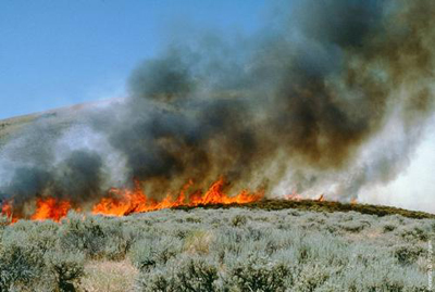
“Travelled twelve miles, crossing a deep creek; a handsome and rapid little stream, and encamped early by a smaller stream affording good water and plenty of pasture along its banks. The wild sage again becomes very plenty here, and furnishes abundance of fuel. This artemesia or wild sage, with all vegetation except along the water courses, has become dried up for the want of rain, and great care is necessary to prevent camp fires from breaking out and running over the whole country. Extensive districts are burnt over, along the road already; and it is feared by some that the little pasture remaining from the drouth, may be so destroyed with the burning of the grass, that it will be difficult to find forage enough for the teams on the road, involving the entire route yet to be traversed.” – Samuel Rutherford Dundass. Samuel’s diary can be viewed at https://archive.org/details/journalofsamuelr00dund/page/44/mode/2up. The fire picture was downloaded from https://www.fs.fed.us/database/feis/fire_regimes/mountain_big_sagebrush/all.html.
August 3
This day in Trail history – A composite journey along the California Trail – August 3, 1849
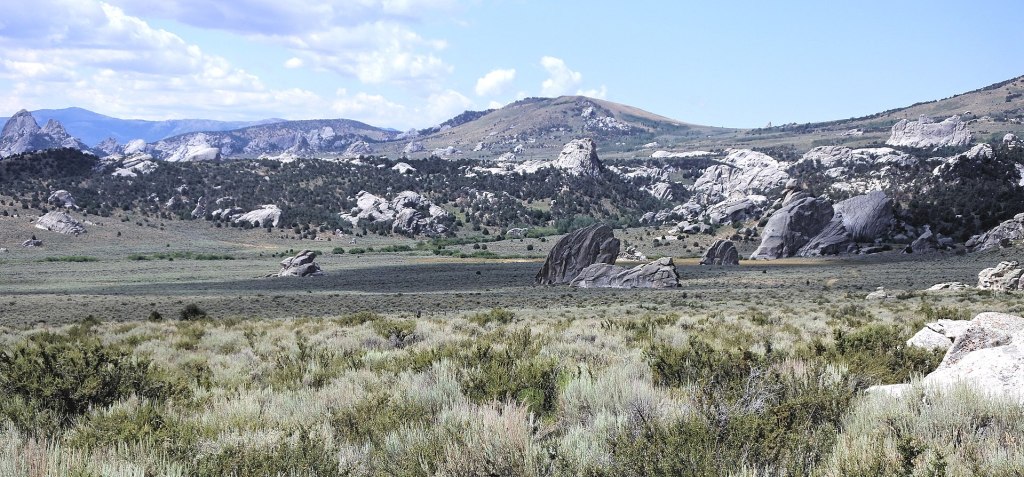
” Morning cool. We crossed the dividing ridge separating the waters of the Pacific from Salt Lake. Five miles brought us to a creek of good water. The road here opens into a valley, eight miles wide, which is swampy in places, and contains good water; thence, the road passes around a mountain and descends into a valley, in which we camped, one mile from the mountain, in an open space [City of Rocks], near some large, rugged rocks of various forms, called Steeple Rocks. They were covered with dwarf cedars. We passed between some of these rocks, one of which is two hundred feet high. Another, jutting out thirty feet, is called Portico Rock. Here, the Mormon trail [Hensley / Salt Lake Cutoff] comes into ours. Passed over hills and came to a plain, five miles wide, which we crossed, and camped at seven. Distance, thirty miles. Passed one grave.” – Joseph Sedgley. Sedgley’s diary can be viewed at https://babel.hathitrust.org/cgi/pt?id=njp.32101074863992&view=1up&seq=50. The photo of the City of Rocks was downloaded from https://en.wikipedia.org/wiki/City_of_Rocks_National_Reserve#/media/File:City_of_Rocks_view_072617.jpg.
August 4
This day in Trail history – A composite journey along the California Trail – August 4, 1859
“This morning crossed Bear River at the Ferry, which is about twelve miles from where it empties into the [Great Salt] Lake. It is here a deep and sluggish stream. After crossing we started for a spring nine miles off. In three miles crossed a deep and narrow creek called the Molad, originally no doubt ‘Mal Eau’, as its waters are too bad for man or beast. We rendesvoued at the Spring, and found that we had twenty-seven wagons and about fifty men able to bear arms…. The most deadly prejudice exists in the gentile mind against the Mormons, and it would be an easy matter to recruit a force here to Rub them out…. We remained at the Spring all night as it was too far to the next drink. We have a long and weary drive before us tomorrow.” – Thomas Cramer. Cramer’s diary is part of the OCTA collection and can be downloaded at https://www.octa-journals.org/merrill-mattes-collection/journal-containing-incidents-of-travel-across-the-plains-from-kansas-to-california-thomas-cramer-1859. A historical marker discussing the ferry across Bear River is located at N 41° 44.316 W 112° 05.922 and the image of the marker was downloaded from https://www.waymarking.com/waymarks/wm7W8A_The_Bear_River_Crossing.

August 5
This day in Trail history – A composite journey along the California Trail – August 5, 1850
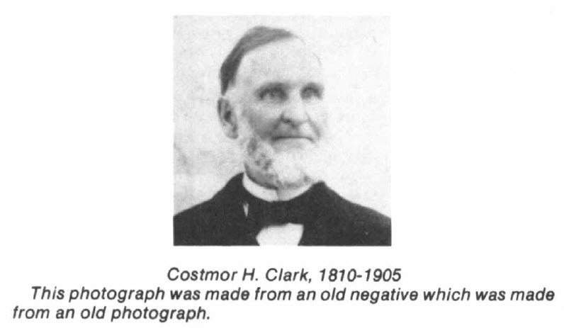
” At 7 A.M. resumed our journey—travelling all day a little West of South along the base of the mountains from which flow at short intervals small streams of clear cold snow water into an extensive valley covered with abundance of grass and wild clover which our animals eat with great avidity—We are undoubtedly travelling too much South—but expect soon to find the road to make a turn through the mountains. We have just supped upon “Penola” and water and are ready to give ourselves up to ‘morpeus’ & dreams.” – Costmor H. Clark. Costmor’s diary was published in Rangelands, vol. 8, no. 4 (1986) and can be downloaded at https://repository.arizona.edu/handle/10150/640818.
August 6
This day in Trail history – A composite journey along the California Trail – August 6, 1850
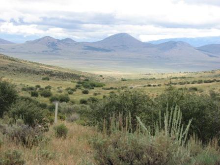
“This morning we left a small creek, the waters of Lewis River, and went over a ridge of moderate elevation easy of ascent and descent and took our nooning on a pretty branch that runs into Salt Lake, here is small portions of land susceptible of cultivation, there are a few scrubby Cedars from 6 to 10 feet high on the mountain sides and small parcels of snow This afternoon we have been among Rocky Mountains worthy of the name indeed, Stupendous Magnificent and Sublime! our road is good, seeming to wind its way through Merracalously and we have traveled about 23 miles” – A. W. Harlan. Harlan’s diary was published in the Annals of Iowa, v. 11, no. 1 (1913) and can be viewed at https://archive.org/details/overlanddiarieso00deanrich/page/32/mode/2up. This reference also contains several other emigrant diaries from the 1850s. Harlan’s description of the Rocky Mountains was made in the vicinity of Granite Pass, the photo of which can be viewed on the web page of the Idaho Chapter of OCTA at https://octa-trails.org/regional-chapters/idaho-chapter/.
August 7
This day in Trail history – A composite journey along the California Trail – August 7, 1850
“Leaving the creek, our ascent was gradual to the top of a mountain nine miles distant. Descending this ridge half a mile from the summit is an excellent spring, a little to the left of the road. A little below this, where the water leaps down a rock six or eight feet, some traveler before us had amused himself in arranging a small water wheel, which was in active operation as we passed. A mile further on at the foot of the ridge, is a small creek. We had the misfortune to lose one of our oxen here. It dropped dead in the yoke, twenty yards from the creek. Half a mile from here is another small creek, where we encamped. Both these streams run to the south and no doubt empty into the one we left this morning. We met a small company of traders here from Salt Lake and bound for Fort Hall by a blind trail turning to the right. The Salt Lake road enters the Cut-off road fifteen miles ahead. It is thirty miles from this point to Fort Hall and one hundred and fifty to Salt Lake. There was a great number of dead cattle and horses in this small valley, many of them in the creek and we had to go up the stream half a mile to procure water fit for use. For days—yes, I may say for weeks— the road has been strewn with the dead carcasses of these poor animals.” – James Bennett. Bennett’s diary can be viewed at https://babel.hathitrust.org/cgi/pt?id=mdp.39015012997295&view=1up&seq=64. The Google Earth photo by Ralph Maughan was taken in the Fish Creek region of southeastern Idaho and was downloaded from https://lh5.googleusercontent.com/p/AF1QipMhKlDN2Bb55Us8zD_gk4rBp_lAhHsAXaoWQpHI=h1440.

