July 1
During the month of July we’ll present diary excerpts from a “virtual journey” along the California Trail. The portion of trail covered during this hypothetical July journey is shown in the Google Earth image, ranging from Casper, Wyoming to Salt Lake City, Utah or just west of Soda Springs, Idaho. Planned diary entry date locations are shown on the map.

This day in Trail history – A composite journey along the California Trail – July 1, 1849
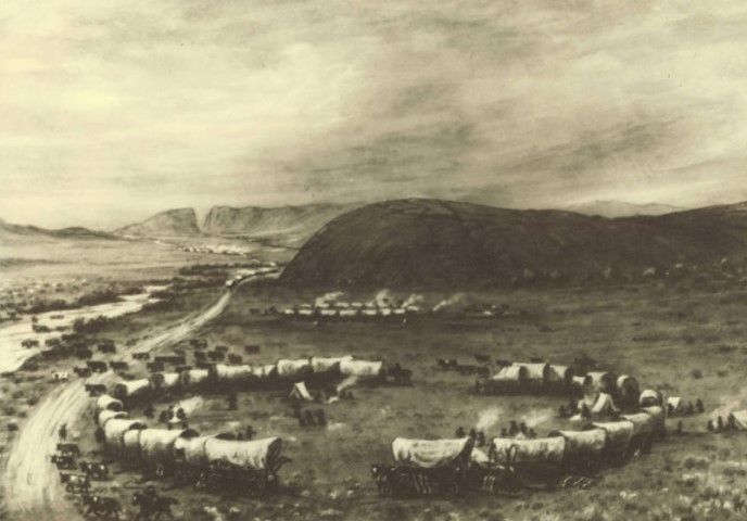
“Left our camp Early and after going about 10 Miles we came to Independance Rock where I placed my name and date with Hundreds of others. This rock is located on the bank of Sweet Water river and … very romantic Scenery. We remained here 3 or 4 hours Grass and good Water in abundance. We had a good Swim in the river … we proceeded about 5 miles when we came to devils Gate this is certainly a great curiocity. It is an opening in a ridge of rocks which is a connecting link of Wind River mountains through which the Sweet Water flows with tremendous velocity I went up the ravine from the East Side and[?] I could go no farther for the foaming dashing water I thought I had better climb up where I thought I could without much trouble continue[?] the attempt and would have been very glad to have crawled[?] if I could. I tried the Experiment on a little but found I could not find foot holds…. After taking a good rest I again commened[sic] Climbing with any thing but pleasant feelings, now and then a fragment of rock would loose and go to the bottom with a hollow sound that would make the cold chills run all over me, now and then I would find a place where I could take a respite[?]. I would think of the great fear I was in the not[?] of accomplishing then I would think of My Carcass on a pile of rocks 3 or 4 Hundred feet lower down. On I went through hope and fear until I reached the top where I sank down Exausted. Several persons on a projecting rock had been watching my progress occasionaly I would bee out of their Sight and Evry noise they herd they Supposed to be me on a downward Excursion. After recovering from my Excitement and fatigue I crawled out upon a projecting rock to look down and from this it looked impossible for any living thing (Save Birds) to climb up this wall … went on to our teams which had halted for the night Some 5 or 6 miles farther on. We had evrything cumfortable here good Grass, Water and fuel I did not reach our camping until late.” – James S. Abell. James’ diary can be downloaded from the OCTA database at https://www.octa-journals.org/merrill-mattes-collection/diary-of-james-s-abell. The painting of Independence Rock and Devil’s Gate (in the background) is by William Henry Jackson and was downloaded from https://contentdm.lib.byu.edu/digital/collection/Jackson/id/3364/.
July 2
This day in Trail history – A composite journey along the California Trail – July 2, 1834
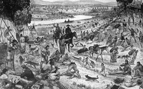
“During our stay at the rendezvous [at Green River], many of us looked anxiously for letters from our families, which we expected by the later caravans, but we were all disappointed. For myself, I have received but one since I left my home, but this has been my solace through many a long and dreary journey. Many a time, while pacing my solitary round as night-guard in the wilderness, have I sat myself down, and stirring up the dying embers of the camp fire, taken the precious little memento from my bosom, undrawn the string of the leathern sack which contained it, and poured over the dear characters, till my eyes would swim with sweet, but sad recollections, then kissing the inanimate paper, return it to its sanctuary, tighten up my pistol belt, shoulder my gun, and with a quivering voice, swelling the ‘all’s well‘ upon the night breeze, resume my slow and noiseless tramp around my sleeping companions.” – John Kirk Townsend. This excerpt is from image 89 (page 195) of Townsend’s Narrative of a Journey across the Rocky Mountains, to the Columbia River. Townsend was part of the pre-Oregon Trail explorers who were laying out the route across the Rocky Mountains to the Oregon Territory. His Narrative can be viewed at the Library of Congress site at https://www.loc.gov/resource/lhbtn.th021_0107_0370/?sp=89. The sketch of a Rocky Mountain Rendezvous was downloaded from https://commons.wikimedia.org/wiki/File:Rocky_Mountain_Rendevouz.jpg.
July 3
This day in Trail history – A composite journey along the California Trail – July 3, 1849
“This was a cold morning and we did not start until late. In two miles we drove through South Pass. It is nothing more in appearance than a small ridge. We drove to the Pacific Spring and encamped for the night.” – Israel Hale. Hale’s diary is available in the OCTA collection and can be downloaded at https://www.octa-journals.org/merrill-mattes-collection/diary-of-trip-to-california-israel-f-hale-1849. The photograph of the roadside interpretive marker at Pacific Springs was downloaded from https://www.hmdb.org/m.asp?m=96660.

July 4
This day in Trail history – A composite journey along the California Trail – July 4, 1860
“Moved at ½ past three A.M. Travel 7 miles and stopt to grase on a small creek. beautiful clean water cook our fourth of July dinner dinner. What an excellent dinner have got. got some fresh peaches to day a jack rabbit, and some apples. What eaters we are at eleven we struck out again The little creek we dined on was called fish creek. Traveled 6 miles over gravelly road and come to horse creek about the size of a large spring branch Nice water and grass. Traveled 8 miles further over gravel and heavy sand find some Saleratus lakes to night We have camped on Sweet Water 4 miles below Independence rock” – Mary Jane Guill. Mary’s diary can be downloaded from the OCTA website at https://www.octa-journals.org/merrill-mattes-collection/the-overland-diary-of-a-journey-from-livingston-county-missouri-to-butte-county-california-mary-jane-guill-1860. You might enjoy this article from the National Park Service about how emigrants celebrated Independence Day on the Trails. https://www.nps.gov/articles/000/fourth-of-july-on-the-overland-trails.htm. The photograph of an 1885 fourth of July celebration in Canyon City Oregon was downloaded from https://www.vintag.es/2017/07/22-rare-vintage-photographs-capture-4th.html.

July 5
This day in Trail history – A composite journey along the California Trail – July 5, 1847
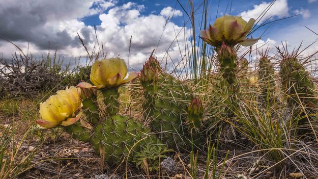
“Not having had any sleep. brought on a severe head ache—went after Cattle, hitch up and start at 8 A.M. down the River banks about 3 miles where we Watered the Cattle—left the River, ascended a steep Pebbly hill to a level Table Land, then about S.W. round a steep Bluff on the left of the road. descend the hill, to another valley came to a steep bank of a dry Creek. go up it ¼ of a Mile, down opposite side. Prest. Young orders a new & better road made across it. saves going round it. which was done—dust flying in two contrary directions—shortly after a slight portion of a heavy thunder shower passed over us—a level S.S. road to the River, and halt on the banks of “Black’s Fork” at 4.45 tolerable grass, best Camping spot since start. 20 miles. some Shrubby trees on the banks. Tallow Weed plenty—Warm morning. Cloudy in afternoon—rain in distance in several places. a gravel. and a sandy-dusty road all day. chiefly W. Wind. see Prickly Pear in Flower—some yellow, others Red. Several of the brethren continue sick.” – Thomas Bullock. Thomas’ journal can be viewed at https://history.churchofjesuschrist.org/overlandtravel/sources/4398/thomas-bullock-journals-1843-1849-journal-1847-april-june. The photograph from Pinedale, WY was downloaded at http://www.pinedaleonline.com/news/2018/06/Cactusinbloom.htm.
July 6
This day in Trail history – A composite journey along the California Trail – July 6, 1849
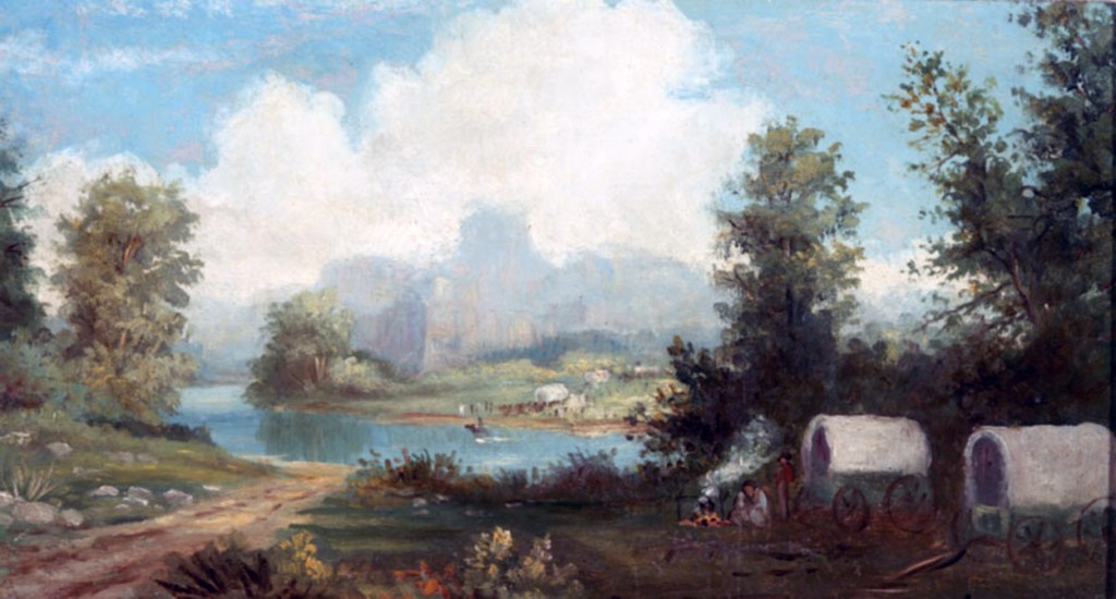
“Rose at 2 in the morning for the purpose of trying to cross over [Green River] before the government troops moved up from their encampment to give us trouble, as they did on the occasion of our crossing the Platte. But this time they were more polite and did not interfere with us. The moon shone brightly and gave us much aid in our operations. We assisted others and they, in turn assisted us—for, be it remembered, that we had to do all the work and pay four dollars beside for the use of the ferry to pass over every wagon. We were all over by 8 o’clock. The mules swam like so many rats. We left the river at ten o’clock, and went over some rough road, 17 miles, to a creek, where was a mound. The creek was very rapid and we were obliged to cross it at two different points. After passing over some hills, we encamped, at sun-down, near a branch. The wild sage here was the largest I had ever seen, measuring, in height, from six to eight feet, and in diameter six to nine inches, near the root. The hills around look barren and dreary beyond description. Distance 18 miles.” – Benjamin Biddle. Biddle’s diary can be viewed at https://donduncan.org/trails/biddle.htm. The painting “Green River” by George Ottinger was downloaded at https://history.churchofjesuschrist.org/media/pioneer-story-green-river-pioneers?lang=eng#1.
July 7
This day in Trail history – A composite journey along the California Trail – July 7, 1849
“cool Morning High winds colouds of dust passed lots of Snow Lying under the Banks of creeks campt 2½ miles from Sweet water and 10 miles from the South Pass we are now about as high as we will get on the Rocky Mountains fine Small Streams narrow valleys fine water and grass sage wood to cook with snow vary Plentiful” – M. A. Violette. Violette’s diary can be downloaded from the OCTA website at https://www.octa-journals.org/merrill-mattes-collection/diary-of-m-a-violette-1849. The painting of South Pass by William Henry Jackson was downloaded at https://contentdm.lib.byu.edu/digital/collection/Jackson/id/3424/.

