I wrote a series of social media posts regarding waterways along the California Trail and thought I’d share them here as well.
Rivers were the highways across the west. As roads were being developed for the western pioneers it made sense to follow the waterways because of availability of water and grass, and as a natural feature to use as a guide. During the month of April we’ll highlight each of the main waterways used to guide the emigrants along the California Trail.
After crossing the Missouri River near Independence, St. Joseph, or Council Bluffs, emigrants would make their way north until they met the Platte River, which would guide them across the Nebraska Territory. Most travellers remained on the south side of the river until reaching the point where the two forks (North and South Platte) joined, prompting a crossing of the river to follow the North Fork into Wyoming territory. As the years progressed, a north side road was opened as well. The North Platte would lead emigrants to Fort Laramie and then on to where Casper, Wyoming (and the National Historic Trails Interpretive Center) is located today.
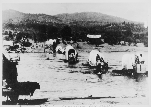
In her memoir of the 1849 trek, Luzena Stanley Wilson recalled, ” The Platte was the first great water-course we crossed. It is a peculiar, wide, shallow stream, with a quicksand bed. With the wagon-bed on blocks twelve or fourteen inches thick to raise it out of the water, some of the men astride of the oxen, some of them wading waist-deep, and all goading the poor beasts to keep them moving, we started across, The water poured into the wagon in spite of our precautions and floated off some of our few movables; but we landed safely on the other side, and turned to see the team behind us stop in mid-stream. The frantic driver shouted, whipped, belabored the stubborn animals in vain, and the treacherous sand gave way under their feet. They sank slowly, gradually, but surely. They went out of sight inch by inch, and the water rose over the moaning beasts. Without a struggle they disappeared beneath the surface. In a little while the broad South Platte swept on its way, sunny, sparkling, placid, without a ripple to mark where a lonely man parted with all his fortune.” Her memoir is available from the Library of Congress website. The photograph can be found at the University of Nebraska Lincoln Center for Digital Research.
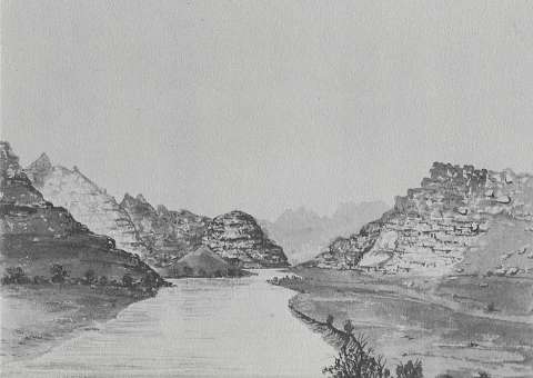
Once the emigrants left the North Platte River, they struck across a watershed divide in what is now central Wyoming to reach the Sweetwater River. The Sweetwater flows from the Continental Divide near South Pass to the North Platte River (in present-day Pathfinder Reservoir). You can read about crossings of the Sweetwater River on the Wyoming State Historical Society webpage here, here and here. A vivid story from July 3, 1849 was recorded in the Sweetwater Valley by A.J. McCall: “The road to-day was smooth, but quite hilly, so that we only made about fifteen miles, and encamped on the Sweetwater again. The cattle were turned out on a beautiful green meadow in a bend of the river, where there was very fine grazing. Just before the sun went down as I was watching the ruminating herd, I saw a great commotion among them and heard a mournful looing. I hurried … to ascertain the cause. I found … [the] ox, “Charlie,” lying … in the agonies of death [surrounded by] his associates, that for a thousand miles had toiled by his side, over mountain, desert and plain, [and] had gathered around him, manifesting deep sympathy, and when they saw him breathe his last breath, gave utterance to a sad wail. These poor ‘dumb and driven cattle’ were not alone in mourning the loss of this good, faithful creature. His death was undoubtedly caused by an injury received at the Platt Ferry. No more fitting resting place for his old bones could have been found than that sweet meadow on the bank of this murmuring stream in the heart of the ‘Old Rockies.’ McCall’s diary can be viewed at https://babel.hathitrust.org/cgi/pt?id=uc1.31158005904320&view=1up&seq=10. The sketch of the Sweetwater River is by James Wilkins, called “The Narrows”. It is from his book and diary from 1849, An Artist on the Overland Trail.
After crossing South Pass, pioneers made their way across the rest of present-day Wyoming, crossing three main rivers flowing generally north to south: Little Sandy Creek, Big Sandy Creek, and Green River. From Green River they made their way across a number of mountain/valley systems to reach Bear River in present-day Idaho. Bear River makes a big looping arch from Utah through Idaho and back into Utah to the Great Salt Lake, making it the longest river in North America which does not reach an ocean. Emigrants would either follow Bear River’s east leg north to Soda Springs (from Wyoming), or they would follow its west leg north from the Great Salt Lake to meet the California Trail near City ofocks, Idaho. Either way, Bear River was a guide through the winding valleys of Utah and Idaho.
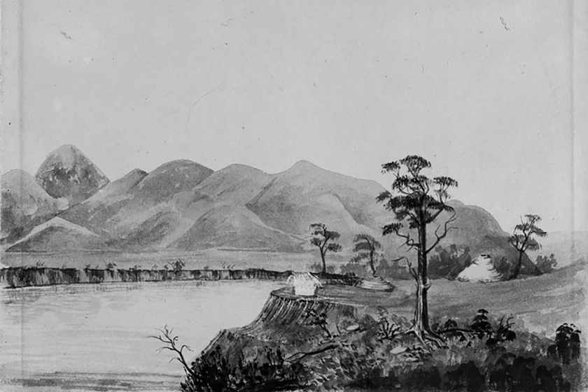
Explorer John C. Fremont commented on Oregon Trail Emigrants in July 1843 in Bear River Valley: “[the valley] presented a picture of home beauty that went directly to our hearts. The edge of the wood, for several miles along the river, was dotted with the white covers of emigrant wagons, collected in groups at different camps, where the smokes were rising lazily from the fires, around which the women were occupied in preparing the evening meal, and the children playing in the grass; and herds of cattle, grazing about in the bottom, had an air of quiet security and civilized comfort that made a rare sight for the traveller in such a remote wilderness.” You can read and download Fremont’s book on Google Books. The sketch of Steamboat Springs on Bear River is by James F. Wilkins in 1849 from his book An Artist on the Overland Trail.
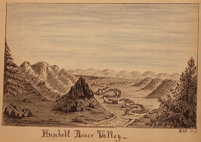
The National Park Services National Historic Trail Auto Tour Guide Across Nevada describes the Humboldt River as “sullen and spiteful, a mocking mean joker that lured emigrants deep into the desert, swindled them of all they possessed, and left them abandoned at last on a dead lake floor of silt and salt. Along its twisting course across today’s Nevada, the foul Humboldt River drove many California-bound travelers to despair and at least two to bitter poetry. ‘Meanest and muddiest, filthiest Stream, most cordially I hate you’ — Dr. Horace Belknap, 1850. ‘Farewell to thee! Thou Stinking turbid stream Amid whose waters frogs and Serpents gleam Thou putred mass of filth farewell forever For here again I’ll tempt my fortunes never’ —Adison Crain, 1852. The Humboldt was, as Western historian Dale Morgan wrote, ‘the most necessary river of America, and the most hated.’ Hated for its deep, reedy sloughs, which trapped and drowned thirst-crazed livestock. Hated for the stinking broth of mud and decay that dawdled down its meandering channels. Hated for the buzzing, biting insects and raucous coyotes that mobbed its banks. Hated for its willow thickets that concealed expert archers with poison-tipped arrows. Yet necessary, because the Humboldt River ambled in a curving diagonal from northeastern Nevada toward the gold fields of northern California. Necessary because it was a long, reliable (if repulsive) drink of water across some 300 miles of desert. Necessary because it enabled thousands of Americans to go west and help build a nation stretching from coast to coast. Necessary, too, for the survival and independence of the native peoples who lived, hunted, and harvested along its length. The Humboldt and its marshes, meadows, and lake were beautiful, not baleful, to the Shoshones and Paiutes. These waters provided them drink, a bounty of waterfowl, fish, and food plants to feed their families, and willows to make baskets and dwellings. For gold seekers and emigrating settlers, the Humboldt River was a necessary evil. For the native people of the Great Basin, it was lifegiver and home.” The drawing of the Humboldt River Valley is by Daniel Jenks, 1859, held in the collections of the Library of Congress.
River Canyons provided routes across the rugged Sierra Nevadas. The Bidwell/Bartleson party (first overland emigrant party) followed the Walker River drainage in 1841. The primary route through the Truckee Valley was established by the Stephens Party in 1844 and was used for many years. The Carson River route was established from west to east in 1848 by a Mormon Battalion heading to the Great Salt Lake from California. Once across the 40-mile desert in the rain shadow of the mountains, these river canyons were treacherous, but nevertheless provided passage into and through the mountains.
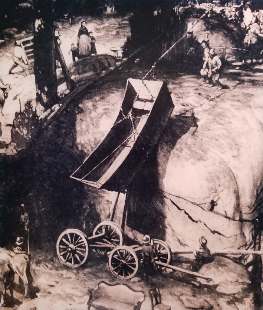
William Browder wrote, regarding the Walker River route, “leave the river up a steap hill and a short distans down a litel hill cros a mudey branch and up the hil on a graduel rise cros a nothur mudey branch to a canion some water at the mouth of the canion” (Sept. 15, 1853). On the Carson Route, Henry Sheldon Anable (Sept. 10, 1852) wrote, “After dinner we crossed the first mountain. The ascent is half a mile and much like going up the side of a house in steepness, with huge stones in the road, aside the road and all around the road.” William L. Todd described the Truckee Route in a letter regarding his 1845 journey: ” You can form no idea, nor can I give you any just description of the evils which beset us. From the time we left the lake on the north side of the mountains until we arrived at the Lake on the top, it was one continued jumping from one rocky cliff to another. We would have to roll over this big rock, then over that; then there was bridging a branch; then we had to lift our waggons by main force up to the top of a ledge of rocks, that it was impossible for us to reduce, bridge or roll our waggons over, and in several places, we had to run our waggons broadside off a ledge, take off our cattle, and throw our waggons round with handspikes, and heave them up to the top, where our cattle had been previously taken. Three days were passed in this vexatious way and at the end of that time, we found ourselves six miles from the lake on the north side of the mountain, and you never saw a set of fellows more happy than when we reached the summit.” The painting is by Harold Von Schmidt and is displayed on a panel in the California Trail Interpretive Center.